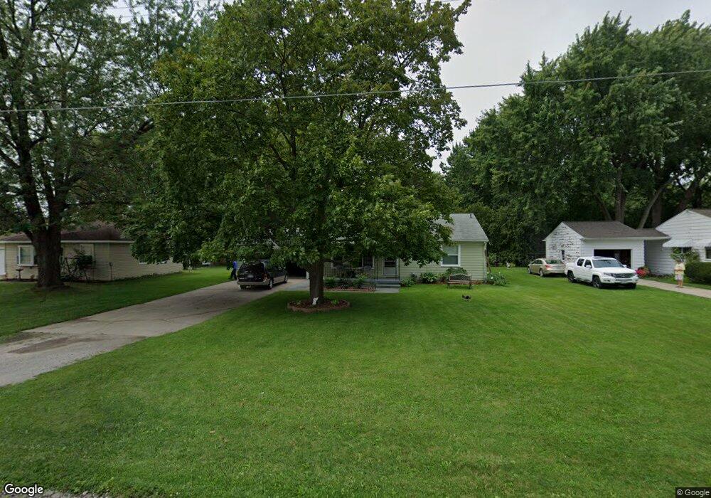
2091 Anderson Rd Saginaw, MI 48603
Estimated Value: $156,918 - $190,000
3
Beds
2
Baths
1,080
Sq Ft
$160/Sq Ft
Est. Value
About This Home
This home is located at 2091 Anderson Rd, Saginaw, MI 48603 and is currently estimated at $173,230, approximately $160 per square foot. 2091 Anderson Rd is a home located in Saginaw County with nearby schools including Weiss Elementary School, Sherwood Elementary School, and White Pine Middle School.
Ownership History
Date
Name
Owned For
Owner Type
Purchase Details
Closed on
Jan 30, 2002
Sold by
Whittier J I
Bought by
Whittier M
Current Estimated Value
Home Financials for this Owner
Home Financials are based on the most recent Mortgage that was taken out on this home.
Original Mortgage
$65,500
Outstanding Balance
$26,720
Interest Rate
6.87%
Mortgage Type
Purchase Money Mortgage
Estimated Equity
$146,510
Purchase Details
Closed on
Sep 11, 2001
Sold by
Whittier G I and J I
Bought by
Whittier I
Purchase Details
Closed on
Aug 11, 1999
Sold by
Gulvas Richard L and Gulvas Bradley J
Bought by
Whittier Gilbert and Whittier Josephine I
Home Financials for this Owner
Home Financials are based on the most recent Mortgage that was taken out on this home.
Original Mortgage
$51,000
Interest Rate
7.7%
Mortgage Type
Purchase Money Mortgage
Create a Home Valuation Report for This Property
The Home Valuation Report is an in-depth analysis detailing your home's value as well as a comparison with similar homes in the area
Home Values in the Area
Average Home Value in this Area
Purchase History
| Date | Buyer | Sale Price | Title Company |
|---|---|---|---|
| Whittier M | -- | -- | |
| Whittier Michael | -- | -- | |
| Whittier I | -- | -- | |
| Whittier Gilbert | $71,000 | -- |
Source: Public Records
Mortgage History
| Date | Status | Borrower | Loan Amount |
|---|---|---|---|
| Open | Whittier Michael | $65,500 | |
| Previous Owner | Whittier Gilbert | $51,000 |
Source: Public Records
Tax History Compared to Growth
Tax History
| Year | Tax Paid | Tax Assessment Tax Assessment Total Assessment is a certain percentage of the fair market value that is determined by local assessors to be the total taxable value of land and additions on the property. | Land | Improvement |
|---|---|---|---|---|
| 2025 | $1,876 | $63,500 | $0 | $0 |
| 2024 | $926 | $59,500 | $0 | $0 |
| 2023 | $861 | $52,900 | $0 | $0 |
| 2022 | $1,596 | $46,400 | $0 | $0 |
| 2021 | $1,473 | $40,900 | $0 | $0 |
| 2020 | $1,436 | $37,900 | $0 | $0 |
| 2019 | $1,373 | $37,600 | $6,200 | $31,400 |
| 2018 | $638 | $35,900 | $0 | $0 |
| 2017 | $1,225 | $36,200 | $0 | $0 |
| 2016 | $1,210 | $35,300 | $0 | $0 |
| 2014 | $1,183 | $37,100 | $0 | $28,900 |
| 2013 | -- | $36,300 | $0 | $0 |
Source: Public Records
Map
Nearby Homes
- 2090 -2092 Anderson
- 1908 W Packard Dr
- 4810 Nimitz St
- 2105 Marlou Ct
- 1807 Hemmeter Rd
- 1735 Hemmeter Rd
- 2201 Augsburg Dr
- 1640 W Delta Dr
- 2611 Bradford Dr
- 2400 Linda St
- 1478 Cammin Dr
- 4168 Vera St
- 5287 Weiss St
- 1558 Sauk Ln
- 5475 George St
- 2588 E Greendale Dr
- 19 Cobblestone Place Unit 19
- 1751 Lathrup Ave
- 1340 Trout Dr
- 1449 Sauk Ln
- 2081 Anderson Rd
- 2111 Anderson Rd
- 2090 Bock Rd
- 2080 Bock Rd
- 2100 Anderson Rd
- 2110 Bock Rd
- 2090 Anderson Rd
- 2129 Anderson Rd
- 2116 Anderson Rd
- 2066 Bock Rd
- 2124 Bock Rd
- 2126 Anderson Rd
- 2092 Anderson Rd
- 2040 Bock Rd
- 2134 Anderson Rd
- 2130 Bock Rd
- 2147 Anderson Rd
- 2085 Bock Rd
- 2140 Anderson Rd
- 2111 Bock Rd