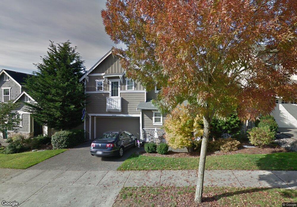
20926 12th Ave W Lynnwood, WA 98036
Queensborough-Brentwood NeighborhoodEstimated Value: $988,721 - $1,137,000
4
Beds
3
Baths
1,970
Sq Ft
$538/Sq Ft
Est. Value
About This Home
This home is located at 20926 12th Ave W, Lynnwood, WA 98036 and is currently estimated at $1,059,930, approximately $538 per square foot. 20926 12th Ave W is a home located in Snohomish County with nearby schools including Brier Elementary School, Brier Terrace Middle School, and Mountlake Terrace High School.
Ownership History
Date
Name
Owned For
Owner Type
Purchase Details
Closed on
May 6, 2005
Sold by
Camwest Development Inc
Bought by
Gripentrog Jeffrey Alan and Gripentrog Julie K
Current Estimated Value
Home Financials for this Owner
Home Financials are based on the most recent Mortgage that was taken out on this home.
Original Mortgage
$336,750
Outstanding Balance
$177,610
Interest Rate
6.02%
Mortgage Type
Fannie Mae Freddie Mac
Estimated Equity
$882,320
Create a Home Valuation Report for This Property
The Home Valuation Report is an in-depth analysis detailing your home's value as well as a comparison with similar homes in the area
Home Values in the Area
Average Home Value in this Area
Purchase History
| Date | Buyer | Sale Price | Title Company |
|---|---|---|---|
| Gripentrog Jeffrey Alan | $420,950 | Chicago Title |
Source: Public Records
Mortgage History
| Date | Status | Borrower | Loan Amount |
|---|---|---|---|
| Open | Gripentrog Jeffrey Alan | $336,750 |
Source: Public Records
Tax History Compared to Growth
Tax History
| Year | Tax Paid | Tax Assessment Tax Assessment Total Assessment is a certain percentage of the fair market value that is determined by local assessors to be the total taxable value of land and additions on the property. | Land | Improvement |
|---|---|---|---|---|
| 2025 | $6,333 | $810,100 | $505,000 | $305,100 |
| 2024 | $6,333 | $763,000 | $465,000 | $298,000 |
| 2023 | $7,384 | $934,200 | $595,000 | $339,200 |
| 2022 | $6,245 | $641,100 | $353,000 | $288,100 |
| 2020 | $6,451 | $612,200 | $311,000 | $301,200 |
| 2019 | $5,798 | $583,600 | $307,000 | $276,600 |
| 2018 | $5,878 | $467,900 | $220,000 | $247,900 |
| 2017 | $4,861 | $399,900 | $168,000 | $231,900 |
| 2016 | $4,352 | $358,700 | $148,000 | $210,700 |
| 2015 | $4,338 | $339,900 | $135,000 | $204,900 |
| 2013 | $3,844 | $285,700 | $113,000 | $172,700 |
Source: Public Records
Map
Nearby Homes
- 20914 13th Place W
- 20823 14th Place W
- 1423 212th Place SW
- 20822 Damson Rd
- 0 Larch Way Unit NWM2427085
- 1132 Crawford Rd
- 923 207th St SW
- 212 xx Cypress Way
- 604 213th St SW
- 528 213th St SW
- 20932 3rd Ave W
- 20027 10th Ave W
- 607 217th St SW
- 20431 20th Place W
- 20815 23rd Ave W
- 1815 201st Place SW
- 21648 21st Ave W
- 19812 13th Place W
- 19727 Locust Way
- 20029 S Danvers Rd
- 20922 12th Ave W
- 20930 12th Ave W
- 20929 13th Ave W
- 20918 12th Ave W
- 20925 13th Ave W
- 20931 13th Ave W
- 20917 13th Ave W
- 20925 12th Ave W
- 20914 12th Ave W
- 20921 12th Ave W
- 21001 12th Ave W
- 20917 12th Ave W
- 21005 12th Ave W
- 1216 210th Place SW
- 1210 210th Place SW
- 20913 12th Ave W
- 1222 210th Place SW
- 20910 12th Ave W
- 20905 13th Ave W
- 21011 12th Ave W