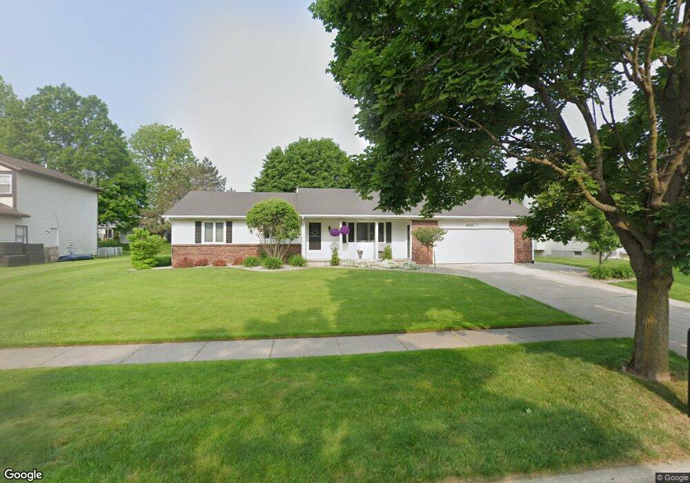
2093 Pheasant Ave NW Grand Rapids, MI 49534
Estimated Value: $352,639 - $386,000
3
Beds
3
Baths
1,288
Sq Ft
$291/Sq Ft
Est. Value
About This Home
This home is located at 2093 Pheasant Ave NW, Grand Rapids, MI 49534 and is currently estimated at $374,410, approximately $290 per square foot. 2093 Pheasant Ave NW is a home located in Kent County with nearby schools including Kenowa Hills Central Elementary School, Kenowa Hills Middle School, and Kenowa Hills High School.
Ownership History
Date
Name
Owned For
Owner Type
Purchase Details
Closed on
Jan 28, 1999
Sold by
Ortiz Robert
Bought by
Kersjes John A and Kersjes John A
Current Estimated Value
Purchase Details
Closed on
Sep 15, 1998
Sold by
Fleming Thomas J
Bought by
Ortiz Robert and Kersjes John A
Purchase Details
Closed on
Oct 18, 1994
Sold by
Coon Judy M
Bought by
Fleming Thomas J and Kersjes John A
Purchase Details
Closed on
Jun 14, 1991
Bought by
Coon Judy M and Kersjes John A
Create a Home Valuation Report for This Property
The Home Valuation Report is an in-depth analysis detailing your home's value as well as a comparison with similar homes in the area
Home Values in the Area
Average Home Value in this Area
Purchase History
| Date | Buyer | Sale Price | Title Company |
|---|---|---|---|
| Kersjes John A | $136,500 | -- | |
| Ortiz Robert | $129,400 | -- | |
| Fleming Thomas J | $128,600 | -- | |
| Coon Judy M | $101,900 | -- |
Source: Public Records
Tax History Compared to Growth
Tax History
| Year | Tax Paid | Tax Assessment Tax Assessment Total Assessment is a certain percentage of the fair market value that is determined by local assessors to be the total taxable value of land and additions on the property. | Land | Improvement |
|---|---|---|---|---|
| 2025 | $2,337 | $167,100 | $0 | $0 |
| 2024 | $2,337 | $152,400 | $0 | $0 |
| 2023 | $2,235 | $132,400 | $0 | $0 |
| 2022 | $2,404 | $118,100 | $0 | $0 |
| 2021 | $2,343 | $110,900 | $0 | $0 |
| 2020 | $2,056 | $107,500 | $0 | $0 |
| 2019 | $3,866 | $96,700 | $0 | $0 |
| 2018 | $2,223 | $92,200 | $0 | $0 |
| 2017 | $2,161 | $87,400 | $0 | $0 |
| 2016 | $2,077 | $81,700 | $0 | $0 |
| 2015 | $1,961 | $81,700 | $0 | $0 |
| 2013 | -- | $73,200 | $0 | $0 |
Source: Public Records
Map
Nearby Homes
- 3120 Richmond St NW
- 2260 Elmridge Dr NW
- 3560 Richmond St NW
- 2505 Longmeadow St NW
- 2716 Elmridge Dr NW
- 1474 Marlin Ave NW
- 2432 Eastwinde Ct NW
- 3405 3 Mile Rd NW
- 1969 Oak Hollow Rd NW
- 3262 Rypens Dr NW
- 1789 Oakleigh Woods Dr NW
- 1300 Lancaster Ave NW
- 1660 Oakleigh Rd NW
- 2268 Pin Oak Ct NW Unit 91
- 1814 Corville Ct NW
- 2040 Blue Bellway NW Unit 46
- 2549 Meadow Ridge Dr Unit 51
- 1340 Northrup Ave NW
- 3511 3 Mile Rd NW
- 1537 Browning Dr
- 2105 Pheasant Ave NW
- 2079 Pheasant Ave NW
- 2092 Lamont Ave NW
- 2119 Pheasant Ave NW
- 2067 Pheasant Ave NW
- 2108 Lamont Ave NW
- 2074 Lamont Ave NW
- 2092 Pheasant Ave NW
- 2104 Pheasant Ave NW
- 2078 Pheasant Ave NW
- 2126 Lamont Ave NW
- 2133 Pheasant Ave NW
- 2055 Pheasant Ave NW
- 2118 Pheasant Ave NW
- 2060 Lamont Ave NW
- 2064 Pheasant Ave NW
- 2132 Pheasant Ave NW
- 2142 Lamont Ave NW
- 2147 Pheasant Ave NW
- 2055 Meadowdale Dr NW