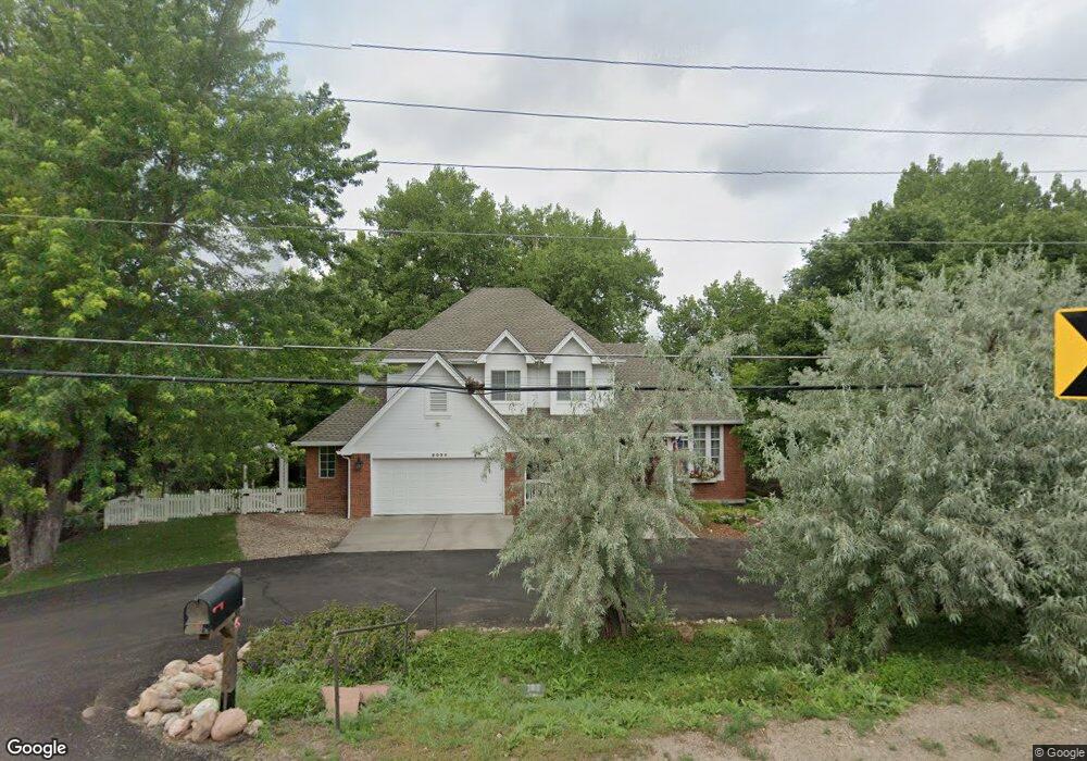
2095 Simms St Lakewood, CO 80215
Applewood Valley NeighborhoodEstimated Value: $994,627 - $1,196,000
4
Beds
6
Baths
2,426
Sq Ft
$446/Sq Ft
Est. Value
About This Home
This home is located at 2095 Simms St, Lakewood, CO 80215 and is currently estimated at $1,081,657, approximately $445 per square foot. 2095 Simms St is a home located in Jefferson County with nearby schools including Stober Elementary School, Everitt Middle School, and Wheat Ridge High School.
Ownership History
Date
Name
Owned For
Owner Type
Purchase Details
Closed on
Apr 19, 2022
Sold by
Manica Keith J
Bought by
Keith J Manica And Lynne G Aronson Living Tru
Current Estimated Value
Purchase Details
Closed on
Aug 27, 1996
Sold by
Blue Diamond Properties
Bought by
Manica Keith J and Aronson Lynne G
Home Financials for this Owner
Home Financials are based on the most recent Mortgage that was taken out on this home.
Original Mortgage
$233,300
Interest Rate
8.27%
Create a Home Valuation Report for This Property
The Home Valuation Report is an in-depth analysis detailing your home's value as well as a comparison with similar homes in the area
Home Values in the Area
Average Home Value in this Area
Purchase History
| Date | Buyer | Sale Price | Title Company |
|---|---|---|---|
| Keith J Manica And Lynne G Aronson Living Tru | -- | None Listed On Document | |
| Manica Keith J | $291,632 | Land Title |
Source: Public Records
Mortgage History
| Date | Status | Borrower | Loan Amount |
|---|---|---|---|
| Previous Owner | Manica Keith J | $233,300 |
Source: Public Records
Tax History Compared to Growth
Tax History
| Year | Tax Paid | Tax Assessment Tax Assessment Total Assessment is a certain percentage of the fair market value that is determined by local assessors to be the total taxable value of land and additions on the property. | Land | Improvement |
|---|---|---|---|---|
| 2024 | $4,544 | $54,096 | $16,914 | $37,182 |
| 2023 | $4,544 | $54,096 | $16,914 | $37,182 |
| 2022 | $4,097 | $48,514 | $11,165 | $37,349 |
| 2021 | $4,131 | $49,910 | $11,486 | $38,424 |
| 2020 | $4,367 | $45,202 | $8,916 | $36,286 |
| 2019 | $4,311 | $45,202 | $8,916 | $36,286 |
| 2018 | $4,187 | $42,783 | $9,019 | $33,764 |
| 2017 | $3,767 | $42,783 | $9,019 | $33,764 |
| 2016 | $3,479 | $37,173 | $8,248 | $28,925 |
| 2015 | $3,489 | $39,316 | $8,248 | $31,068 |
| 2014 | $3,489 | $33,964 | $7,911 | $26,053 |
Source: Public Records
Map
Nearby Homes
- 2140 Tabor Dr
- 2110 Tabor Dr
- 2055 Quail Dr
- 1825 Simms St
- 1832 Simms St Unit 1832A
- 11715 W 18th Ave
- 1830 Simms St
- 11423 W 17th Place Unit I11423
- 11217 W 18th Ave Unit A
- 1802 Simms St
- 11422 W 17th Place
- 1723 Robb St Unit 45
- 1723 Robb St Unit 26
- 11340 Benthaven Dr
- 11813 W 17th Ave
- 2368 Ward Dr
- 1678 Tabor St
- 12075 W 18th Dr
- 11734 W Applewood Knolls Dr
- 11569 W 27th Ave
- 2134 Tabor Place
- 2075 Simms St
- 2166 Tabor Place
- 2170 Tabor Dr
- 11701 W 21st Place
- 2164 Tabor Place
- 2075 Routt St
- 2150 Tabor Place
- 2035 Routt St
- 2105 Routt St
- 11711 W 21st Place
- 2180 Simms Place
- 2055 Simms St
- 2050 Simms St
- 2175 Tabor Dr
- 2120 Tabor Dr
- 11702 W 21st Place
- 2165 Tabor Dr
- 2115 Routt St
- 2023 Routt St