2095 West St Wrentham, MA 02093
West Wrentham NeighborhoodEstimated payment $16,150/month
Highlights
- 65.5 Acre Lot
- Wetlands on Lot
- No HOA
- Delaney Elementary School Rated A
- Wooded Lot
- Jogging Path
About This Lot
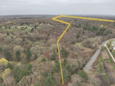
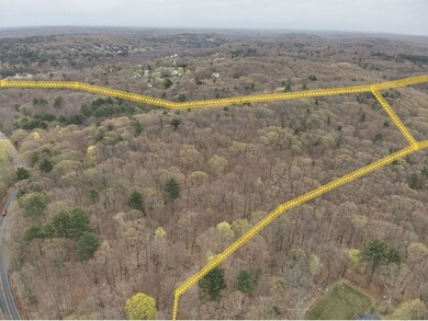
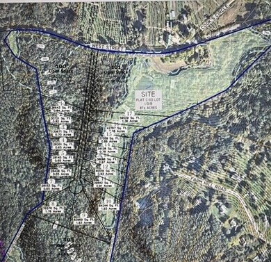
Calling all developers...this is a rare opportunity to acquire such a large parcel of raw land in Wrentham. Consisting of over 65 acres of land with approximately 2500 feet of frontage on West Street, there are a number of possible uses as it is located within an R87 residential and agricultural zoning area. Sellers have a completed wetland survey in hand. This beautiful, forested area is close to Franklin State Forest, Wrentham Outlets, Cook's Farm and the Rhode Island border. Buyer is responsible for their own due diligence on the property. Appointments for accompanied showings are required.
Property Details
Property Type
- Land
Est. Annual Taxes
- $4,247
Lot Details
- 65.5 Acre Lot
- Sloped Lot
- Wooded Lot
- Property is zoned R-87
Location
- Property is near schools
Schools
- King Phillip Middle School
- King Phillip High School
Listing and Financial Details
- Assessor Parcel Number M:C03 B:01 L:03B,3503314
Community Details
Overview
- No Home Owners Association
- Near Conservation Area
Amenities
- Shops
Recreation
- Park
- Jogging Path
- Electricity Available at Street
- Wetlands on Lot
Map
Home Values in the Area
Average Home Value in this Area
Tax History
| Year | Tax Paid | Tax Assessment Tax Assessment Total Assessment is a certain percentage of the fair market value that is determined by local assessors to be the total taxable value of land and additions on the property. | Land | Improvement |
|---|---|---|---|---|
| 2025 | $4,469 | $255,080 | $235,680 | $19,400 |
| 2024 | $4,431 | $255,080 | $235,680 | $19,400 |
| 2023 | $4,247 | $252,180 | $220,180 | $32,000 |
| 2022 | $4,506 | $247,880 | $215,880 | $32,000 |
| 2021 | $4,146 | $237,980 | $205,980 | $32,000 |
| 2020 | $3,762 | $204,580 | $172,580 | $32,000 |
| 2019 | $3,387 | $185,680 | $161,780 | $23,900 |
| 2018 | $0 | $181,890 | $162,790 | $19,100 |
| 2017 | $0 | $178,610 | $0 | $0 |
| 2016 | -- | $173,310 | $0 | $0 |
| 2015 | $2,634 | $175,810 | $0 | $0 |
| 2014 | $2,602 | $169,960 | $0 | $0 |
Property History
| Date | Event | Price | List to Sale | Price per Sq Ft |
|---|---|---|---|---|
| 12/28/2024 12/28/24 | Pending | -- | -- | -- |
| 01/31/2024 01/31/24 | Price Changed | $3,000,000 | -20.0% | -- |
| 01/22/2024 01/22/24 | For Sale | $3,750,000 | -- | -- |
Purchase History
| Date | Type | Sale Price | Title Company |
|---|---|---|---|
| Deed | $225,000 | -- | |
| Deed | $225,000 | -- |
Mortgage History
| Date | Status | Loan Amount | Loan Type |
|---|---|---|---|
| Previous Owner | $517,300 | Purchase Money Mortgage |
Source: MLS Property Information Network (MLS PIN)
MLS Number: 73195484
APN: WREN-000003C-000001-000003-B000000
- 50 Wamsutta Way
- 236 Williams St
- 25 Nature View Dr
- 60 Grant Ave
- 20 Nature View Dr
- 2 Duhamel Way
- 9 Pebble Cir Unit 9
- 65 Palmetto Dr Unit 65
- 851 Washington St
- 21 Palmetto Dr Unit 21
- 24 Palmetto Dr Unit 24
- 180 Pine Swamp Rd
- 56 Pine Swamp Rd
- 50 Heather Ln
- 17 Stanford Rd
- 219 Dawn Blvd
- 29 Squire Ln
- 1250 Pulaski Blvd
- 10 Stanford Rd
- 124 Lake St


