Estimated Value: $310,000 - $407,039
Studio
--
Bath
1,480
Sq Ft
$246/Sq Ft
Est. Value
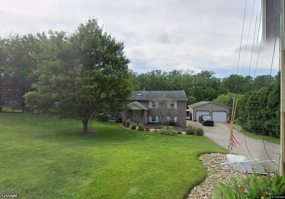
About This Home
This home is located at 2099 Robbins Station Rd, Irwin, PA 15642 and is currently estimated at $363,760, approximately $245 per square foot. 2099 Robbins Station Rd is a home located in Westmoreland County with nearby schools including Sunset Valley El School, Hillcrest Intermediate School, and Norwin Middle School.
Ownership History
Date
Name
Owned For
Owner Type
Purchase Details
Closed on
Jan 29, 2007
Sold by
Crossett Ronald G and Crossett Nancy J
Bought by
Fiorillo Robert J and Fiorillo Jacqueline L
Current Estimated Value
Home Financials for this Owner
Home Financials are based on the most recent Mortgage that was taken out on this home.
Original Mortgage
$213,750
Outstanding Balance
$124,669
Interest Rate
6.24%
Mortgage Type
Unknown
Estimated Equity
$239,091
Create a Home Valuation Report for This Property
The Home Valuation Report is an in-depth analysis detailing your home's value as well as a comparison with similar homes in the area
Home Values in the Area
Average Home Value in this Area
Purchase History
| Date | Buyer | Sale Price | Title Company |
|---|---|---|---|
| Fiorillo Robert J | $225,000 | None Available |
Source: Public Records
Mortgage History
| Date | Status | Borrower | Loan Amount |
|---|---|---|---|
| Open | Fiorillo Robert J | $213,750 |
Source: Public Records
Tax History
| Year | Tax Paid | Tax Assessment Tax Assessment Total Assessment is a certain percentage of the fair market value that is determined by local assessors to be the total taxable value of land and additions on the property. | Land | Improvement |
|---|---|---|---|---|
| 2026 | $3,446 | $25,280 | $4,670 | $20,610 |
| 2025 | $3,231 | $25,280 | $4,670 | $20,610 |
| 2024 | $3,088 | $24,540 | $4,670 | $19,870 |
| 2023 | $2,916 | $24,540 | $4,670 | $19,870 |
| 2022 | $2,892 | $24,540 | $4,670 | $19,870 |
| 2021 | $2,892 | $24,540 | $4,670 | $19,870 |
| 2020 | $2,833 | $24,540 | $4,670 | $19,870 |
| 2019 | $2,762 | $24,540 | $4,670 | $19,870 |
| 2018 | $2,703 | $24,540 | $4,670 | $19,870 |
| 2017 | $2,644 | $24,540 | $4,670 | $19,870 |
| 2016 | $2,540 | $24,540 | $4,670 | $19,870 |
| 2015 | $2,540 | $24,540 | $4,670 | $19,870 |
| 2014 | $2,494 | $24,540 | $4,670 | $19,870 |
Source: Public Records
Map
Nearby Homes
- 2139 Northwest Dr
- 1681 Robbins Station Rd
- 1521 Robbins Station Rd
- 12620 Glennwood Dr
- 11621 Beacon Dr
- 11639 Dartmoor Dr
- LOT 3 Lynch Dr
- LOT 2 Lynch Dr
- LOT 5 Lynch Dr
- 0 Ridge Rd
- 9030 Lucia Ln
- 12219 Roth Dr
- Parcel 3R Frank Wood Ridge Rd
- 12509 Herold Dr
- 00 Stanyard Ln
- 11490 Mckee Rd
- 2505 Lot 2 Guffey Rd
- 11384 James St
- 1974 Tara Dr
- 11911 North St
- 2119 Robbins Station Rd
- 2079 Robbins Station Rd
- 2050 Robbins Station Rd
- 1941 Robbins Station Rd
- 2010 Robbins Station Rd
- 2100 Robbins Station Rd
- 2120 Robbins Station Rd
- 1970 Robbins Station Rd
- 2150 Robbins Station Rd
- 2191 Robbins Station Rd
- 1224 Lone Star Ln
- 1910 Robbins Station Rd
- 1911 Robbins Station Rd
- 2110 Robbins Station Rd
- 2221 Robbins Station Rd
- 1200 Autumn Ln
- 2255 Northwest Dr
- 2499 Spicher Hill Rd
- 2215 Northwest Dr
- 1172 Autumn Ln
Your Personal Tour Guide
Ask me questions while you tour the home.