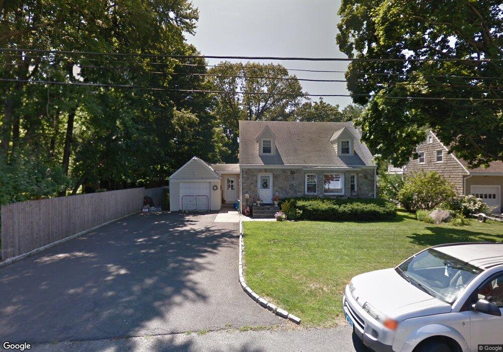
21 Barbara Dr Norwalk, CT 06851
Downtown Norwalk NeighborhoodEstimated Value: $673,000 - $796,359
3
Beds
3
Baths
1,820
Sq Ft
$395/Sq Ft
Est. Value
About This Home
This home is located at 21 Barbara Dr, Norwalk, CT 06851 and is currently estimated at $718,590, approximately $394 per square foot. 21 Barbara Dr is a home located in Fairfield County with nearby schools including Naramake Elementary School, Nathan Hale Middle School, and Norwalk High School.
Ownership History
Date
Name
Owned For
Owner Type
Purchase Details
Closed on
Nov 5, 2021
Sold by
Dbi Development Llc
Bought by
Dacunto Luigi G
Current Estimated Value
Home Financials for this Owner
Home Financials are based on the most recent Mortgage that was taken out on this home.
Original Mortgage
$548,000
Outstanding Balance
$501,375
Interest Rate
2.88%
Mortgage Type
Purchase Money Mortgage
Estimated Equity
$217,215
Purchase Details
Closed on
Nov 15, 1994
Sold by
Lametto Richard and Lametto Patricia
Bought by
Flewellyn Scott and Calka Gerri
Home Financials for this Owner
Home Financials are based on the most recent Mortgage that was taken out on this home.
Original Mortgage
$163,000
Interest Rate
8.78%
Mortgage Type
Unknown
Create a Home Valuation Report for This Property
The Home Valuation Report is an in-depth analysis detailing your home's value as well as a comparison with similar homes in the area
Home Values in the Area
Average Home Value in this Area
Purchase History
| Date | Buyer | Sale Price | Title Company |
|---|---|---|---|
| Dacunto Luigi G | $685,000 | None Available | |
| Flewellyn Scott | $185,000 | -- | |
| Flewellyn Scott | $185,000 | -- |
Source: Public Records
Mortgage History
| Date | Status | Borrower | Loan Amount |
|---|---|---|---|
| Open | Dacunto Luigi G | $548,000 | |
| Previous Owner | Flewellyn Scott | $300,000 | |
| Previous Owner | Flewellyn Scott | $153,500 | |
| Previous Owner | Flewellyn Scott | $6,000 | |
| Previous Owner | Flewellyn Scott | $163,000 |
Source: Public Records
Tax History Compared to Growth
Tax History
| Year | Tax Paid | Tax Assessment Tax Assessment Total Assessment is a certain percentage of the fair market value that is determined by local assessors to be the total taxable value of land and additions on the property. | Land | Improvement |
|---|---|---|---|---|
| 2025 | $10,842 | $452,780 | $172,650 | $280,130 |
| 2024 | $10,682 | $452,780 | $172,650 | $280,130 |
| 2023 | $8,532 | $339,100 | $131,880 | $207,220 |
| 2022 | $8,373 | $339,100 | $131,880 | $207,220 |
| 2021 | $8,155 | $339,100 | $131,880 | $207,220 |
| 2020 | $8,151 | $339,100 | $131,880 | $207,220 |
| 2019 | $7,923 | $339,100 | $131,880 | $207,220 |
| 2018 | $7,081 | $265,590 | $143,770 | $121,820 |
| 2017 | $6,838 | $265,590 | $143,770 | $121,820 |
| 2016 | $6,773 | $265,590 | $143,770 | $121,820 |
| 2015 | $6,754 | $265,590 | $143,770 | $121,820 |
| 2014 | $6,666 | $265,590 | $143,770 | $121,820 |
Source: Public Records
Map
Nearby Homes
- 2 Clearview Ave
- 49 Barbara Dr
- 16 Katy Ln
- 44 Ambler Dr
- 77 Walter Ave
- 162 Strawberry Hill Ave
- 15 Dry Hill Rd
- 14 Dairy Farm Rd
- 42 County St
- 12 Merrill Rd
- 25 Dairy Farm Rd
- 9 Park St Unit 217
- 360 Westport Ave Unit 1
- 24 Sawmill Rd
- 6 Plumley Cir
- 71 Saddle Rd
- 18 Roxbury Rd
- 44 King St
- 31 High St Unit 4-2B
- 65 Wolfpit Ave Unit 5C