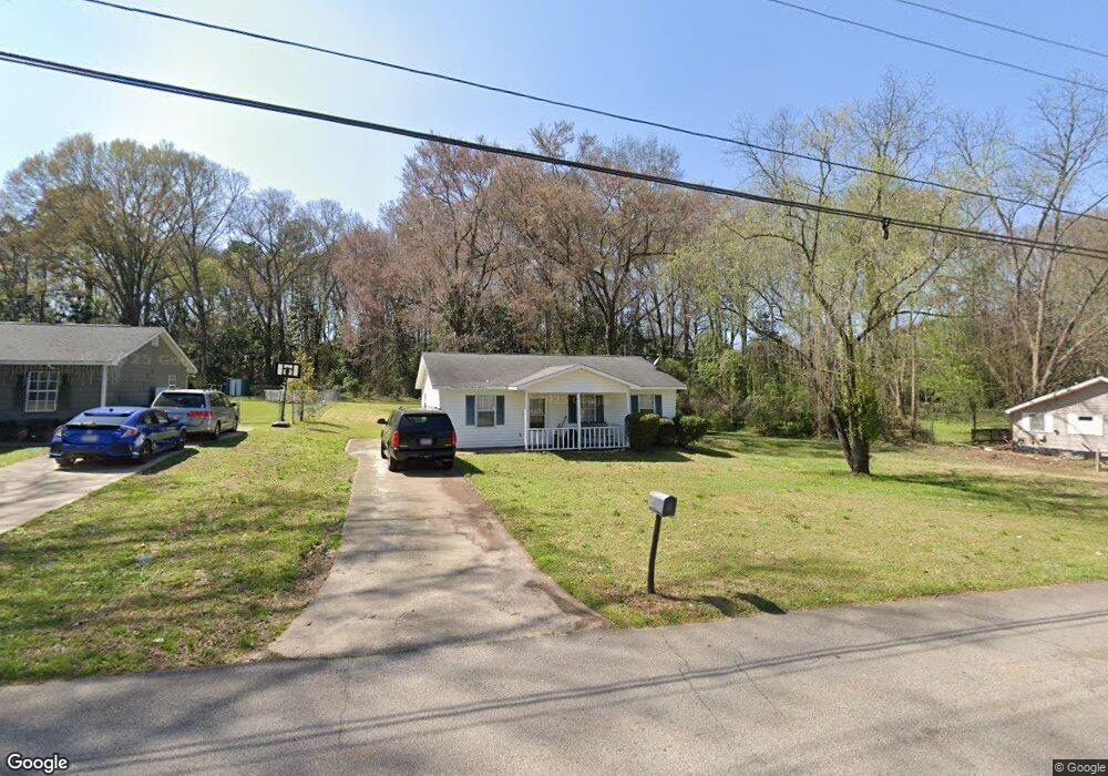
21 Barnard Ave Lagrange, GA 30241
Estimated Value: $154,903 - $197,000
3
Beds
2
Baths
952
Sq Ft
$180/Sq Ft
Est. Value
About This Home
This home is located at 21 Barnard Ave, Lagrange, GA 30241 and is currently estimated at $171,726, approximately $180 per square foot. 21 Barnard Ave is a home located in Troup County with nearby schools including Franklin Forest Elementary School, Hollis Hand Elementary School, and Ethel W. Kight Elementary School.
Ownership History
Date
Name
Owned For
Owner Type
Purchase Details
Closed on
Jun 13, 2025
Sold by
Rocky Acres Real Estate Llc
Bought by
Davis Allison and Davis Lucas
Current Estimated Value
Home Financials for this Owner
Home Financials are based on the most recent Mortgage that was taken out on this home.
Original Mortgage
$171,731
Outstanding Balance
$170,691
Interest Rate
6.81%
Mortgage Type
FHA
Estimated Equity
$1,035
Purchase Details
Closed on
Jan 30, 2021
Sold by
Upchurch Joel
Bought by
Rocky Acres Real Estate Llc
Purchase Details
Closed on
Sep 24, 2010
Sold by
Wachovia Mtg Corp
Bought by
Upchurch Joel
Purchase Details
Closed on
Jul 18, 2007
Sold by
T S Investment Properties
Bought by
Oates Christopher
Home Financials for this Owner
Home Financials are based on the most recent Mortgage that was taken out on this home.
Original Mortgage
$84,500
Interest Rate
6.65%
Mortgage Type
New Conventional
Purchase Details
Closed on
May 31, 2002
Sold by
Billy D Stewart
Bought by
T&S Investment Properties Inc
Purchase Details
Closed on
Mar 13, 2002
Sold by
James R Arrington
Bought by
Billy D Stewart
Purchase Details
Closed on
Mar 12, 2002
Sold by
James Arrington
Bought by
James R Arrington
Purchase Details
Closed on
Jun 21, 1996
Bought by
James Arrington
Create a Home Valuation Report for This Property
The Home Valuation Report is an in-depth analysis detailing your home's value as well as a comparison with similar homes in the area
Purchase History
| Date | Buyer | Sale Price | Title Company |
|---|---|---|---|
| Davis Allison | $174,900 | -- | |
| Rocky Acres Real Estate Llc | -- | -- | |
| Upchurch Joel | $34,500 | -- | |
| Upchurch Joel | $34,500 | -- | |
| Oates Christopher | $84,500 | -- | |
| T&S Investment Properties Inc | -- | -- | |
| Billy D Stewart | $64,600 | -- | |
| James R Arrington | -- | -- | |
| James Arrington | -- | -- |
Source: Public Records
Mortgage History
| Date | Status | Borrower | Loan Amount |
|---|---|---|---|
| Open | Davis Allison | $171,731 | |
| Previous Owner | Oates Christopher | $84,500 |
Source: Public Records
Tax History
| Year | Tax Paid | Tax Assessment Tax Assessment Total Assessment is a certain percentage of the fair market value that is determined by local assessors to be the total taxable value of land and additions on the property. | Land | Improvement |
|---|---|---|---|---|
| 2025 | $825 | $30,240 | $4,600 | $25,640 |
| 2024 | $825 | $30,240 | $4,600 | $25,640 |
| 2023 | $701 | $30,240 | $4,600 | $25,640 |
| 2022 | $805 | $28,840 | $4,600 | $24,240 |
| 2021 | $758 | $25,120 | $3,840 | $21,280 |
| 2020 | $758 | $25,120 | $3,840 | $21,280 |
| 2019 | $572 | $18,960 | $3,400 | $15,560 |
| 2018 | $572 | $18,960 | $3,400 | $15,560 |
| 2017 | $572 | $18,960 | $3,400 | $15,560 |
| 2016 | $571 | $18,945 | $3,400 | $15,545 |
| 2015 | $586 | $19,400 | $3,854 | $15,545 |
| 2014 | $562 | $18,581 | $3,854 | $14,727 |
| 2013 | -- | $19,762 | $3,854 | $15,908 |
Source: Public Records
Map
Nearby Homes
- 5 Curran Ave
- 4 1/2 Barnard Ave
- 204 Cleveland Dr
- 212 Cleveland Dr
- 15 Fulton St
- 87 Youngs Mill Rd
- 115 Clara Jean Ct
- 2 Louise St
- 0 N Barnard Ave
- 3 Gulfstream Dr
- 5 Gulfstream Dr
- 110 Lenox Cir
- 107 N Barnard Ave
- 224 Rutland Cir
- 147 Shenandoah Ln
- 146 Shenandoah Ln
- 143 Shenandoah Ln
- 141 Shenandoah Ln
- 139 Shenandoah Ln
- 142 Shenandoah Ln
- 21 1/2 N Barnard Ave
- 19 Barnard Ave
- 23 Barnard Ave
- 20 Barnard Ave
- 22 Barnard Ave
- 17 Barnard Ave
- 18 Barnard Ave
- 24 Barnard Ave
- 15 Barnard Ave
- 16 Barnard Ave
- 26 Barnard Ave
- 19 Thornton St
- 28 Barnard Ave
- 17 Thornton St
- 27 Barnard Ave
- 21 Thornton St
- 15 Thornton St
- 14 Barnard Ave
- 11 Barnard Ave
- 23 Thornton St
Your Personal Tour Guide
Ask me questions while you tour the home.