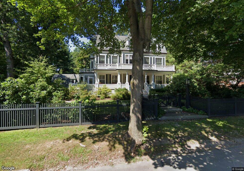
21 Berkeley St West Newton, MA 02465
West Newton NeighborhoodEstimated Value: $3,815,000 - $4,737,000
6
Beds
5
Baths
4,196
Sq Ft
$1,025/Sq Ft
Est. Value
About This Home
This home is located at 21 Berkeley St, West Newton, MA 02465 and is currently estimated at $4,302,030, approximately $1,025 per square foot. 21 Berkeley St is a home located in Middlesex County with nearby schools including Peirce Elementary School, F.A. Day Middle School, and Newton North High School.
Ownership History
Date
Name
Owned For
Owner Type
Purchase Details
Closed on
Dec 28, 2020
Sold by
Zients-Pucker Leslie
Bought by
Leslie Zients Pucker Irt
Current Estimated Value
Purchase Details
Closed on
Dec 22, 2020
Sold by
Leslie Zients Pucker Ret
Bought by
Pucker Kenneth P and Zients-Pucker Leslie
Purchase Details
Closed on
Dec 23, 2014
Sold by
Pucker Leslie Z and Pucker Kenneth P
Bought by
Leslie Zients Pucker R
Purchase Details
Closed on
Apr 13, 2004
Sold by
Tedaldi Robert D and Tedaldi Ruth E
Bought by
Pucker Kenneth P and Pucker Leslie Z
Purchase Details
Closed on
Aug 24, 1989
Sold by
Sullivan Vincent C
Bought by
Tedaldi Robert D
Create a Home Valuation Report for This Property
The Home Valuation Report is an in-depth analysis detailing your home's value as well as a comparison with similar homes in the area
Home Values in the Area
Average Home Value in this Area
Purchase History
We collect this data history from publicly available records. To have your information removed, we recommend requesting removal directly through your county’s website.
| Date | Buyer | Sale Price | Title Company |
|---|---|---|---|
| Leslie Zients Pucker Irt | -- | None Available | |
| Pucker Ft 2016 | -- | None Available | |
| Pucker Kenneth P | -- | None Available | |
| Leslie Zients Pucker R | -- | -- | |
| Pucker Kenneth P | $2,475,000 | -- | |
| Tedaldi Robert D | $770,000 | -- |
Source: Public Records
Mortgage History
We collect this data history from publicly available records. To have your information removed, we recommend requesting removal directly through your county’s website.
| Date | Status | Borrower | Loan Amount |
|---|---|---|---|
| Previous Owner | Tedaldi Robert D | $100,000 | |
| Previous Owner | Tedaldi Robert D | $200,000 |
Source: Public Records
Tax History
| Year | Tax Paid | Tax Assessment Tax Assessment Total Assessment is a certain percentage of the fair market value that is determined by local assessors to be the total taxable value of land and additions on the property. | Land | Improvement |
|---|---|---|---|---|
| 2025 | $45,620 | $4,655,100 | $1,431,800 | $3,223,300 |
| 2024 | $44,110 | $4,519,500 | $1,390,100 | $3,129,400 |
| 2023 | $42,882 | $4,212,400 | $1,098,900 | $3,113,500 |
| 2022 | $41,032 | $3,900,400 | $1,017,500 | $2,882,900 |
| 2021 | $39,592 | $3,679,600 | $959,900 | $2,719,700 |
| 2020 | $38,415 | $3,679,600 | $959,900 | $2,719,700 |
| 2019 | $37,332 | $3,572,400 | $931,900 | $2,640,500 |
| 2018 | $36,235 | $3,348,900 | $834,100 | $2,514,800 |
| 2017 | $35,131 | $3,159,300 | $786,900 | $2,372,400 |
| 2016 | $33,601 | $2,952,600 | $735,400 | $2,217,200 |
| 2015 | $32,008 | $2,756,900 | $687,300 | $2,069,600 |
Source: Public Records
Map
Nearby Homes
- 97 Valentine St
- 308 Prince St
- 49 Shaw St
- 210 Evelyn Rd
- 56 Bigelow Rd
- 148 Dartmouth St
- 443 Chestnut St
- 1640 Commonwealth Ave
- 91 Mary Ellen Rd
- 40 Greenwood Ave
- 189 Mount Vernon St
- 86 Webster St
- 19 Dunstan St Unit 19
- 29 Gammons Rd
- 51 Fairfield St
- 73 Auburn St Unit 75
- 462 Waltham St
- 444 Lowell Ave
- 444 Lowell Ave Unit 444
- 442 Lowell Ave Unit 444
Your Personal Tour Guide
Ask me questions while you tour the home.