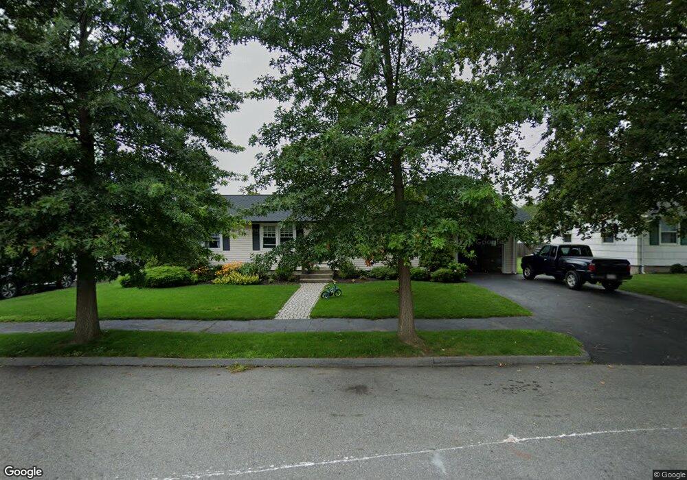
21 Birmingham Rd Worcester, MA 01606
Burncoat NeighborhoodEstimated Value: $411,461 - $456,000
3
Beds
1
Bath
1,144
Sq Ft
$378/Sq Ft
Est. Value
About This Home
This home is located at 21 Birmingham Rd, Worcester, MA 01606 and is currently estimated at $432,865, approximately $378 per square foot. 21 Birmingham Rd is a home located in Worcester County with nearby schools including Belmont Street Community School, Jacob Hiatt Magnet School, and Chandler Magnet.
Ownership History
Date
Name
Owned For
Owner Type
Purchase Details
Closed on
Oct 28, 2009
Sold by
Quinlivan Robert F
Bought by
Quinlivan Robert F and Quinlivan Margaret M
Current Estimated Value
Purchase Details
Closed on
Dec 28, 2007
Sold by
Quinlivan Ft and Quinlivan John E
Bought by
Quinlivan Robert F
Purchase Details
Closed on
May 3, 2000
Sold by
Cummings Gertrude F
Bought by
Quinlivan John E and Qunlivan Anne L
Create a Home Valuation Report for This Property
The Home Valuation Report is an in-depth analysis detailing your home's value as well as a comparison with similar homes in the area
Home Values in the Area
Average Home Value in this Area
Purchase History
| Date | Buyer | Sale Price | Title Company |
|---|---|---|---|
| Quinlivan Robert F | -- | -- | |
| Quinlivan Robert F | $156,666 | -- | |
| Quinlivan John E | $140,000 | -- |
Source: Public Records
Mortgage History
| Date | Status | Borrower | Loan Amount |
|---|---|---|---|
| Open | Quinlivan John E | $109,000 | |
| Previous Owner | Quinlivan John E | $50,000 |
Source: Public Records
Tax History Compared to Growth
Tax History
| Year | Tax Paid | Tax Assessment Tax Assessment Total Assessment is a certain percentage of the fair market value that is determined by local assessors to be the total taxable value of land and additions on the property. | Land | Improvement |
|---|---|---|---|---|
| 2025 | $4,926 | $373,500 | $117,700 | $255,800 |
| 2024 | $4,822 | $350,700 | $117,700 | $233,000 |
| 2023 | $4,663 | $325,200 | $102,400 | $222,800 |
| 2022 | $4,131 | $271,600 | $81,900 | $189,700 |
| 2021 | $3,993 | $245,300 | $65,500 | $179,800 |
| 2020 | $3,905 | $229,700 | $65,500 | $164,200 |
| 2019 | $3,668 | $203,800 | $58,900 | $144,900 |
| 2018 | $3,557 | $188,100 | $58,900 | $129,200 |
| 2017 | $3,577 | $186,100 | $58,900 | $127,200 |
| 2016 | $3,487 | $169,200 | $42,900 | $126,300 |
| 2015 | $3,396 | $169,200 | $42,900 | $126,300 |
| 2014 | $3,306 | $169,200 | $42,900 | $126,300 |
Source: Public Records
Map
Nearby Homes
- 49 Prudential Rd
- 80 Prudential Rd
- 12 Prudential Rd
- 68 Housatonic St
- 15 Inwood Rd
- 89 E Mountain St
- 95 Saint Nicholas Ave
- 43 Fales St
- 2 Maria Ln Unit 2
- 14 Housatonic St
- 29 E Mountain
- 13 Fatima Ln
- 31 Enaya Cir Unit 31
- 3 Malden St
- 14 Fales St
- 40 Francis St
- 80 Clark St
- 314 Burncoat St
- 602 Burncoat St
- 126 Brooks St
- 19 Birmingham Rd
- 23 Birmingham Rd
- 24 Michigan Rd
- 22 Michigan Rd
- 26 Michigan Rd
- 17 Birmingham Rd
- 20 Birmingham Rd
- 20 Birmingham Rd Unit 1
- 25 Birmingham Rd
- 20 Michigan Rd
- 18 Birmingham Rd
- 22 Birmingham Rd
- 31 Birmingham Rd
- 24 Birmingham Rd
- 16 Birmingham Rd
- 18 Michigan Rd
- 15 Birmingham Rd
- 25 Hartford Rd
- 21 Michigan Rd
- 27 Hartford Rd