
Seller's Agent in 2025
Tiffany Plevka
The Bella Group, LLC
(860) 201-7325
5 in this area
13 Total Sales
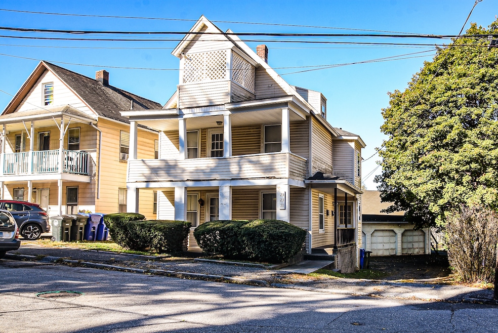
Seize the opportunity to revitalize this classic 1920's 3-unit multi-family home located in the heart of Torrington. This property screams great potential from top to bottom but in need of renovations. This home offers three separate units. First floor and Second floor have 2 bedrooms and 1 bathroom, and the Third floor has 1 bedroom and 1 bathroom. Separate entrances and utilities for easy tenant management. Full unfinished basement with laundry hook-up for 2nd Fl and storage for tenants. 1st Floor has laundry in unit. Off street parking and 3 car detached garage. Walkable neighborhood, near schools, parks, shopping and downtown Torrington. Offering a blank canvas for the savvy investor or owner-occupant. This home is being sold AS IS.
Last Agent to Sell the Property
The Bella Group, LLC Brokerage Phone: (860) 201-7325 License #RES.0818294 Listed on: 11/07/2025
| Date | Type | Sale Price | Title Company |
|---|---|---|---|
| Warranty Deed | $270,000 | -- | |
| Warranty Deed | $122,000 | -- |
| Date | Status | Loan Amount | Loan Type |
|---|---|---|---|
| Open | $202,500 | New Conventional | |
| Previous Owner | $120,378 | FHA |
| Date | Event | Price | List to Sale | Price per Sq Ft |
|---|---|---|---|---|
| 12/23/2025 12/23/25 | Sold | $273,000 | +5.4% | $140 / Sq Ft |
| 11/11/2025 11/11/25 | Pending | -- | -- | -- |
| 11/07/2025 11/07/25 | For Sale | $259,000 | -- | $133 / Sq Ft |
| Year | Tax Paid | Tax Assessment Tax Assessment Total Assessment is a certain percentage of the fair market value that is determined by local assessors to be the total taxable value of land and additions on the property. | Land | Improvement |
|---|---|---|---|---|
| 2025 | $7,216 | $187,670 | $20,160 | $167,510 |
| 2024 | $4,455 | $92,880 | $20,160 | $72,720 |
| 2023 | $4,455 | $92,880 | $20,160 | $72,720 |
| 2022 | $4,378 | $92,880 | $20,160 | $72,720 |
| 2021 | $4,288 | $92,880 | $20,160 | $72,720 |
| 2020 | $4,288 | $92,880 | $20,160 | $72,720 |
| 2019 | $3,480 | $75,380 | $20,160 | $55,220 |
| 2018 | $3,480 | $75,380 | $20,160 | $55,220 |
| 2017 | $3,436 | $75,110 | $20,160 | $54,950 |
| 2016 | $3,436 | $75,110 | $20,160 | $54,950 |
| 2015 | $3,436 | $75,110 | $20,160 | $54,950 |
| 2014 | $3,515 | $96,780 | $26,040 | $70,740 |
Seller's Agent in 2025
Tiffany Plevka
The Bella Group, LLC
(860) 201-7325
5 in this area
13 Total Sales
J
Buyer's Agent in 2025
Jonathan Arpi
eXp Realty
(609) 508-2054
1 in this area
14 Total Sales
Source: SmartMLS
MLS Number: 24137776
APN: TORR-000118-000020-000004
Disclaimer: Certain information contained herein is derived from information provided by parties other than Homes.com. All information provided is deemed reliable, but is not guaranteed to be accurate and should be independently verified.
![]() IDX information is provided exclusively for personal, non-commercial use, and may not be used for any purpose other than to identify prospective properties consumers may be interested in purchasing. Information is deemed reliable but not guaranteed.
IDX information is provided exclusively for personal, non-commercial use, and may not be used for any purpose other than to identify prospective properties consumers may be interested in purchasing. Information is deemed reliable but not guaranteed.
Ask me questions while you tour the home.