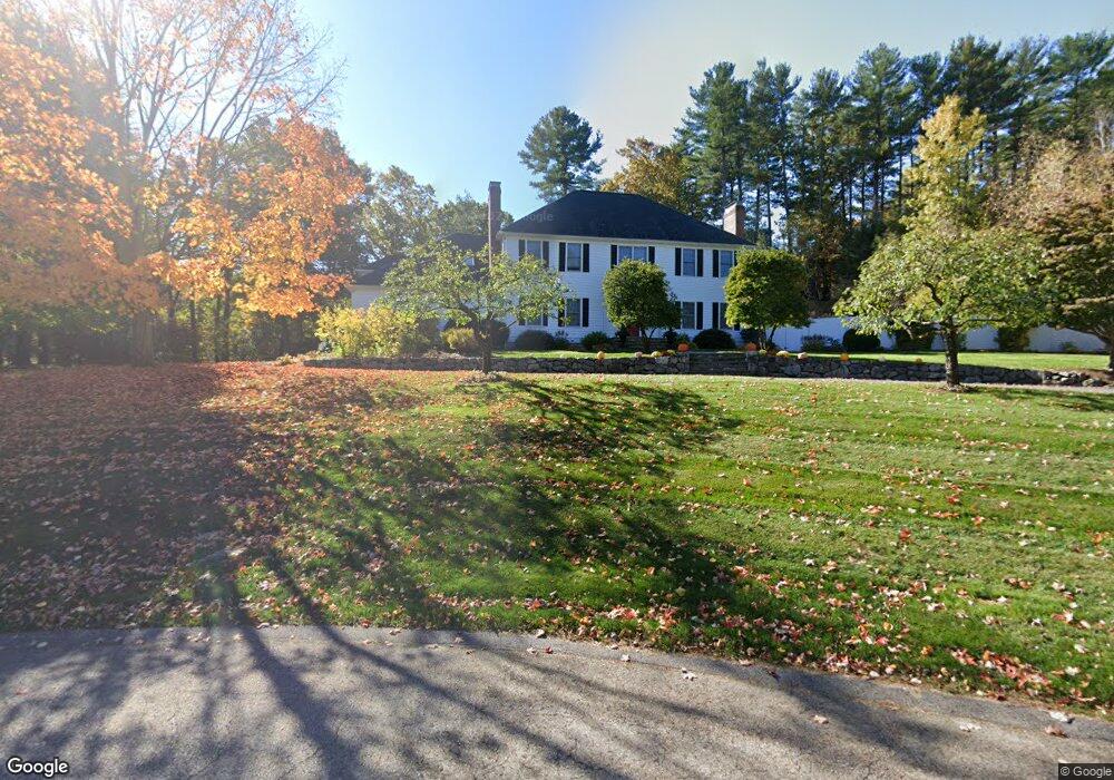
21 Carroll Cir Weston, MA 02493
Estimated Value: $2,683,036 - $3,128,000
5
Beds
5
Baths
4,198
Sq Ft
$696/Sq Ft
Est. Value
About This Home
This home is located at 21 Carroll Cir, Weston, MA 02493 and is currently estimated at $2,923,509, approximately $696 per square foot. 21 Carroll Cir is a home located in Middlesex County with nearby schools including Country Elementary School, Woodland Elementary School, and Weston Middle School.
Ownership History
Date
Name
Owned For
Owner Type
Purchase Details
Closed on
Dec 30, 2021
Sold by
Panagakos Rt
Bought by
Margolis Diane
Current Estimated Value
Home Financials for this Owner
Home Financials are based on the most recent Mortgage that was taken out on this home.
Original Mortgage
$750,000
Outstanding Balance
$685,517
Interest Rate
2.5%
Mortgage Type
Purchase Money Mortgage
Estimated Equity
$2,237,992
Purchase Details
Closed on
Feb 21, 2018
Sold by
Panagakos Michael J and Panagakos Julie D
Bought by
Panagakos Rt
Purchase Details
Closed on
Dec 30, 1996
Sold by
Murphy James P and Murphy Vicki L
Bought by
Panagakos Michael J and Panagakos Julie D
Purchase Details
Closed on
Dec 15, 1993
Sold by
Lot 7 Carroll Cir Rt and Kane Roger K
Bought by
Murphy James P and Murphy Vicki L
Create a Home Valuation Report for This Property
The Home Valuation Report is an in-depth analysis detailing your home's value as well as a comparison with similar homes in the area
Home Values in the Area
Average Home Value in this Area
Purchase History
| Date | Buyer | Sale Price | Title Company |
|---|---|---|---|
| Margolis Diane | $2,395,000 | None Available | |
| Panagakos Rt | -- | -- | |
| Panagakos Michael J | $620,000 | -- | |
| Murphy James P | $615,000 | -- |
Source: Public Records
Mortgage History
| Date | Status | Borrower | Loan Amount |
|---|---|---|---|
| Open | Margolis Diane | $750,000 | |
| Previous Owner | Murphy James P | $539,322 | |
| Previous Owner | Murphy James P | $218,000 |
Source: Public Records
Tax History Compared to Growth
Tax History
| Year | Tax Paid | Tax Assessment Tax Assessment Total Assessment is a certain percentage of the fair market value that is determined by local assessors to be the total taxable value of land and additions on the property. | Land | Improvement |
|---|---|---|---|---|
| 2025 | $26,125 | $2,353,600 | $911,100 | $1,442,500 |
| 2024 | $25,688 | $2,310,100 | $911,100 | $1,399,000 |
| 2023 | $25,772 | $2,176,700 | $911,100 | $1,265,600 |
| 2022 | $22,273 | $1,738,700 | $859,500 | $879,200 |
| 2021 | $21,487 | $1,655,400 | $815,000 | $840,400 |
| 2020 | $21,112 | $1,645,500 | $815,000 | $830,500 |
| 2019 | $19,433 | $1,543,500 | $760,100 | $783,400 |
| 2018 | $19,448 | $1,554,600 | $761,500 | $793,100 |
| 2017 | $19,400 | $1,564,500 | $761,500 | $803,000 |
| 2016 | $19,135 | $1,573,600 | $761,500 | $812,100 |
| 2015 | $18,728 | $1,525,100 | $725,100 | $800,000 |
Source: Public Records
Map
Nearby Homes
- 120 Church St
- 51 Church St
- 17 Lexington St
- 60 Rolling Ln
- 15 Whitney Tavern Rd
- 167 Conant Rd
- 6 Overlook Dr
- 4 Willow Rd
- 202 Bear Hill Rd
- 3 October Ln
- 226 Ash St
- 8 Jericho Rd Unit 8
- 24 Jericho Rd Unit 24
- 154 Newton St
- 11 Winthrop Cir
- 52 Jericho Rd Unit 52
- 60 Possum Rd
- 1 Aberdeen Rd
- 9 Atlas Ln
- 51 Willard Rd