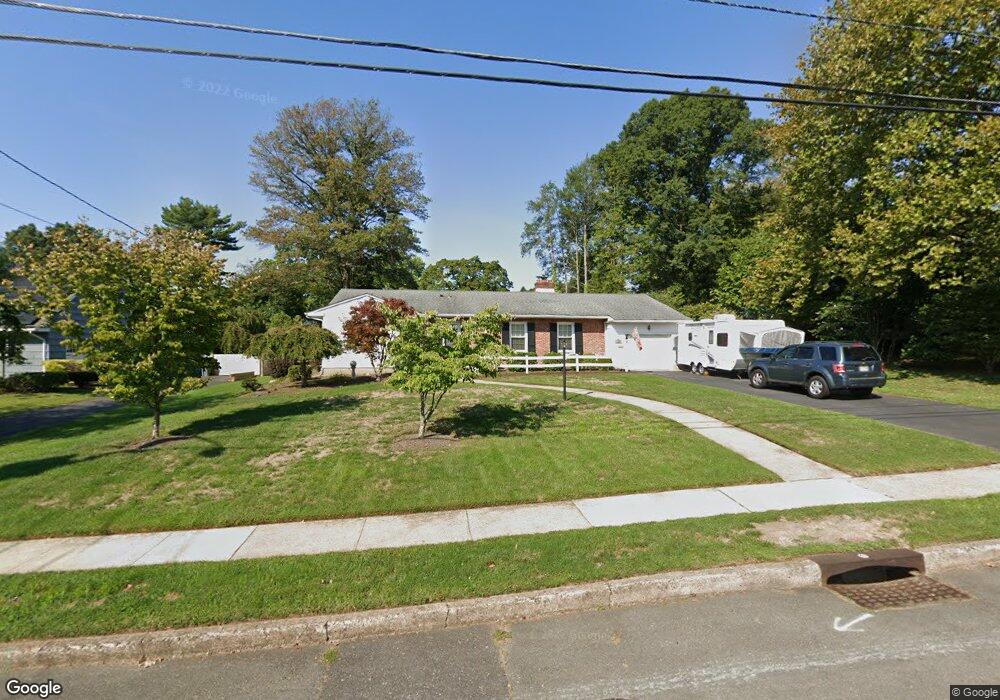
21 Farm Rd Ewing, NJ 08638
Ewingville NeighborhoodEstimated Value: $457,773 - $638,000
--
Bed
--
Bath
2,333
Sq Ft
$230/Sq Ft
Est. Value
About This Home
This home is located at 21 Farm Rd, Ewing, NJ 08638 and is currently estimated at $537,693, approximately $230 per square foot. 21 Farm Rd is a home located in Mercer County with nearby schools including Ewing High School, Trenton Stem-To-Civics Charter School, and Guidepost Montessori at Lawrenceville.
Ownership History
Date
Name
Owned For
Owner Type
Purchase Details
Closed on
Aug 15, 2001
Sold by
Walley Mary
Bought by
Benedetti Anthony and Benedetti Denise
Current Estimated Value
Home Financials for this Owner
Home Financials are based on the most recent Mortgage that was taken out on this home.
Original Mortgage
$160,000
Outstanding Balance
$61,962
Interest Rate
7.05%
Estimated Equity
$475,731
Purchase Details
Closed on
Nov 16, 1990
Sold by
Pratt Thomas E and Pratt Jeanne M
Bought by
Hannon Mary H
Create a Home Valuation Report for This Property
The Home Valuation Report is an in-depth analysis detailing your home's value as well as a comparison with similar homes in the area
Home Values in the Area
Average Home Value in this Area
Purchase History
| Date | Buyer | Sale Price | Title Company |
|---|---|---|---|
| Benedetti Anthony | $200,000 | -- | |
| Hannon Mary H | $171,800 | -- |
Source: Public Records
Mortgage History
| Date | Status | Borrower | Loan Amount |
|---|---|---|---|
| Open | Benedetti Anthony | $160,000 |
Source: Public Records
Tax History Compared to Growth
Tax History
| Year | Tax Paid | Tax Assessment Tax Assessment Total Assessment is a certain percentage of the fair market value that is determined by local assessors to be the total taxable value of land and additions on the property. | Land | Improvement |
|---|---|---|---|---|
| 2025 | $10,474 | $266,300 | $82,000 | $184,300 |
| 2024 | $9,845 | $266,300 | $82,000 | $184,300 |
| 2023 | $9,845 | $266,300 | $82,000 | $184,300 |
| 2022 | $9,579 | $266,300 | $82,000 | $184,300 |
| 2021 | $9,344 | $266,300 | $82,000 | $184,300 |
| 2020 | $9,211 | $266,300 | $82,000 | $184,300 |
| 2019 | $8,972 | $266,300 | $82,000 | $184,300 |
| 2018 | $8,219 | $155,600 | $55,000 | $100,600 |
| 2017 | $8,410 | $155,600 | $55,000 | $100,600 |
| 2016 | $8,297 | $155,600 | $55,000 | $100,600 |
| 2015 | $8,186 | $155,600 | $55,000 | $100,600 |
| 2014 | $8,164 | $155,600 | $55,000 | $100,600 |
Source: Public Records
Map
Nearby Homes
- 2148 Pennington Rd
- 24 Federal City Rd
- 4 Old Forge Ln
- 25 Fran Ave
- 15 Brophy Dr
- 23 Sabrina Dr
- 13 Lopatcong Dr
- 89 Upper Ferry Rd
- 6 Holiday Ct
- 56 Holiday Ct
- 5 Corey Dr
- 4 Hickory Hill Dr
- 222 Masterson Ct
- 146 Masterson Ct
- 325 Masterson Ct
- 313 Masterson Ct Unit 313
- 71 Carlton Ave
- 435 Masterson Ct
- 214 Point Ct
- 38 Running Brook Rd