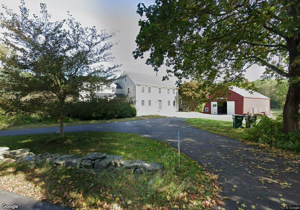
21 Finn Rd Harvard, MA 01451
Estimated Value: $1,152,000 - $1,291,000
4
Beds
3
Baths
3,565
Sq Ft
$345/Sq Ft
Est. Value
About This Home
This home is located at 21 Finn Rd, Harvard, MA 01451 and is currently estimated at $1,230,690, approximately $345 per square foot. 21 Finn Rd is a home located in Worcester County.
Ownership History
Date
Name
Owned For
Owner Type
Purchase Details
Closed on
Nov 20, 2024
Sold by
Monath Thomas P and Garvan Margaret B
Bought by
Margaret Blake Garvan T and Margaret Garvan
Current Estimated Value
Purchase Details
Closed on
Jun 30, 1992
Sold by
Spash John L and Spash Mary L
Bought by
Monath Thomas P and Garvan Margaret B
Home Financials for this Owner
Home Financials are based on the most recent Mortgage that was taken out on this home.
Original Mortgage
$483,600
Interest Rate
8.57%
Mortgage Type
Purchase Money Mortgage
Create a Home Valuation Report for This Property
The Home Valuation Report is an in-depth analysis detailing your home's value as well as a comparison with similar homes in the area
Home Values in the Area
Average Home Value in this Area
Purchase History
| Date | Buyer | Sale Price | Title Company |
|---|---|---|---|
| Margaret Blake Garvan T | -- | None Available | |
| Margaret Blake Garvan T | -- | None Available | |
| Monath Thomas P | $420,000 | -- |
Source: Public Records
Mortgage History
| Date | Status | Borrower | Loan Amount |
|---|---|---|---|
| Previous Owner | Monath Thomas P | $500,000 | |
| Previous Owner | Monath Thomas P | $452,000 | |
| Previous Owner | Monath Thomas P | $483,600 |
Source: Public Records
Tax History Compared to Growth
Tax History
| Year | Tax Paid | Tax Assessment Tax Assessment Total Assessment is a certain percentage of the fair market value that is determined by local assessors to be the total taxable value of land and additions on the property. | Land | Improvement |
|---|---|---|---|---|
| 2025 | $16,387 | $1,047,100 | $374,200 | $672,900 |
| 2024 | $15,736 | $1,056,100 | $374,200 | $681,900 |
| 2023 | $15,816 | $952,200 | $354,300 | $597,900 |
| 2022 | $15,216 | $849,600 | $375,100 | $474,500 |
| 2021 | $9,738 | $795,500 | $375,100 | $420,400 |
| 2020 | $9,751 | $761,600 | $375,100 | $386,500 |
| 2019 | $13,236 | $759,800 | $375,100 | $384,700 |
| 2018 | $321 | $791,300 | $375,100 | $416,200 |
| 2017 | $320 | $718,000 | $335,100 | $382,900 |
| 2016 | $8,581 | $718,600 | $335,100 | $383,500 |
Source: Public Records
Map
Nearby Homes
- 13 Pine Hill Way
- 14 Pine Hill Way
- 16 A Pine Hill Way Unit 16AA
- 18 B Pine Hill Way Unit BB
- 310 Codman Hill Rd Unit 35D
- 90 Corn Rd
- 19 Partridge Hill Rd
- 184 Old Bolton Rd
- 76 Bolton Woods Way
- 1155 Burroughs Rd
- 19 Barton Rd
- 21 Woodside Rd
- 176 Swanson Rd Unit 309
- 9 Cortland Dr Unit 9
- 53 Swanson Ct Unit 36C
- 98 Meadow Rd
- 220 Swanson Rd Unit 605
- 220 Swanson Rd Unit 606
- 220 Swanson Rd Unit 604
- 42 Swanson Ct Unit 14A