
Seller's Agent in 2025
Carrie Shea
Camelot Real Estate
(203) 858-7699
14 in this area
15 Total Sales
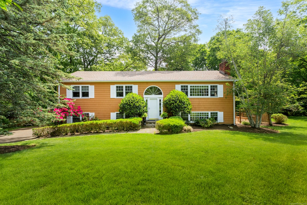
Travel down a private country lane to the end of the cul-de-sac and you have found your home! Located in a popular neighborhood just minutes to town center and Weston's award winning school campus is this pristine, meticulously maintained 4 BR / 3 Full bath home offering a host of amenities and special features. Relax with your morning coffee in the updated kitchen with a wall of glass overlooking 2 beautiful acres of property and the 62 acre Katharine Ordway Nature Preserve. The kitchen opens to the large dining room and bright sunroom/family room. A light and bright spacious living room has a wide picture window and brick fireplace. The primary bedroom has ensuite bath, walk-in closet and sliders leading to a private balcony overlooking the beautiful grounds. 2 other large bedrooms on the main floor share a recently updated bath. The fourth bedroom and full bath are located in the fully above grade, walk out lower level along with two huge flexible living spaces.... think media room, playroom, office, studio etc. Off the back of the house is the large deck offering lots of outdoor space for barbeques and relaxing on summer days while everyone plays in the yard or ride bikes in the cul-de-sac! Great lower Weston location just 2.3 miles to town and school campus, 3.9 miles to Merritt Parkway and just 5 miles to downtown Westport. Don't miss this opportunity to make this gem of a home your own!
Last Agent to Sell the Property
Camelot Real Estate License #RES.0751851 Listed on: 06/10/2025
| Date | Type | Sale Price | Title Company |
|---|---|---|---|
| Warranty Deed | $919,000 | -- | |
| Warranty Deed | $720,000 | -- | |
| Warranty Deed | $720,000 | -- | |
| Warranty Deed | $405,000 | -- |
| Date | Status | Loan Amount | Loan Type |
|---|---|---|---|
| Open | $735,200 | Future Advance Clause Open End Mortgage | |
| Previous Owner | $345,000 | Stand Alone Refi Refinance Of Original Loan | |
| Previous Owner | $314,837 | No Value Available | |
| Previous Owner | $345,000 | Purchase Money Mortgage |
| Date | Event | Price | List to Sale | Price per Sq Ft |
|---|---|---|---|---|
| 09/15/2025 09/15/25 | Sold | $919,000 | 0.0% | $362 / Sq Ft |
| 06/30/2025 06/30/25 | Pending | -- | -- | -- |
| 06/12/2025 06/12/25 | For Sale | $919,000 | -- | $362 / Sq Ft |
| Year | Tax Paid | Tax Assessment Tax Assessment Total Assessment is a certain percentage of the fair market value that is determined by local assessors to be the total taxable value of land and additions on the property. | Land | Improvement |
|---|---|---|---|---|
| 2025 | $11,992 | $501,760 | $191,520 | $310,240 |
| 2024 | $11,776 | $501,760 | $191,520 | $310,240 |
| 2023 | $11,610 | $351,170 | $191,520 | $159,650 |
| 2022 | $11,578 | $351,170 | $191,520 | $159,650 |
| 2021 | $11,561 | $351,170 | $191,520 | $159,650 |
| 2020 | $11,367 | $351,170 | $191,520 | $159,650 |
| 2019 | $5,460 | $351,170 | $191,520 | $159,650 |
| 2018 | $5,403 | $356,700 | $212,500 | $144,200 |
| 2017 | $10,312 | $356,700 | $212,500 | $144,200 |
| 2016 | $10,187 | $356,700 | $212,500 | $144,200 |
| 2015 | $10,259 | $356,700 | $212,500 | $144,200 |
| 2014 | $10,073 | $356,700 | $212,500 | $144,200 |
Seller's Agent in 2025
Carrie Shea
Camelot Real Estate
(203) 858-7699
14 in this area
15 Total Sales
Buyer's Agent in 2025
Diane DelVecchio
Corcoran Centric Realty
(917) 921-4043
1 in this area
34 Total Sales
Source: SmartMLS
MLS Number: 24100420
APN: WSTN-000024-000004-000019
Disclaimer: Certain information contained herein is derived from information provided by parties other than Homes.com. All information provided is deemed reliable, but is not guaranteed to be accurate and should be independently verified.
![]() IDX information is provided exclusively for personal, non-commercial use, and may not be used for any purpose other than to identify prospective properties consumers may be interested in purchasing. Information is deemed reliable but not guaranteed.
IDX information is provided exclusively for personal, non-commercial use, and may not be used for any purpose other than to identify prospective properties consumers may be interested in purchasing. Information is deemed reliable but not guaranteed.
Ask me questions while you tour the home.