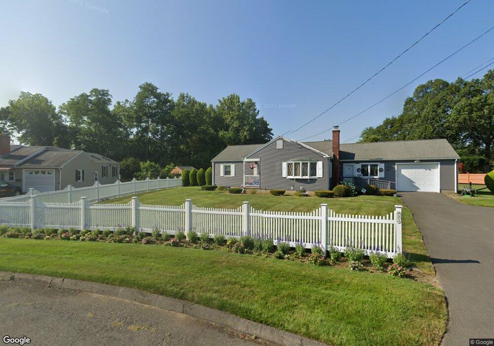
21 George Rd Windsor Locks, CT 06096
Estimated Value: $334,000 - $361,000
3
Beds
2
Baths
1,408
Sq Ft
$249/Sq Ft
Est. Value
About This Home
This home is located at 21 George Rd, Windsor Locks, CT 06096 and is currently estimated at $350,036, approximately $248 per square foot. 21 George Rd is a home located in Hartford County with nearby schools including North Street School, South Elementary School, and Windsor Locks Middle School.
Ownership History
Date
Name
Owned For
Owner Type
Purchase Details
Closed on
Aug 29, 1996
Sold by
Mastrangelo Edward
Bought by
Merritt Julie
Current Estimated Value
Home Financials for this Owner
Home Financials are based on the most recent Mortgage that was taken out on this home.
Original Mortgage
$59,600
Outstanding Balance
$4,783
Interest Rate
8.38%
Mortgage Type
Unknown
Estimated Equity
$345,253
Create a Home Valuation Report for This Property
The Home Valuation Report is an in-depth analysis detailing your home's value as well as a comparison with similar homes in the area
Home Values in the Area
Average Home Value in this Area
Purchase History
| Date | Buyer | Sale Price | Title Company |
|---|---|---|---|
| Merritt Julie | $74,500 | -- |
Source: Public Records
Mortgage History
| Date | Status | Borrower | Loan Amount |
|---|---|---|---|
| Open | Merritt Julie | $59,600 | |
| Previous Owner | Merritt Julie | $46,000 |
Source: Public Records
Tax History
| Year | Tax Paid | Tax Assessment Tax Assessment Total Assessment is a certain percentage of the fair market value that is determined by local assessors to be the total taxable value of land and additions on the property. | Land | Improvement |
|---|---|---|---|---|
| 2025 | $5,495 | $229,040 | $61,600 | $167,440 |
| 2024 | $3,855 | $136,990 | $49,700 | $87,290 |
| 2023 | $3,607 | $136,990 | $49,700 | $87,290 |
| 2022 | $3,538 | $136,990 | $49,700 | $87,290 |
| 2021 | $3,538 | $136,990 | $49,700 | $87,290 |
| 2020 | $3,538 | $136,990 | $49,700 | $87,290 |
| 2019 | $3,538 | $136,990 | $49,700 | $87,290 |
| 2017 | $3,183 | $119,400 | $47,000 | $72,400 |
| 2016 | $3,183 | $119,400 | $47,000 | $72,400 |
| 2015 | $3,199 | $119,400 | $47,000 | $72,400 |
| 2014 | $3,698 | $141,000 | $53,200 | $87,800 |
Source: Public Records
Map
Nearby Homes
- 32 Walnut Cir
- 11 Concorde Way Unit B2
- 10 Helena Ln
- 30 Jackson St
- 443 Elm St
- 94 Raymond Rd
- 1946 Poquonock Ave
- 4 Woodland Hollow St
- 404 Woodland St
- 24 Bel-Aire Cir
- 109 Old Village Cir
- 124 Bel-Aire Cir
- 58 High Path Rd Unit 58
- 98 High Path Rd
- 118 High Path Rd Unit 118
- 25 High St
- 136 High Path Rd
- 943 High Path Rd Unit 943
- 59 Elm St
- 268 High Path Rd Unit 268
- 25 George Rd
- 17 George Rd
- 300 Old County Rd
- 298 Old County Rd
- 29 George Rd
- 294 Old County Rd
- 24 George Rd
- 11 George Rd
- 304 Old County Rd
- 290 Old County Rd
- 16 George Rd
- 300 Southwest Ave Unit 3
- 300 Southwest Ave Unit 15
- 300 Southwest Ave Unit 6
- 300 Southwest Ave Unit 8
- 300 Southwest Ave Unit 7
- 300 Southwest Ave Unit 9
- 300 Southwest Ave Unit 19
- 300 Southwest Ave Unit 14-21
- 300 Southwest Ave Unit 10
Your Personal Tour Guide
Ask me questions while you tour the home.