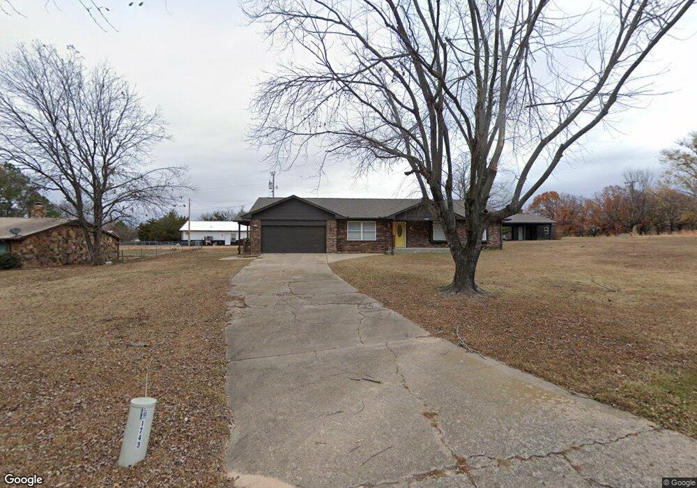
21 Hc 62 Eufaula, OK 74432
Estimated Value: $234,000 - $287,000
3
Beds
2
Baths
1,540
Sq Ft
$167/Sq Ft
Est. Value
About This Home
This home is located at 21 Hc 62, Eufaula, OK 74432 and is currently estimated at $257,591, approximately $167 per square foot. 21 Hc 62 is a home located in McIntosh County with nearby schools including Eufaula Elementary School, Eufaula Middle School, and Eufaula High School.
Ownership History
Date
Name
Owned For
Owner Type
Purchase Details
Closed on
Mar 22, 2024
Sold by
Larry And Linda Green 2017 Revocable Tru
Bought by
Deep Fork Community Action Foundation Inc
Current Estimated Value
Purchase Details
Closed on
Aug 27, 2021
Sold by
Green Linda
Bought by
Green Larry and Green Linda
Purchase Details
Closed on
Aug 18, 2021
Sold by
Slater Ann
Bought by
Green Linda
Purchase Details
Closed on
Nov 14, 2013
Sold by
Sharp Darren R and Sharp Shelley
Bought by
Slater Ann
Purchase Details
Closed on
Aug 8, 2007
Sold by
Citizens Security Bank And Trust Co
Bought by
Sharp Darren R and Sharp Shelley D
Home Financials for this Owner
Home Financials are based on the most recent Mortgage that was taken out on this home.
Original Mortgage
$99,000
Interest Rate
6.69%
Mortgage Type
New Conventional
Purchase Details
Closed on
May 24, 2007
Sold by
Smith Michale George and Smith Sandra Lynn
Bought by
Security Bank Ard Trust Co
Create a Home Valuation Report for This Property
The Home Valuation Report is an in-depth analysis detailing your home's value as well as a comparison with similar homes in the area
Home Values in the Area
Average Home Value in this Area
Purchase History
| Date | Buyer | Sale Price | Title Company |
|---|---|---|---|
| Deep Fork Community Action Foundation Inc | $240,000 | None Listed On Document | |
| Green Larry | -- | None Available | |
| Green Linda | $160,000 | Sovereign Title Services | |
| Slater Ann | $115,000 | -- | |
| Sharp Darren R | $99,000 | None Available | |
| Security Bank Ard Trust Co | -- | None Available |
Source: Public Records
Mortgage History
| Date | Status | Borrower | Loan Amount |
|---|---|---|---|
| Previous Owner | Sharp Darren R | $99,000 |
Source: Public Records
Tax History Compared to Growth
Tax History
| Year | Tax Paid | Tax Assessment Tax Assessment Total Assessment is a certain percentage of the fair market value that is determined by local assessors to be the total taxable value of land and additions on the property. | Land | Improvement |
|---|---|---|---|---|
| 2024 | -- | $0 | $0 | $0 |
| 2023 | $1,494 | $17,972 | $1,535 | $16,437 |
| 2022 | $1,491 | $17,972 | $1,535 | $16,437 |
| 2021 | $1,187 | $14,144 | $1,535 | $12,609 |
| 2020 | $1,188 | $14,144 | $1,535 | $12,609 |
| 2019 | $1,199 | $14,153 | $1,535 | $12,618 |
| 2018 | $1,178 | $14,152 | $1,535 | $12,617 |
| 2017 | $1,169 | $14,035 | $1,535 | $12,500 |
| 2016 | $1,119 | $13,367 | $1,535 | $11,832 |
| 2015 | $1,051 | $12,730 | $1,535 | $11,195 |
| 2014 | $1,044 | $12,730 | $1,535 | $11,195 |
Source: Public Records
Map
Nearby Homes
- 1812 Sunset Dr
- 2 Coon Creek Dr
- 9 Coon Creek Dr
- 3 Coon Creek Dr
- 7 Coon Creek Dr
- 123 Coon Creek Dr
- 1747 Mcgill Cir
- 1781 E Mcgill
- 1931 Coon Creek Dr
- 1831 Rockford Dr
- 1879 Rockford Dr
- 1826 W Mcgill Cir
- 1701 Mcgill Cir
- 416144 E 1170 Rd
- 1791 W Mcgill Cir
- 2011 E Rainbow Bend
- 3 Coon Creek Rd
- 15 Quail Dr
- 14 Quail Dr
- 17 Quail Dr
- 1826 Coon Creek Dr
- 1808 Coon Creek Dr
- 1821 Coon Creek Dr
- 1821 Coon Creek Dr
- 0 Coon Creek Dr Unit 2037663
- 1810 Coon Creek Dr
- 1810 Coon Creek Dr
- 1810 Coon Creek Dr
- 1810 Coon Creek Dr
- 0 Sunset Dr
- 52 Sunset Dr
- 58 Sunset Dr
- 1302 Coon Creek Rd
- 0 Coon Creek Unit 2236363
- 9 Coon Creek Rd
- 1842 Sunset Dr
- 1601 Coon Creek Rd
- 1705 Lakeview Dr
- 1704 Lakeview Dr
- 1707 Lakeview Dr