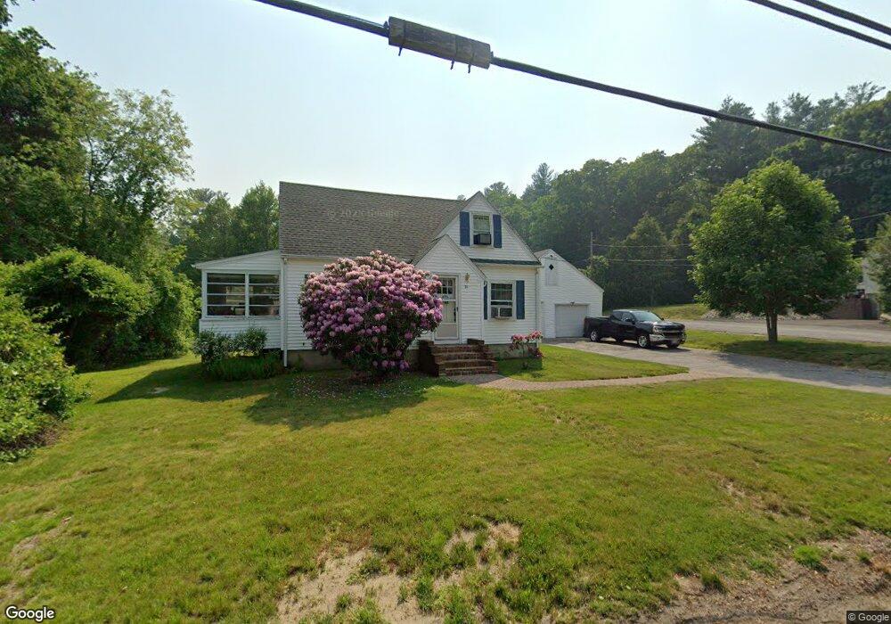
21 Highland St Whitinsville, MA 01588
Estimated Value: $425,000 - $504,000
2
Beds
1
Bath
1,464
Sq Ft
$314/Sq Ft
Est. Value
About This Home
This home is located at 21 Highland St, Whitinsville, MA 01588 and is currently estimated at $459,458, approximately $313 per square foot. 21 Highland St is a home located in Worcester County with nearby schools including Northbridge Elementary School, Northbridge Middle School, and Northbridge High School.
Ownership History
Date
Name
Owned For
Owner Type
Purchase Details
Closed on
Oct 1, 2001
Sold by
Livt Donald A Bousquet and Obrien Maryjane B
Bought by
Morais John C
Current Estimated Value
Purchase Details
Closed on
Feb 16, 2001
Sold by
Modar Jon E and Schattemen Christa
Bought by
Deiana Tina and Brenn Thomas
Home Financials for this Owner
Home Financials are based on the most recent Mortgage that was taken out on this home.
Original Mortgage
$173,900
Interest Rate
7.08%
Mortgage Type
Purchase Money Mortgage
Purchase Details
Closed on
May 26, 2000
Sold by
Obrien Mary Jane B and Bousquet Patrick E
Bought by
Mooar Jon E and Schatteman Christa
Home Financials for this Owner
Home Financials are based on the most recent Mortgage that was taken out on this home.
Original Mortgage
$150,000
Interest Rate
8.1%
Mortgage Type
Purchase Money Mortgage
Create a Home Valuation Report for This Property
The Home Valuation Report is an in-depth analysis detailing your home's value as well as a comparison with similar homes in the area
Home Values in the Area
Average Home Value in this Area
Purchase History
| Date | Buyer | Sale Price | Title Company |
|---|---|---|---|
| Morais John C | $64,500 | -- | |
| Morais John C | $64,500 | -- | |
| Deiana Tina | $183,900 | -- | |
| Deiana Tina | $183,900 | -- | |
| Mooar Jon E | $168,500 | -- | |
| Mooar Jon E | $168,500 | -- |
Source: Public Records
Mortgage History
| Date | Status | Borrower | Loan Amount |
|---|---|---|---|
| Previous Owner | Mooar Jon E | $173,900 | |
| Previous Owner | Mooar Jon E | $150,000 |
Source: Public Records
Tax History Compared to Growth
Tax History
| Year | Tax Paid | Tax Assessment Tax Assessment Total Assessment is a certain percentage of the fair market value that is determined by local assessors to be the total taxable value of land and additions on the property. | Land | Improvement |
|---|---|---|---|---|
| 2025 | $4,042 | $342,800 | $151,700 | $191,100 |
| 2024 | $3,889 | $321,700 | $151,700 | $170,000 |
| 2023 | $3,970 | $306,300 | $151,700 | $154,600 |
| 2022 | $3,555 | $258,200 | $116,700 | $141,500 |
| 2021 | $3,466 | $239,200 | $111,100 | $128,100 |
| 2020 | $492 | $233,800 | $111,100 | $122,700 |
| 2019 | $473 | $225,800 | $111,100 | $114,700 |
| 2018 | $6,016 | $215,200 | $105,700 | $109,500 |
| 2017 | $2,805 | $207,300 | $105,700 | $101,600 |
| 2016 | $2,636 | $191,700 | $96,100 | $95,600 |
| 2015 | $2,565 | $191,700 | $96,100 | $95,600 |
| 2014 | $2,542 | $191,700 | $96,100 | $95,600 |
Source: Public Records
Map
Nearby Homes
- 140 Rolling Ridge Dr Unit 78
- 1052 Providence Rd
- 33 Crestwood Cir Unit 45
- 169 Rolling Ridge Dr Unit 97
- 39 Crestwood Cir Unit 42
- 159 Rolling Ridge Dr Unit 85
- 157 Rolling Ridge Dr Unit 84
- 5 Summit St
- 894 Marston Rd
- 21 Granite St
- 831 Providence Rd Unit 837
- 708 Marston Rd
- 121 East St Unit 121
- 90 Nathaniel Dr
- 18 East St Unit 24
- Lots 1-9 Spring St
- 192 Rebecca Rd
- 128 Linwood Ave
- 46 Rebecca Rd
- 86 Kingsnorth St
- 607 Church St Unit 609
- 35 Highland St
- 627 Church St
- 10 Delray Gardens
- 32 Highland St
- 45 Highland St
- 601 Church St Unit 603
- 16 Delray Gardens
- 40 Highland St
- 19 Delray Gardens
- 639 Church St
- 645 Church St
- 602 Church St
- 614 Church St
- 608 Church St
- 632 Church St
- 18 Delray Gardens
- 589 Church St Unit 591
- 48 Highland St Unit 50
- 640 Church St Unit 642