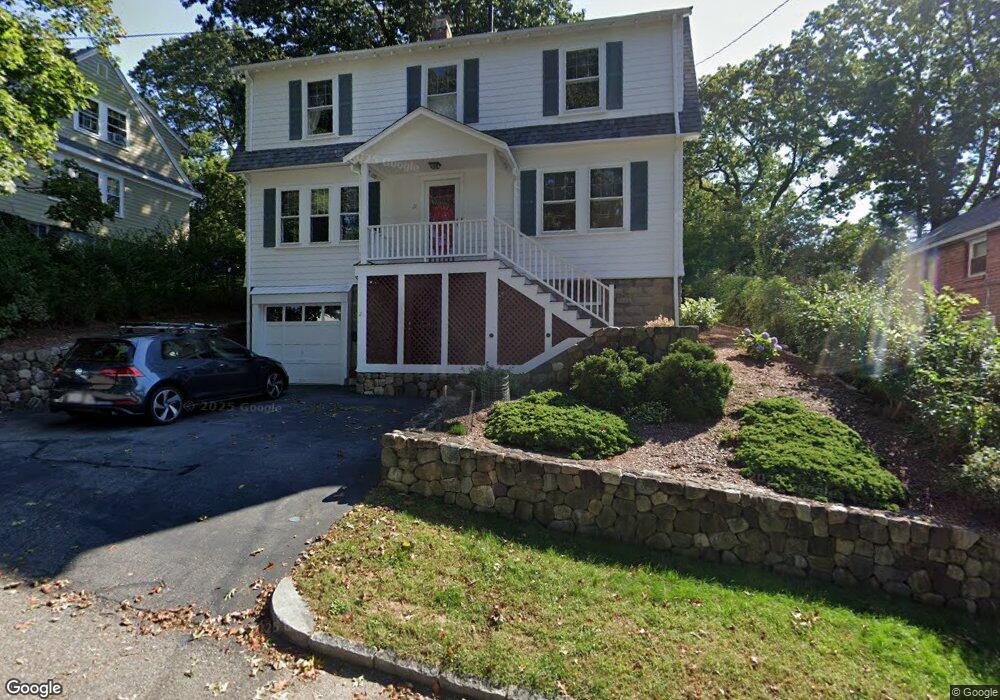
21 Lansdowne Rd Arlington, MA 02474
Arlington Heights NeighborhoodEstimated Value: $1,068,000 - $1,307,726
4
Beds
3
Baths
2,178
Sq Ft
$557/Sq Ft
Est. Value
About This Home
This home is located at 21 Lansdowne Rd, Arlington, MA 02474 and is currently estimated at $1,213,432, approximately $557 per square foot. 21 Lansdowne Rd is a home located in Middlesex County with nearby schools including M. Norcross Stratton Elementary School, Ottoson Middle School, and Arlington High School.
Ownership History
Date
Name
Owned For
Owner Type
Purchase Details
Closed on
Aug 24, 2021
Sold by
Meadow-Atlas Linda and Atlas Michael
Bought by
Linda & Michael Atlas Ft and Atlas
Current Estimated Value
Purchase Details
Closed on
Sep 1, 1979
Bought by
Meadow-Atlas Linda and Atlas Michael
Create a Home Valuation Report for This Property
The Home Valuation Report is an in-depth analysis detailing your home's value as well as a comparison with similar homes in the area
Home Values in the Area
Average Home Value in this Area
Purchase History
| Date | Buyer | Sale Price | Title Company |
|---|---|---|---|
| Linda & Michael Atlas Ft | -- | None Available | |
| Meadow-Atlas Linda | $68,500 | -- |
Source: Public Records
Mortgage History
| Date | Status | Borrower | Loan Amount |
|---|---|---|---|
| Previous Owner | Meadow-Atlas Linda | $100,000 | |
| Previous Owner | Meadow-Atlas Linda | $44,250 |
Source: Public Records
Tax History
| Year | Tax Paid | Tax Assessment Tax Assessment Total Assessment is a certain percentage of the fair market value that is determined by local assessors to be the total taxable value of land and additions on the property. | Land | Improvement |
|---|---|---|---|---|
| 2025 | $10,559 | $980,400 | $507,800 | $472,600 |
| 2024 | $10,000 | $944,300 | $501,700 | $442,600 |
| 2023 | $9,594 | $855,800 | $452,100 | $403,700 |
| 2022 | $9,129 | $799,400 | $433,500 | $365,900 |
| 2021 | $8,939 | $788,300 | $433,500 | $354,800 |
| 2020 | $8,720 | $788,400 | $433,500 | $354,900 |
| 2019 | $7,910 | $702,500 | $439,700 | $262,800 |
| 2018 | $7,169 | $591,000 | $328,200 | $262,800 |
| 2017 | $7,035 | $560,100 | $297,300 | $262,800 |
| 2016 | $7,011 | $547,700 | $284,900 | $262,800 |
| 2015 | $6,741 | $497,500 | $241,500 | $256,000 |
Source: Public Records
Map
Nearby Homes
- 52-56 Dudley St
- 33 Dickson Ave
- 995 Massachusetts Ave Unit 404
- 1025 Massachusetts Ave Unit 304
- 1025 Massachusetts Ave Unit 211
- 1025 Massachusetts Ave Unit 409
- 1025 Massachusetts Ave Unit 214
- 1025 Massachusetts Ave Unit 213
- 92 Overlook Rd
- 990 Mass Ave Unit E80
- 455-457 Summer St
- 455 Summer St Unit 455
- 15 Higgins St Unit 17
- 39 Forest St Unit 39A
- 4 Beck Rd
- 15 College Ave
- 66 Hutchinson Rd
- 259 Mystic St
- 11 Lowell St Unit B
- 33 Harvard St
- 29 Lansdowne Rd
- 19 Lansdowne Rd Unit 19
- 33 Lansdowne Rd
- 15 Lansdowne Rd
- 26 Lansdowne Rd
- 16 Lansdowne Rd
- 11 Lansdowne Rd
- 30 Lansdowne Rd
- 11 Rockland Ave
- 12 Lansdowne Rd
- 7 Lansdowne Rd
- 17 Rockland Ave
- 5 Rockland Ave
- 8 Lansdowne Rd
- 7 Janet Rd
- 34 Lansdowne Rd
- 11 Janet Rd
- 69 Hemlock St
- 43 Millett St
- 73 Hemlock St
Your Personal Tour Guide
Ask me questions while you tour the home.