
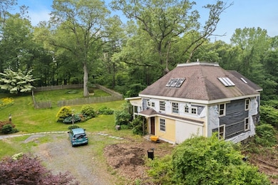
21 Main St Byfield, MA 01922
Estimated payment $7,214/month
Highlights
- 4.1 Acre Lot
- Wooded Lot
- No HOA
About This Lot
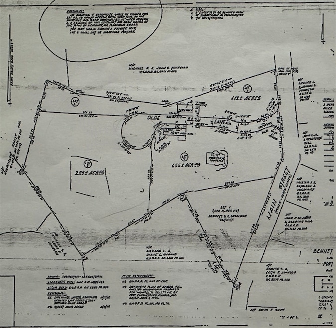
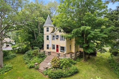
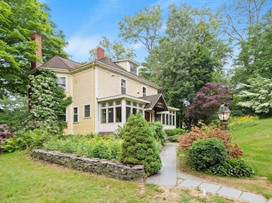
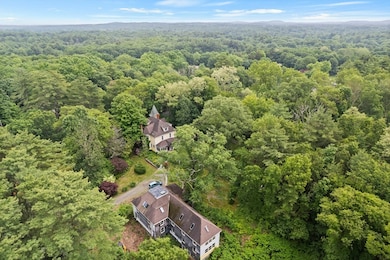
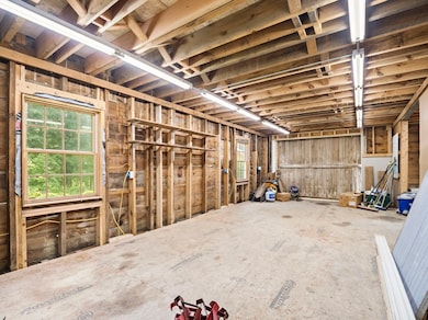
Builders take notice!! Over 4 acres of land!! Charming Victorian Home with Barn & Buildable Lot in scenic Newbury. Welcome to 21 Main Street, a timeless Victorian gem nestled in the heart of Newbury. Set on over 1.5 acres of beautiful grounds, this gracious residence also includes an additional 2.5-acre buildable lot, offering a rare opportunity for expansion, investment, or multi-generational living. Steeped in character and rich with history, this elegant home showcases classic period details throughout intricate moldings, soaring ceilings, original hardwood floors, and ornate fireplaces that serve as focal points in several rooms. The spacious layout offers the perfect blend of formal and casual living spaces, ideal for entertaining or relaxing in old-world charm. Outside, a separate barn with heat and electricity, provides exceptional space for a workshop, studio, additional storage, potential in-law or Accessory Dwelling Unit. Close proximity to route 95 and Plum Island!
Property Details
Property Type
- Land
Est. Annual Taxes
- $8,545
Lot Details
- 4.1 Acre Lot
- Wooded Lot
- Property is zoned AR4
Utilities
- Electricity To Lot Line
Community Details
- No Home Owners Association
Listing and Financial Details
- Assessor Parcel Number M:0R19 B:0000 L:0054B
Map
Home Values in the Area
Average Home Value in this Area
Tax History
| Year | Tax Paid | Tax Assessment Tax Assessment Total Assessment is a certain percentage of the fair market value that is determined by local assessors to be the total taxable value of land and additions on the property. | Land | Improvement |
|---|---|---|---|---|
| 2025 | $8,545 | $1,147,000 | $423,400 | $723,600 |
| 2024 | $8,274 | $1,077,400 | $378,600 | $698,800 |
| 2023 | $8,869 | $1,022,900 | $324,100 | $698,800 |
| 2022 | $8,623 | $886,200 | $291,400 | $594,800 |
| 2021 | $8,174 | $766,800 | $226,100 | $540,700 |
| 2020 | $8,107 | $737,700 | $226,100 | $511,600 |
| 2019 | $7,649 | $707,600 | $204,300 | $503,300 |
| 2018 | $7,350 | $674,300 | $204,300 | $470,000 |
| 2017 | $7,154 | $674,300 | $204,300 | $470,000 |
| 2016 | $6,542 | $573,900 | $160,800 | $413,100 |
| 2015 | $6,486 | $563,000 | $149,900 | $413,100 |
| 2014 | $6,365 | $562,300 | $149,900 | $412,400 |
Property History
| Date | Event | Price | List to Sale | Price per Sq Ft |
|---|---|---|---|---|
| 07/23/2025 07/23/25 | Price Changed | $1,235,000 | -14.8% | -- |
| 06/17/2025 06/17/25 | For Sale | $1,449,900 | -- | -- |
Purchase History
| Date | Type | Sale Price | Title Company |
|---|---|---|---|
| Quit Claim Deed | -- | -- | |
| Quit Claim Deed | -- | -- |
Mortgage History
| Date | Status | Loan Amount | Loan Type |
|---|---|---|---|
| Open | $269,208 | New Conventional | |
| Previous Owner | $322,700 | No Value Available |
Source: MLS Property Information Network (MLS PIN)
MLS Number: 73392125
APN: NEWB-000019R-000000-000054B
Disclaimer: Certain information contained herein is derived from information provided by parties other than Homes.com. All information provided is deemed reliable, but is not guaranteed to be accurate and should be independently verified.
![]() The property listing data and information, or the Images, set forth herein were provided to MLS Property Information Network, Inc. from third party sources, including sellers, lessors and public records, and were compiled by MLS Property Information Network, Inc. The property listing data and information, and the Images, are for the personal, non-commercial use of consumers having a good faith interest in purchasing or leasing listed properties of the type displayed to them and may not be used for any purpose other than to identify prospective properties which such consumers may have a good faith interest in purchasing or leasing. MLS Property Information Network, Inc. and its subscribers disclaim any and all representations and warranties as to the accuracy of the property listing data and information, or as to the accuracy of any of the Images, set forth herein.
The property listing data and information, or the Images, set forth herein were provided to MLS Property Information Network, Inc. from third party sources, including sellers, lessors and public records, and were compiled by MLS Property Information Network, Inc. The property listing data and information, and the Images, are for the personal, non-commercial use of consumers having a good faith interest in purchasing or leasing listed properties of the type displayed to them and may not be used for any purpose other than to identify prospective properties which such consumers may have a good faith interest in purchasing or leasing. MLS Property Information Network, Inc. and its subscribers disclaim any and all representations and warranties as to the accuracy of the property listing data and information, or as to the accuracy of any of the Images, set forth herein.
- 15 Knobb Hill
- 66 Parish Rd Unit 4
- 6 Parker River Dr
- 4 Swanton Way
- 10 Noyes Rd
- 18 Forest St
- 15 Central St
- 34 Central St
- 5 Charles St
- 30 Forest St
- 66 3 Parish Rd
- 55 Pearson Dr Unit 9 - ALDER
- 55 Pearson Dr Unit 6-Dogwood
- 55 Pearson Dr Unit 3 - ALDER
- 55 Pearson Dr Unit 8-Dogwood
- 66 2 Parish Rd
- 15 School St
- 111 Moulton St
- 2 & 4 Tenney Ct
- 4 Coleman Rd
- 123 Central St Unit 6
- 803 Haverhill St Unit 2-A6
- 870 Haverhill St Unit 11C
- 862 Haverhill St Unit 15
- 1 Manor Dr
- 888 Salem St
- 178 Storey Ave
- 1 Boston Way
- 232 Low St Unit 6
- 12 Hines Way Unit 12
- 234 Low St Unit 3
- 21 Hines Way Unit 21
- 71 Keeley St
- 126 High St Unit 1
- 47 High St
- 33 Merrill St Unit 3
- 33 Woodland St Unit 1
- 7 Horton St Unit 7
- 7 Summer St Unit 7
- 59 Prospect St Unit 1
