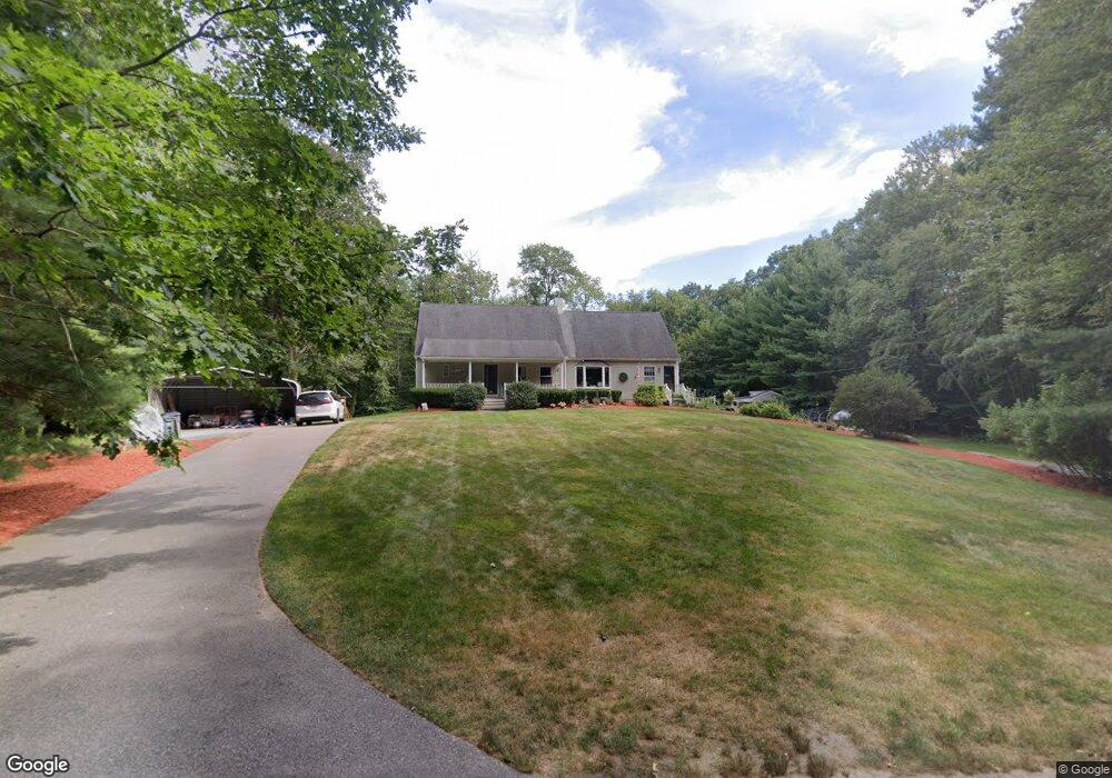
21 Maple Ln Rehoboth, MA 02769
Estimated Value: $796,000 - $989,000
3
Beds
3
Baths
2,639
Sq Ft
$330/Sq Ft
Est. Value
About This Home
This home is located at 21 Maple Ln, Rehoboth, MA 02769 and is currently estimated at $871,480, approximately $330 per square foot. 21 Maple Ln is a home located in Bristol County with nearby schools including Dighton-Rehoboth Regional High School.
Ownership History
Date
Name
Owned For
Owner Type
Purchase Details
Closed on
Mar 12, 2024
Sold by
Dumont Robert C
Bought by
Robert C Dumont 2021 Ret and Dumont
Current Estimated Value
Purchase Details
Closed on
Jun 15, 2001
Sold by
Marchand Kenneth R and Marchand Anna M
Bought by
Dumont Robert C and Dumont Nancy J
Home Financials for this Owner
Home Financials are based on the most recent Mortgage that was taken out on this home.
Original Mortgage
$240,000
Interest Rate
7.15%
Mortgage Type
Purchase Money Mortgage
Create a Home Valuation Report for This Property
The Home Valuation Report is an in-depth analysis detailing your home's value as well as a comparison with similar homes in the area
Home Values in the Area
Average Home Value in this Area
Purchase History
| Date | Buyer | Sale Price | Title Company |
|---|---|---|---|
| Robert C Dumont 2021 Ret | -- | None Available | |
| Dumont Robert C | $340,000 | -- |
Source: Public Records
Mortgage History
| Date | Status | Borrower | Loan Amount |
|---|---|---|---|
| Previous Owner | Dumont Robert C | $240,000 | |
| Previous Owner | Dumont Robert C | $16,528 | |
| Previous Owner | Dumont Robert C | $170,400 |
Source: Public Records
Tax History Compared to Growth
Tax History
| Year | Tax Paid | Tax Assessment Tax Assessment Total Assessment is a certain percentage of the fair market value that is determined by local assessors to be the total taxable value of land and additions on the property. | Land | Improvement |
|---|---|---|---|---|
| 2025 | $83 | $741,500 | $197,700 | $543,800 |
| 2024 | $7,662 | $674,500 | $197,700 | $476,800 |
| 2023 | $7,058 | $667,700 | $193,700 | $474,000 |
| 2022 | $7,058 | $557,100 | $185,300 | $371,800 |
| 2021 | $7,208 | $544,400 | $169,000 | $375,400 |
| 2020 | $6,990 | $532,800 | $169,000 | $363,800 |
| 2018 | $5,319 | $444,400 | $161,200 | $283,200 |
| 2017 | $5,143 | $409,500 | $161,200 | $248,300 |
| 2016 | $4,848 | $399,000 | $161,200 | $237,800 |
| 2015 | $5,089 | $413,400 | $154,000 | $259,400 |
| 2014 | $4,839 | $389,000 | $146,800 | $242,200 |
Source: Public Records
Map
Nearby Homes
- 20 Taylor Dr
- 0 Horton St Unit 73333337
- 24 New St
- 133 Winthrop St
- 2661 Horton St
- 105 Winthrop St
- 225 Winthrop St
- 28 Bucklin Dr
- Lot 7 Muriel Way
- 1030 Oak St
- 43 Williams St
- 246 Winthrop St
- 0 Winthrop St Unit 73180872
- 63 Moulton St
- 29 Moulton St
- 257 Anawan St
- 1240 Smith St
- 134 Bay State Rd
- 216 Anawan St
- 2043 Wellington St
- 15 Maple Ln
- 25 Maple Ln
- 16 Maple Ln
- 30 Maple Ln
- 11 Maple Ln
- 29 Maple Ln
- 10 Maple Ln
- 7 Maple Ln
- 34 Maple Ln
- 22 Maple Ln
- 26 Maple Ln
- 41 Maple Ln
- 40 Maple Ln
- 45 Maple Ln
- 51 Maple Ln
- 0 Maple Lane L-17a Unit 50491783
- 0 Maple Lane L-M41 P-17d Unit 50491784
- 0 Maple Lane L-7e Unit 50491781
- 48 Maple Ln
- 52 Maple Ln