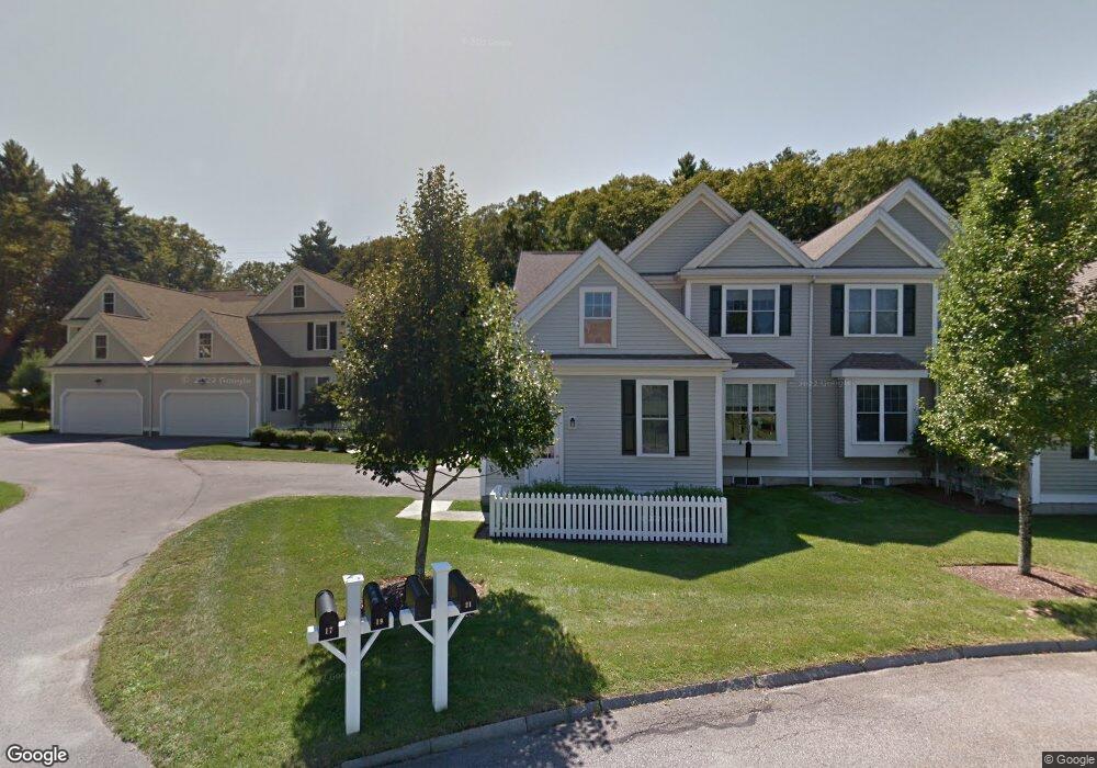
21 Margauxs Way Norfolk, MA 02056
Estimated Value: $706,000 - $794,000
2
Beds
3
Baths
2,372
Sq Ft
$311/Sq Ft
Est. Value
About This Home
This home is located at 21 Margauxs Way, Norfolk, MA 02056 and is currently estimated at $737,204, approximately $310 per square foot. 21 Margauxs Way is a home located in Norfolk County with nearby schools including H. Olive Day School, Freeman-Kennedy School, and Woodside Montessori Academy.
Ownership History
Date
Name
Owned For
Owner Type
Purchase Details
Closed on
Jun 8, 2021
Sold by
Jones Nancy S
Bought by
Nancy S Jones Ret
Current Estimated Value
Purchase Details
Closed on
Dec 11, 2018
Sold by
Jones Nancy S
Bought by
Nancy S Jones Ret
Purchase Details
Closed on
Dec 1, 2011
Sold by
Orecchio Ft and Orecchio John J
Bought by
Jones Philip E and Jones Nancy S
Purchase Details
Closed on
Jul 10, 2006
Sold by
Orecchio John J and Orecchio Anne D
Bought by
Orecchio John J and Orecchio Anne D
Purchase Details
Closed on
Jun 29, 2004
Sold by
Holbrook Common Norfol
Bought by
Orecchio Anne D and Orecchio John J
Create a Home Valuation Report for This Property
The Home Valuation Report is an in-depth analysis detailing your home's value as well as a comparison with similar homes in the area
Home Values in the Area
Average Home Value in this Area
Purchase History
| Date | Buyer | Sale Price | Title Company |
|---|---|---|---|
| Nancy S Jones Ret | -- | None Available | |
| Nancy S Jones Ret | -- | -- | |
| Jones Philip E | $382,000 | -- | |
| Orecchio John J | -- | -- | |
| Orecchio Anne D | $476,855 | -- |
Source: Public Records
Tax History Compared to Growth
Tax History
| Year | Tax Paid | Tax Assessment Tax Assessment Total Assessment is a certain percentage of the fair market value that is determined by local assessors to be the total taxable value of land and additions on the property. | Land | Improvement |
|---|---|---|---|---|
| 2025 | $9,766 | $611,500 | $0 | $611,500 |
| 2024 | $9,345 | $600,200 | $0 | $600,200 |
| 2023 | $9,298 | $566,600 | $0 | $566,600 |
| 2022 | $8,654 | $475,500 | $0 | $475,500 |
| 2021 | $9,152 | $508,700 | $0 | $508,700 |
| 2020 | $8,561 | $459,300 | $0 | $459,300 |
| 2019 | $8,492 | $464,300 | $0 | $464,300 |
| 2018 | $7,569 | $406,500 | $0 | $406,500 |
| 2017 | $7,487 | $410,900 | $0 | $410,900 |
| 2016 | $7,283 | $402,800 | $0 | $402,800 |
| 2015 | $7,329 | $415,000 | $0 | $415,000 |
| 2014 | $7,310 | $419,400 | $0 | $419,400 |
Source: Public Records
Map
Nearby Homes
- 29 Wildwood Rd Unit 29
- 98 Myrtle St
- 1 Granite Dr
- 12 Ariana Ln
- 48 River Rd
- 145 Acorn St
- 10 Medway St
- 2 Gerald Ave
- 41 Myrtle St
- 27 Whichita Rd
- 292 Main St
- 23 Algonquin Rd
- 60 Spencer St
- 99 Leland Rd
- 16 Keeney Pond Rd
- 10 Populatic Street Extension
- 16 Lexington Ln
- 18 Keeney Pond Rd
- 7 Malcolm St
- 10 Silver Fox Rd
- 15 Lois Ln
- 11 Lois Ln
- 2 Margauxs Way
- 6 Margauxs Way
- 14 Margauxs Way
- 4 Wildwood Rd
- 1 Wildwood Rd
- 39 Lois Ln
- 35 Lois Ln
- 29 Lois Ln
- 23 Lois Ln
- 19 Lois Ln
- 5 Lois Ln
- 3 Lois Ln
- 21 Margauxs Way Unit Lot 31
- 6 Margauxs Way Unit Lot 3
- 17 Lois Ln
- 15 Margauxs Way
- 15 Margauxs Way Unit 15
- 15 Margauxs Way Unit Lot 34