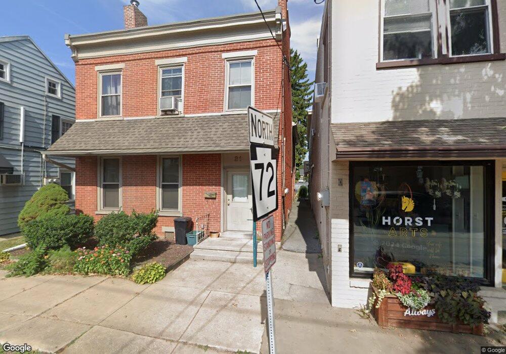
21 N Main St Manheim, PA 17545
Estimated Value: $393,000 - $431,000
4
Beds
3
Baths
3,148
Sq Ft
$132/Sq Ft
Est. Value
About This Home
This home is located at 21 N Main St, Manheim, PA 17545 and is currently estimated at $417,044, approximately $132 per square foot. 21 N Main St is a home located in Lancaster County with nearby schools including Manheim Central Senior High School, Manheim Christian Day School, and Sporting Hill Christian School.
Ownership History
Date
Name
Owned For
Owner Type
Purchase Details
Closed on
Aug 25, 2022
Sold by
Barto Shawn M
Bought by
Dietrich Matthew A and Dietrich Taylar L
Current Estimated Value
Home Financials for this Owner
Home Financials are based on the most recent Mortgage that was taken out on this home.
Original Mortgage
$284,000
Outstanding Balance
$271,884
Interest Rate
5.51%
Mortgage Type
New Conventional
Estimated Equity
$145,160
Purchase Details
Closed on
Jan 21, 1999
Sold by
Barto Shawn M
Bought by
Barto Shawn M and Barto Lisa M
Home Financials for this Owner
Home Financials are based on the most recent Mortgage that was taken out on this home.
Original Mortgage
$101,250
Interest Rate
6.67%
Create a Home Valuation Report for This Property
The Home Valuation Report is an in-depth analysis detailing your home's value as well as a comparison with similar homes in the area
Home Values in the Area
Average Home Value in this Area
Purchase History
| Date | Buyer | Sale Price | Title Company |
|---|---|---|---|
| Dietrich Matthew A | $355,000 | None Listed On Document | |
| Barto Shawn M | -- | -- | |
| Barto Shawn M | -- | -- |
Source: Public Records
Mortgage History
| Date | Status | Borrower | Loan Amount |
|---|---|---|---|
| Open | Dietrich Matthew A | $284,000 | |
| Previous Owner | Barto Shawn M | $101,250 |
Source: Public Records
Tax History Compared to Growth
Tax History
| Year | Tax Paid | Tax Assessment Tax Assessment Total Assessment is a certain percentage of the fair market value that is determined by local assessors to be the total taxable value of land and additions on the property. | Land | Improvement |
|---|---|---|---|---|
| 2025 | $5,414 | $224,700 | $39,800 | $184,900 |
| 2024 | $5,414 | $224,700 | $39,800 | $184,900 |
| 2023 | $5,318 | $224,700 | $39,800 | $184,900 |
| 2022 | $5,146 | $224,700 | $39,800 | $184,900 |
| 2021 | $4,991 | $224,700 | $39,800 | $184,900 |
| 2020 | $4,991 | $224,700 | $39,800 | $184,900 |
| 2019 | $4,917 | $224,700 | $39,800 | $184,900 |
| 2018 | $3,220 | $224,700 | $39,800 | $184,900 |
| 2017 | $4,355 | $159,200 | $30,500 | $128,700 |
| 2016 | $4,228 | $159,200 | $30,500 | $128,700 |
| 2015 | $1,399 | $159,200 | $30,500 | $128,700 |
| 2014 | $2,736 | $159,200 | $30,500 | $128,700 |
Source: Public Records
Map
Nearby Homes
- 2 S Charlotte St
- 162 N Charlotte St
- 27 W Ferdinand St
- 28 N Grant St
- 108 110 S Main St
- 33 W Ferdinand St
- 37 W Ferdinand St
- 43 W Ferdinand St
- 188 N Main St
- 123 S Main St
- 125 S Main St
- 239 E High St
- 218 W Ferdinand St
- 113 S Grant St
- 140 S Charlotte St
- 121 Mill St
- 173 S Wolf St
- 32 S Fulton St
- 51 S Snyder St
- 120 Julia Ln
- 23 N Main St
- 25 N Main St
- 25 N Main St Unit 2ND FLOOR
- 15 N Main St
- 0 Glenwood Design Unit 1004730393
- 0 Glenwood Design Unit 1004725707
- 0 Glenwood Design Unit 1004612749
- 0 Glenwood Design Unit 1004606645
- 0 Glenwood Design Unit 1004558951
- 0 Glenwood Design Unit 1002802593
- 0 Glenwood Design Unit 134455
- 0 Glenwood Design Unit 142614
- 0 Glenwood Design Unit 145680
- 0 Glenwood Design Unit 163296
- 0 Glenwood Design Unit 172657
- 0 Glenwood Design Unit 188271
- 0 Glenwood Design Unit 196337
- 0 Glenwood Design Unit 222947
- 0 Glenwood Design Unit 238841
- 0 Glenwood Design Unit PALA146460