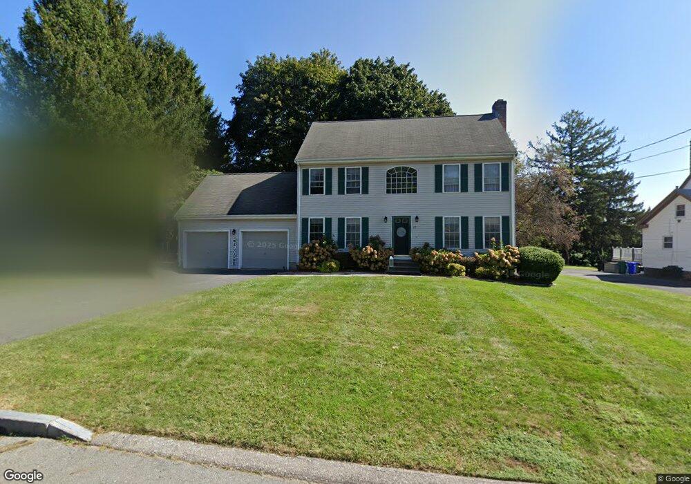
21 Nora Way Attleboro, MA 02703
Estimated Value: $623,000 - $716,000
3
Beds
3
Baths
1,728
Sq Ft
$387/Sq Ft
Est. Value
About This Home
This home is located at 21 Nora Way, Attleboro, MA 02703 and is currently estimated at $668,736, approximately $387 per square foot. 21 Nora Way is a home located in Bristol County with nearby schools including Hill-Roberts Elementary School, Robert J. Coelho Middle School, and Attleboro High School.
Ownership History
Date
Name
Owned For
Owner Type
Purchase Details
Closed on
May 24, 2001
Sold by
Baracewicz John J and Baracewicz Saundra A
Bought by
Bogacz Joseph C and Bogacz Josephine R
Current Estimated Value
Home Financials for this Owner
Home Financials are based on the most recent Mortgage that was taken out on this home.
Original Mortgage
$255,550
Outstanding Balance
$95,563
Interest Rate
7.05%
Mortgage Type
Purchase Money Mortgage
Estimated Equity
$573,173
Purchase Details
Closed on
Nov 4, 1997
Sold by
J Colella & Son Inc
Bought by
Baracewicz Saundra
Home Financials for this Owner
Home Financials are based on the most recent Mortgage that was taken out on this home.
Original Mortgage
$144,000
Interest Rate
7.31%
Mortgage Type
Purchase Money Mortgage
Create a Home Valuation Report for This Property
The Home Valuation Report is an in-depth analysis detailing your home's value as well as a comparison with similar homes in the area
Home Values in the Area
Average Home Value in this Area
Purchase History
| Date | Buyer | Sale Price | Title Company |
|---|---|---|---|
| Bogacz Joseph C | $269,000 | -- | |
| Baracewicz Saundra | $180,000 | -- |
Source: Public Records
Mortgage History
| Date | Status | Borrower | Loan Amount |
|---|---|---|---|
| Open | Baracewicz Saundra | $255,550 | |
| Previous Owner | Baracewicz Saundra | $162,000 | |
| Previous Owner | Baracewicz Saundra | $144,000 |
Source: Public Records
Tax History Compared to Growth
Tax History
| Year | Tax Paid | Tax Assessment Tax Assessment Total Assessment is a certain percentage of the fair market value that is determined by local assessors to be the total taxable value of land and additions on the property. | Land | Improvement |
|---|---|---|---|---|
| 2025 | $6,938 | $552,800 | $175,600 | $377,200 |
| 2024 | $6,993 | $549,300 | $193,200 | $356,100 |
| 2023 | $6,293 | $459,700 | $169,300 | $290,400 |
| 2022 | $5,864 | $405,800 | $149,500 | $256,300 |
| 2021 | $5,837 | $394,400 | $143,900 | $250,500 |
| 2020 | $5,546 | $380,900 | $136,500 | $244,400 |
| 2019 | $5,395 | $381,000 | $133,700 | $247,300 |
| 2018 | $5,221 | $352,300 | $129,900 | $222,400 |
| 2017 | $5,205 | $357,700 | $135,100 | $222,600 |
| 2016 | $5,030 | $339,400 | $126,200 | $213,200 |
| 2015 | $4,888 | $332,300 | $126,200 | $206,100 |
| 2014 | $4,823 | $324,800 | $121,300 | $203,500 |
Source: Public Records
Map
Nearby Homes
- 17 Lockwood Ave
- 543 Newport Ave
- 48 May St
- 130 Zoar Ave
- 23 Cumberland Ave
- 39 Slade Ave
- 44 Buffington St
- 96 Robinson Ave
- 0 Mendon Rd
- 59 Samuel Way
- 31 Carleton St
- 135 Cumberland Ave
- 30 Thomas Ave
- 193 Robinson Ave
- 143 Carrier Ave
- 980 Newport Ave
- 1 Frederick a Nittel Dr
- 139 Hackett Ave
- 276 Newport Ave
- 0 Middle St