Estimated Value: $895,014 - $942,000
4
Beds
2
Baths
1,760
Sq Ft
$518/Sq Ft
Est. Value
About This Home
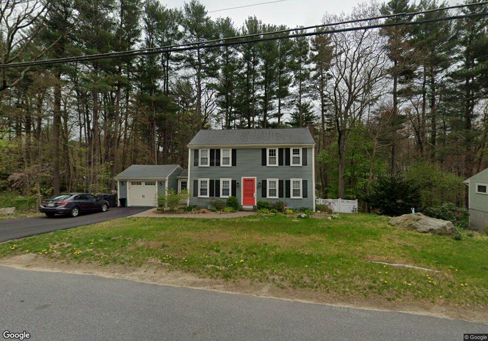
This home is located at 21 Oneida Rd, Acton, MA 01720 and is currently estimated at $912,254, approximately $518 per square foot. 21 Oneida Rd is a home located in Middlesex County with nearby schools including Acton-Boxborough Regional High School.
Ownership History
Date
Name
Owned For
Owner Type
Purchase Details
Closed on
Jul 1, 2022
Sold by
Brown Paul B and Brown Julie C
Bought by
Brown Ft and Brown
Current Estimated Value
Purchase Details
Closed on
Dec 4, 2013
Sold by
Jeong Soogil and Hong Heesun
Bought by
Brown Julie C and Brown Paul B
Home Financials for this Owner
Home Financials are based on the most recent Mortgage that was taken out on this home.
Original Mortgage
$451,668
Interest Rate
3.87%
Mortgage Type
FHA
Purchase Details
Closed on
Jul 22, 2004
Sold by
Jordan Ann L and Jordan John S
Bought by
Hong Heesun and Jeong Soogil
Home Financials for this Owner
Home Financials are based on the most recent Mortgage that was taken out on this home.
Original Mortgage
$363,000
Interest Rate
6.28%
Mortgage Type
Purchase Money Mortgage
Purchase Details
Closed on
May 4, 1987
Sold by
Shaughnessy Jean Q
Bought by
Labossiere Robt J
Create a Home Valuation Report for This Property
The Home Valuation Report is an in-depth analysis detailing your home's value as well as a comparison with similar homes in the area
Home Values in the Area
Average Home Value in this Area
Purchase History
| Date | Buyer | Sale Price | Title Company |
|---|---|---|---|
| Brown Ft | -- | None Available | |
| Brown Ft | -- | None Available | |
| Brown Julie C | $460,000 | -- | |
| Hong Heesun | $518,000 | -- | |
| Hong Heesun | $518,000 | -- | |
| Labossiere Robt J | $207,000 | -- |
Source: Public Records
Mortgage History
| Date | Status | Borrower | Loan Amount |
|---|---|---|---|
| Previous Owner | Brown Julie C | $451,668 | |
| Previous Owner | Hong Heesun | $363,000 |
Source: Public Records
Tax History
| Year | Tax Paid | Tax Assessment Tax Assessment Total Assessment is a certain percentage of the fair market value that is determined by local assessors to be the total taxable value of land and additions on the property. | Land | Improvement |
|---|---|---|---|---|
| 2025 | $13,061 | $761,600 | $318,500 | $443,100 |
| 2024 | $11,899 | $713,800 | $318,500 | $395,300 |
| 2023 | $11,590 | $660,000 | $289,500 | $370,500 |
| 2022 | $10,980 | $564,500 | $251,500 | $313,000 |
| 2021 | $10,716 | $529,700 | $233,100 | $296,600 |
| 2020 | $10,113 | $525,600 | $233,100 | $292,500 |
| 2019 | $9,480 | $489,400 | $233,100 | $256,300 |
| 2018 | $9,330 | $481,400 | $233,100 | $248,300 |
| 2017 | $9,156 | $480,400 | $233,100 | $247,300 |
| 2016 | $9,005 | $468,300 | $233,100 | $235,200 |
| 2015 | $7,980 | $418,900 | $233,100 | $185,800 |
| 2014 | $7,794 | $400,700 | $233,100 | $167,600 |
Source: Public Records
Map
Nearby Homes
- 60 Nashoba Rd
- 5 Perkins Ln
- 4 Littlefield Rd
- 79 Charter Rd
- 20 Joseph Reed Ln
- 235 Arlington St
- 18 Hayward Rd
- 4 Omega Way
- 246 Main St Unit 2
- 11 Braebrook
- 7 Kelley Rd
- 92 Willow St Unit 3
- 92 Willow St Unit 2
- 90 Willow St Unit 1
- 33 Meadowbrook Rd
- 46 Taylor Rd
- 184 Main St Unit 3
- 491 Main St
- 524 Main St
- 305 Harwood Ave
Your Personal Tour Guide
Ask me questions while you tour the home.