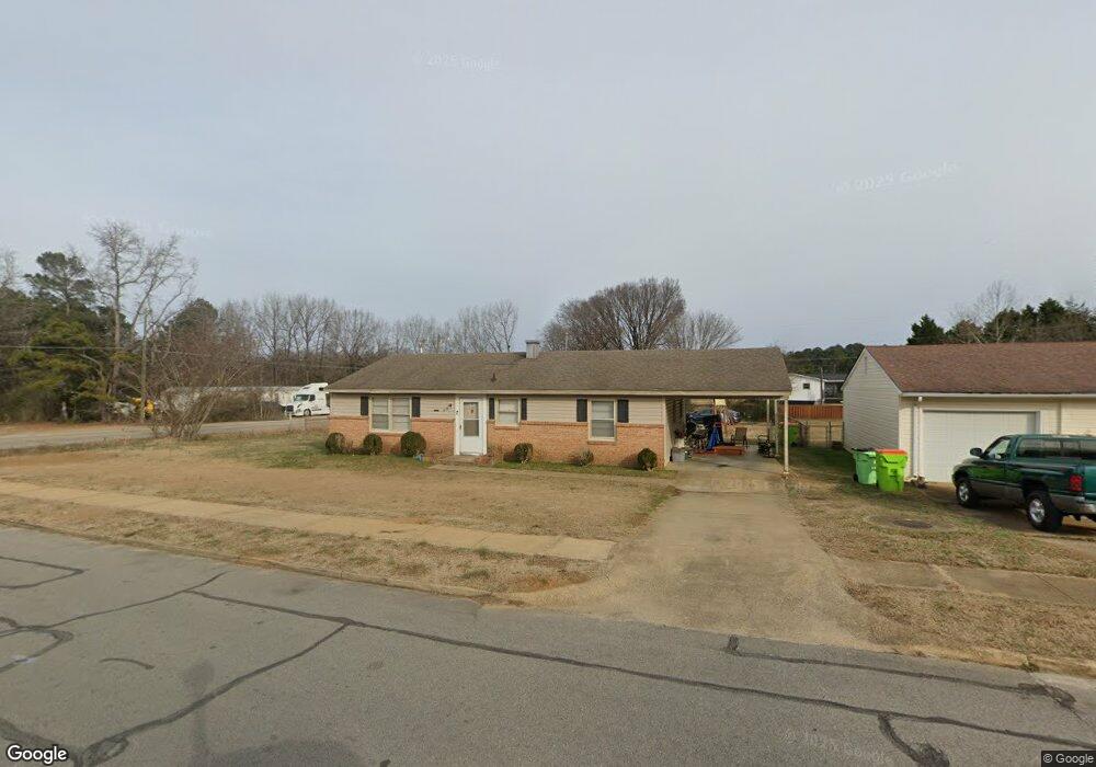
21 Radar Circle Rd Roanoke Rapids, NC 27870
Estimated Value: $54,000 - $161,000
3
Beds
1
Bath
1,200
Sq Ft
$102/Sq Ft
Est. Value
About This Home
This home is located at 21 Radar Circle Rd, Roanoke Rapids, NC 27870 and is currently estimated at $122,667, approximately $102 per square foot. 21 Radar Circle Rd is a home located in Halifax County with nearby schools including Everetts Elementary School, William R. Davie Middle School, and Northwest Halifax High School.
Ownership History
Date
Name
Owned For
Owner Type
Purchase Details
Closed on
Feb 21, 2024
Sold by
Radiant Real Estate Investments Llc
Bought by
Veyma Properties Llc
Current Estimated Value
Purchase Details
Closed on
May 30, 2006
Sold by
Citifinancial Services Inc
Bought by
Davis Michael T and Davis Debra W
Purchase Details
Closed on
Mar 14, 2006
Sold by
Hendricks Gloria
Bought by
Citifinancial Services Inc
Create a Home Valuation Report for This Property
The Home Valuation Report is an in-depth analysis detailing your home's value as well as a comparison with similar homes in the area
Home Values in the Area
Average Home Value in this Area
Purchase History
| Date | Buyer | Sale Price | Title Company |
|---|---|---|---|
| Veyma Properties Llc | $310,000 | None Listed On Document | |
| Veyma Properties Llc | $310,000 | None Listed On Document | |
| Davis Michael T | $38,000 | None Available | |
| Citifinancial Services Inc | $27,500 | None Available |
Source: Public Records
Tax History Compared to Growth
Tax History
| Year | Tax Paid | Tax Assessment Tax Assessment Total Assessment is a certain percentage of the fair market value that is determined by local assessors to be the total taxable value of land and additions on the property. | Land | Improvement |
|---|---|---|---|---|
| 2025 | $7 | $52,600 | $4,900 | $47,700 |
| 2024 | $7 | $52,600 | $4,900 | $47,700 |
| 2023 | $577 | $36,200 | $4,900 | $31,300 |
| 2022 | $591 | $36,200 | $4,900 | $31,300 |
| 2021 | $568 | $36,200 | $4,900 | $31,300 |
| 2020 | $568 | $36,200 | $4,900 | $31,300 |
| 2019 | $628 | $42,100 | $4,900 | $37,200 |
| 2018 | $615 | $42,100 | $4,900 | $37,200 |
| 2017 | $617 | $42,100 | $4,900 | $37,200 |
| 2016 | $583 | $42,100 | $4,900 | $37,200 |
| 2015 | $550 | $42,100 | $4,900 | $37,200 |
| 2014 | $551 | $45,910 | $6,310 | $39,600 |
Source: Public Records
Map
Nearby Homes
- 38 Buttercup Ln
- 0 Jennifers Ln Unit 140138
- 217 Easton St
- 37 Bald Eagle Dr
- 21 Bald Eagle Dr
- 25 Bald Eagle Dr
- 29 Bald Eagle Dr
- 31 Bald Eagle Dr
- 33 Bald Eagle Dr
- 35 Bald Eagle Dr
- 24 Bald Eagle Dr
- 26 Bald Eagle Dr
- 28 Bald Eagle Dr
- 32 Bald Eagle Dr
- 34 Bald Eagle Dr
- 36 Bald Eagle Dr
- 13 London Church Rd
- 154 Davie Wood Dr
- 0 Stonegate Dr Unit 140195
- 0 Stonegate Dr Unit 136251
- 25 Radar Circle Rd
- 51 Radar Circle Rd
- 233 Radar Circle Rd
- 26 Airbase Rd
- 42 Radar Circle Rd
- 55 Radar Circle Rd
- 229 Radar Circle Rd
- 496 Airbase Rd
- 432 Airbase Rd
- 496 Airbase Rd
- 46 Radar Circle Rd
- 476 Airbase Rd
- 192 Radar Circle Rd
- 79 Radar Circle Rd
- 205 Radar Circle Rd
- 78 Radar Circle Rd
- 50 Gardner Dr
- 186 Radar Circle Rd
- 201 Radar Circle Rd
- 83 Radar Circle Rd