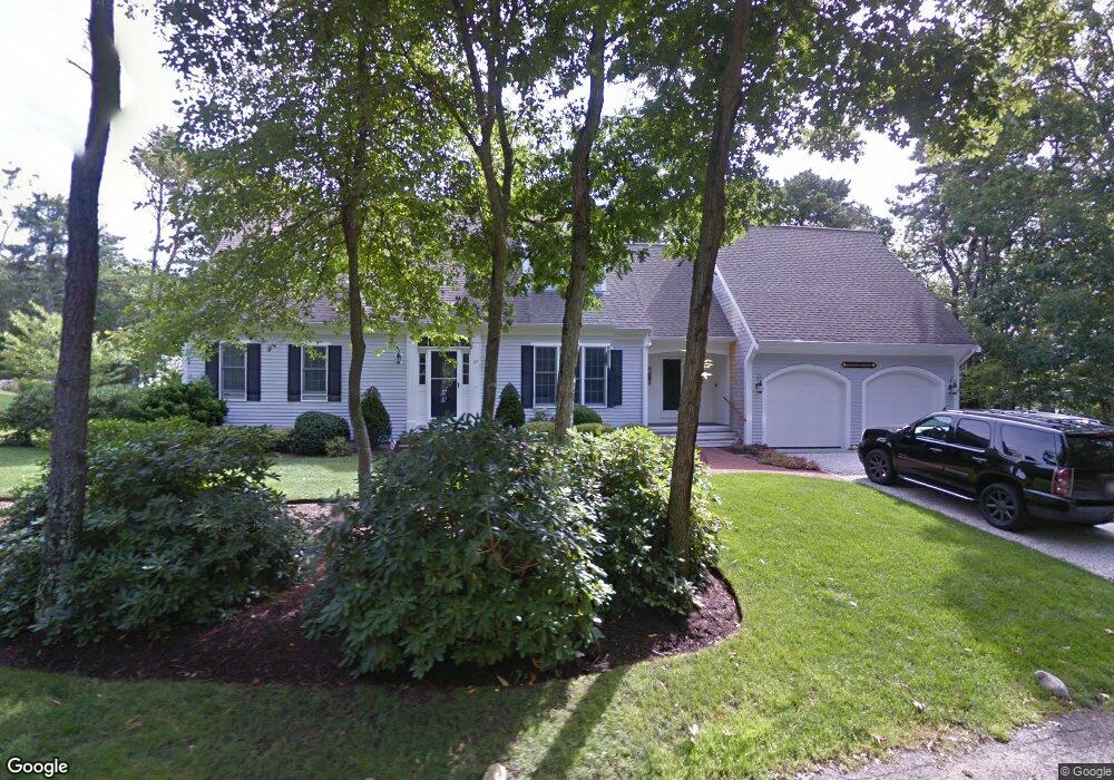
21 Skinequit Ln Harwich, MA 2645
Harwich Port NeighborhoodEstimated Value: $1,360,000 - $2,225,000
4
Beds
4
Baths
3,091
Sq Ft
$634/Sq Ft
Est. Value
About This Home
This home is located at 21 Skinequit Ln, Harwich, MA 2645 and is currently estimated at $1,959,942, approximately $634 per square foot. 21 Skinequit Ln is a home located in Barnstable County with nearby schools including Harwich Elementary School, Chatham Elementary School, and Monomoy Regional Middle School.
Ownership History
Date
Name
Owned For
Owner Type
Purchase Details
Closed on
Dec 6, 2023
Sold by
Jamey Power Irt and Power
Bought by
Kenrose Property Mgmt Llc
Current Estimated Value
Purchase Details
Closed on
Apr 16, 2009
Sold by
Power 3Rd James D
Bought by
Power 3Rd James David and Power Joan Heiler
Purchase Details
Closed on
Apr 16, 2004
Sold by
Borden Craig and Barber Peter J
Bought by
Power 3Rd James D
Purchase Details
Closed on
Mar 29, 2002
Sold by
Walker-Helwig Sarah
Bought by
Barber Peter J and Borden Craig
Create a Home Valuation Report for This Property
The Home Valuation Report is an in-depth analysis detailing your home's value as well as a comparison with similar homes in the area
Home Values in the Area
Average Home Value in this Area
Purchase History
| Date | Buyer | Sale Price | Title Company |
|---|---|---|---|
| Kenrose Property Mgmt Llc | -- | None Available | |
| Jamey Power Irt | -- | None Available | |
| Power 3Rd James David | -- | -- | |
| Survivors T T | -- | -- | |
| Power 3Rd James D | $925,000 | -- | |
| Barber Peter J | $275,000 | -- |
Source: Public Records
Tax History Compared to Growth
Tax History
| Year | Tax Paid | Tax Assessment Tax Assessment Total Assessment is a certain percentage of the fair market value that is determined by local assessors to be the total taxable value of land and additions on the property. | Land | Improvement |
|---|---|---|---|---|
| 2025 | $11,376 | $1,924,800 | $617,700 | $1,307,100 |
| 2024 | $10,204 | $1,692,200 | $582,700 | $1,109,500 |
| 2023 | $9,773 | $1,471,900 | $529,700 | $942,200 |
| 2022 | $9,619 | $1,186,100 | $460,700 | $725,400 |
| 2021 | $9,701 | $1,128,000 | $418,800 | $709,200 |
| 2020 | $9,648 | $1,105,200 | $408,300 | $696,900 |
| 2019 | $9,246 | $1,066,400 | $392,300 | $674,100 |
| 2018 | $8,792 | $970,000 | $356,700 | $613,300 |
| 2017 | $8,365 | $932,500 | $325,000 | $607,500 |
| 2016 | $8,216 | $905,800 | $325,000 | $580,800 |
| 2015 | $7,919 | $882,800 | $318,600 | $564,200 |
| 2014 | $7,571 | $863,300 | $309,100 | $554,200 |
Source: Public Records
Map
Nearby Homes
- 6 Skinequit Pond Rd
- 252 Chatham Rd
- 8 Old Wharf Rd
- 92 Julien Rd
- 19 Deer Run
- 55 Spinnaker Ln
- 45 Indian Trail
- 1011 Massachusetts 28 Unit C-6
- 1011 Route 28 Unit 6
- 34 Sea Mist Ln
- 6 Marthas Ln
- 32 Walton Rd
- 27 Saquatucket Bluffs Rd
- 29 Windward Walk
- 41 Woodland Rd
- 50 Hillside Rd
- 216 Forest Beach Rd
- 35 Sterling Rd
- 72 Forest Beach Rd
- 21 Skinequit Rd
- 27 Skinequit Rd
- 15 Skinequit Ln
- 9 Skinequit Rd
- 12 Skinequit Rd
- 33 Skinequit Rd
- 7 Skinequit Ln
- 19 Crowell Rd
- 10 Starboard Ln
- 5 Starboard Ln
- 15 Crowell Rd
- 6 Starboard Ln
- 10 Beach Hill Rd
- 20 Crowell Rd
- 3 Skinequit Ln
- 16 Crowell Rd
- 885 Route 28
- 6 Beach Hill Rd
- 119 Deep Hole Rd
- 2 Starboard Ln