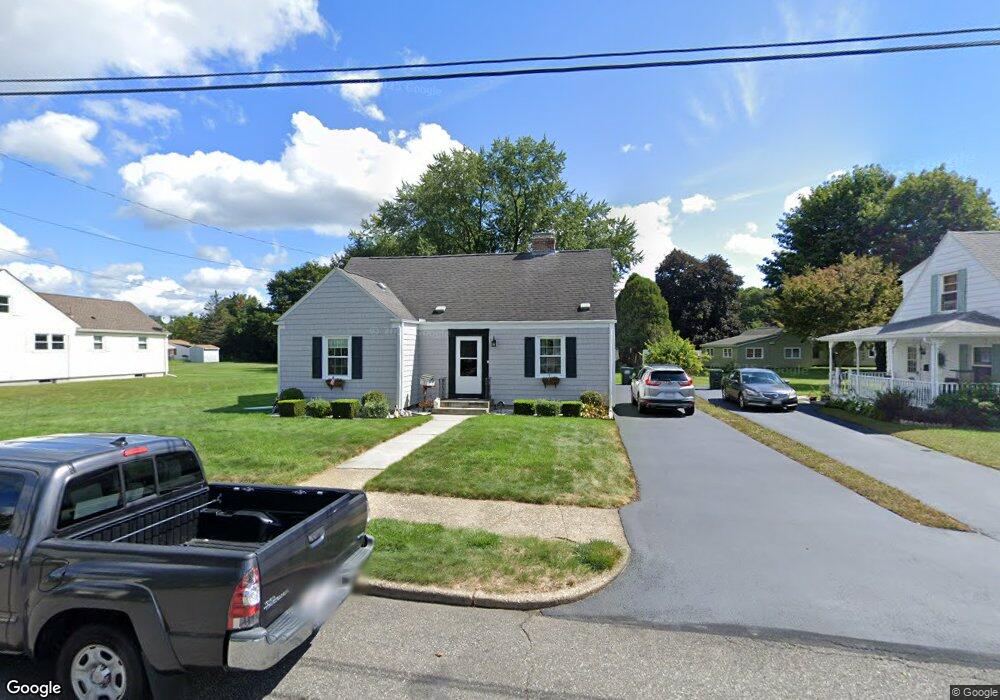
21 Strong St Palmer, MA 01069
Estimated Value: $284,000 - $364,000
4
Beds
1
Bath
1,569
Sq Ft
$210/Sq Ft
Est. Value
About This Home
This home is located at 21 Strong St, Palmer, MA 01069 and is currently estimated at $329,017, approximately $209 per square foot. 21 Strong St is a home located in Hampden County with nearby schools including Old Mill Pond Elementary School, Converse Middle School, and Palmer High School.
Ownership History
Date
Name
Owned For
Owner Type
Purchase Details
Closed on
May 7, 2020
Sold by
Hoy Thomas H and Hoy Kathryn L
Bought by
Hoy Justin T and Deshano Tachel S
Current Estimated Value
Purchase Details
Closed on
Apr 16, 1987
Sold by
Phaneuf James R
Bought by
Hoy Thomas H
Create a Home Valuation Report for This Property
The Home Valuation Report is an in-depth analysis detailing your home's value as well as a comparison with similar homes in the area
Home Values in the Area
Average Home Value in this Area
Purchase History
| Date | Buyer | Sale Price | Title Company |
|---|---|---|---|
| Hoy Justin T | -- | None Available | |
| Hoy Justin T | -- | None Available | |
| Hoy Thomas H | $105,000 | -- |
Source: Public Records
Mortgage History
| Date | Status | Borrower | Loan Amount |
|---|---|---|---|
| Previous Owner | Hoy Thomas H | $80,000 | |
| Previous Owner | Hoy Thomas H | $15,000 | |
| Previous Owner | Hoy Thomas H | $86,000 | |
| Previous Owner | Hoy Thomas H | $87,200 |
Source: Public Records
Tax History Compared to Growth
Tax History
| Year | Tax Paid | Tax Assessment Tax Assessment Total Assessment is a certain percentage of the fair market value that is determined by local assessors to be the total taxable value of land and additions on the property. | Land | Improvement |
|---|---|---|---|---|
| 2025 | $4,169 | $229,700 | $57,400 | $172,300 |
| 2024 | $3,896 | $208,700 | $52,300 | $156,400 |
| 2023 | $3,789 | $194,900 | $52,300 | $142,600 |
| 2022 | $3,608 | $168,600 | $45,900 | $122,700 |
| 2021 | $3,685 | $164,600 | $50,500 | $114,100 |
| 2020 | $3,056 | $158,300 | $50,500 | $107,800 |
| 2019 | $3,505 | $158,300 | $50,500 | $107,800 |
| 2018 | $3,533 | $153,800 | $49,100 | $104,700 |
| 2017 | $3,317 | $153,800 | $49,100 | $104,700 |
| 2016 | $3,178 | $149,400 | $47,700 | $101,700 |
| 2015 | $3,082 | $149,400 | $47,700 | $101,700 |
Source: Public Records
Map
Nearby Homes
- 72 Quaboag Valley Co Op St Unit 70
- 2034 Pleasant St
- 1018-1020 Maple St
- 11 Allen St
- 268 Palmer Rd Unit 59
- 268 Palmer Rd Unit 44
- 268 Palmer Rd Unit 27
- 268 Palmer Rd Unit 2
- 44 Converse St
- 160 Breckenridge St
- 1415 Park St
- 207 Breckenridge St
- Lot 8 Breckenridge St
- 0 Hovey Rd
- L 65-35-1 Pine Hill Dr
- 0 St Unit 73414881
- Lot 0 Thorndike and Lawrence St
- 62-91 Lawrence St
- Lots 39-42 Lawrence
- 0 Flynt St