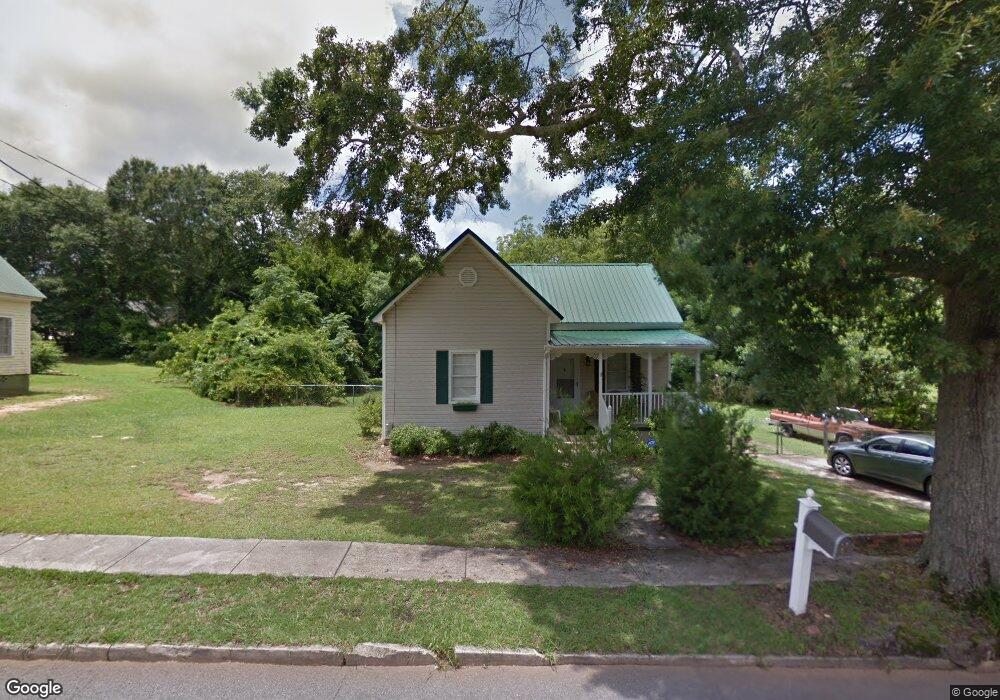
21 Thornton St Lagrange, GA 30241
Estimated Value: $100,000 - $116,979
2
Beds
1
Bath
1,360
Sq Ft
$79/Sq Ft
Est. Value
About This Home
This home is located at 21 Thornton St, Lagrange, GA 30241 and is currently estimated at $107,995, approximately $79 per square foot. 21 Thornton St is a home located in Troup County with nearby schools including Franklin Forest Elementary School, Hollis Hand Elementary School, and Ethel W. Kight Elementary School.
Ownership History
Date
Name
Owned For
Owner Type
Purchase Details
Closed on
Sep 28, 2010
Sold by
Wright William W
Bought by
Tucker Teresa
Current Estimated Value
Home Financials for this Owner
Home Financials are based on the most recent Mortgage that was taken out on this home.
Original Mortgage
$42,921
Outstanding Balance
$28,352
Interest Rate
4.37%
Mortgage Type
FHA
Estimated Equity
$79,643
Purchase Details
Closed on
Jun 2, 2010
Sold by
Secretary Of Housing
Bought by
Wright William W
Home Financials for this Owner
Home Financials are based on the most recent Mortgage that was taken out on this home.
Original Mortgage
$25,000
Interest Rate
5%
Mortgage Type
New Conventional
Purchase Details
Closed on
May 26, 2010
Sold by
Secretary Of Housing
Bought by
Wright William W
Home Financials for this Owner
Home Financials are based on the most recent Mortgage that was taken out on this home.
Original Mortgage
$25,000
Interest Rate
5%
Mortgage Type
New Conventional
Purchase Details
Closed on
Sep 1, 2009
Sold by
Hand Sheri C
Bought by
Wells Fargo Bank Na
Purchase Details
Closed on
Feb 20, 2003
Sold by
Bryan Ww Pete
Bought by
Hand Sheri C
Purchase Details
Closed on
Jun 15, 1990
Sold by
Sect Of V A
Bought by
Bryan Ww Pete
Purchase Details
Closed on
Sep 6, 1989
Sold by
Fleet Mortgage Corp
Bought by
Sect Of V A
Purchase Details
Closed on
Sep 5, 1989
Sold by
Andrew C Rahr
Bought by
Fleet Mortgage Corp
Purchase Details
Closed on
Sep 1, 1988
Sold by
Laurianne W Rahr
Bought by
Andrew C Rahr
Purchase Details
Closed on
Jan 1, 1988
Sold by
Laurianne Andrew and Laurianne Rahr
Bought by
Laurianne W Rahr
Purchase Details
Closed on
Aug 18, 1986
Sold by
Karr W T
Bought by
Laurianne Andrew and Laurianne Rahr
Purchase Details
Closed on
Aug 1, 1986
Bought by
Karr W T
Purchase Details
Closed on
Oct 1, 1985
Sold by
Nellie Willard and Nellie Karr
Purchase Details
Closed on
Jan 1, 1971
Sold by
Byrd
Bought by
Nellie Willard and Nellie Karr
Purchase Details
Closed on
Jan 1, 1970
Sold by
Byrd Heir Of Bonner
Bought by
Byrd
Create a Home Valuation Report for This Property
The Home Valuation Report is an in-depth analysis detailing your home's value as well as a comparison with similar homes in the area
Home Values in the Area
Average Home Value in this Area
Purchase History
| Date | Buyer | Sale Price | Title Company |
|---|---|---|---|
| Tucker Teresa | $43,500 | -- | |
| Tucker Teresa | $43,500 | -- | |
| Wright William W | $16,000 | -- | |
| Wright William W | $16,000 | -- | |
| Wells Fargo Bank Na | $58,946 | -- | |
| Wells Fargo Bank Na | $58,946 | -- | |
| Hand Sheri C | $56,000 | -- | |
| Bryan Ww Pete | -- | -- | |
| Sect Of V A | -- | -- | |
| Fleet Mortgage Corp | -- | -- | |
| Andrew C Rahr | -- | -- | |
| Laurianne W Rahr | -- | -- | |
| Laurianne Andrew | $30,000 | -- | |
| Karr W T | -- | -- | |
| -- | -- | -- | |
| Nellie Willard | $4,000 | -- | |
| Byrd | -- | -- |
Source: Public Records
Mortgage History
| Date | Status | Borrower | Loan Amount |
|---|---|---|---|
| Open | Tucker Teresa | $42,921 | |
| Previous Owner | Wright William W | $25,000 | |
| Previous Owner | Wells Fargo Bank Na | $25,000 |
Source: Public Records
Tax History Compared to Growth
Tax History
| Year | Tax Paid | Tax Assessment Tax Assessment Total Assessment is a certain percentage of the fair market value that is determined by local assessors to be the total taxable value of land and additions on the property. | Land | Improvement |
|---|---|---|---|---|
| 2024 | $887 | $34,520 | $6,720 | $27,800 |
| 2023 | $762 | $29,920 | $6,720 | $23,200 |
| 2022 | $716 | $27,640 | $6,720 | $20,920 |
| 2021 | $543 | $20,000 | $3,800 | $16,200 |
| 2020 | $543 | $20,000 | $3,800 | $16,200 |
| 2019 | $438 | $16,520 | $3,800 | $12,720 |
| 2018 | $439 | $16,528 | $3,808 | $12,720 |
| 2017 | $439 | $16,528 | $3,808 | $12,720 |
| 2016 | $427 | $16,156 | $3,808 | $12,348 |
| 2015 | $428 | $16,156 | $3,808 | $12,348 |
| 2014 | $409 | $15,506 | $3,808 | $11,698 |
| 2013 | -- | $15,999 | $3,808 | $12,191 |
Source: Public Records
Map
Nearby Homes
- 5 Curran Ave
- 15 Fulton St
- 130 Clara Jean Ct
- 0 N Barnard Ave
- 113 Lenox Cir
- Coleman Plan at Crossvine Village
- 0 Mill Creek Pkwy Unit PHASE 5 10313564
- Beckman Plan at Crossvine Village
- 0 Mill Creek Pkwy Unit PHASE 4 10313585
- Fairfield Plan at Crossvine Village
- Broadmoor Plan at Crossvine Village
- Dover Plan at Crossvine Village
- 906 Georgia Ave
- 305 Lenox Cir
- 227 River Meadow Dr Unit H14
- 231 River Meadow Dr
- 412 Sweetwood Ct Unit A36
- 902 Georgia Ave
- 105 Lenox Cir
- 101 Lenox Cir
- 19 Thornton St
- 0 Thornton St Unit 8461780
- 0 Thornton St Unit 8283320
- 0 Thornton St Unit 7149707
- 23 Thornton St
- 17 Thornton St
- 22 Thornton St
- 25 Thornton St
- 24 Barnard Ave
- 24 Thornton St
- 20 Thornton St
- 22 Barnard Ave
- 26 Barnard Ave
- 20 Barnard Ave
- 28 Barnard Ave
- 18 Thornton St
- 26 Thornton St
- 15 Thornton St
- 27 Thornton St
- 23 Barnard Ave