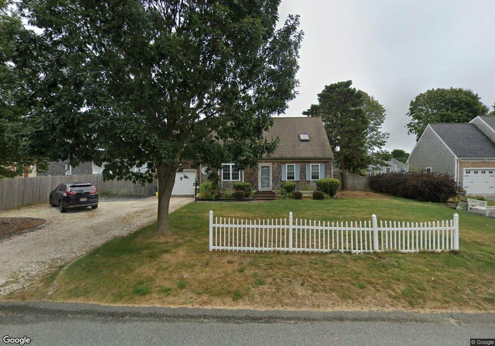
21 Timothy Bourne Cartway East Falmouth, MA 02536
Estimated Value: $717,107 - $884,000
3
Beds
3
Baths
1,800
Sq Ft
$453/Sq Ft
Est. Value
About This Home
This home is located at 21 Timothy Bourne Cartway, East Falmouth, MA 02536 and is currently estimated at $815,027, approximately $452 per square foot. 21 Timothy Bourne Cartway is a home located in Barnstable County with nearby schools including East Falmouth Elementary School, Morse Pond School, and Lawrence School.
Ownership History
Date
Name
Owned For
Owner Type
Purchase Details
Closed on
May 19, 2005
Sold by
Cranberry Hts Rt and Druley
Bought by
Chen He Se
Current Estimated Value
Home Financials for this Owner
Home Financials are based on the most recent Mortgage that was taken out on this home.
Original Mortgage
$318,000
Outstanding Balance
$166,977
Interest Rate
5.95%
Mortgage Type
Purchase Money Mortgage
Estimated Equity
$648,050
Create a Home Valuation Report for This Property
The Home Valuation Report is an in-depth analysis detailing your home's value as well as a comparison with similar homes in the area
Home Values in the Area
Average Home Value in this Area
Purchase History
| Date | Buyer | Sale Price | Title Company |
|---|---|---|---|
| Chen He Se | $425,000 | -- | |
| Chen He Se | $425,000 | -- |
Source: Public Records
Mortgage History
| Date | Status | Borrower | Loan Amount |
|---|---|---|---|
| Open | Chen He Se | $318,000 | |
| Closed | Chen He Se | $318,000 |
Source: Public Records
Tax History Compared to Growth
Tax History
| Year | Tax Paid | Tax Assessment Tax Assessment Total Assessment is a certain percentage of the fair market value that is determined by local assessors to be the total taxable value of land and additions on the property. | Land | Improvement |
|---|---|---|---|---|
| 2025 | $3,907 | $665,600 | $154,900 | $510,700 |
| 2024 | $3,803 | $605,600 | $140,200 | $465,400 |
| 2023 | $3,747 | $541,500 | $140,200 | $401,300 |
| 2022 | $3,293 | $409,100 | $88,200 | $320,900 |
| 2021 | $3,129 | $368,100 | $84,400 | $283,700 |
| 2020 | $3,096 | $360,400 | $76,700 | $283,700 |
| 2019 | $2,770 | $323,600 | $76,700 | $246,900 |
| 2018 | $2,712 | $315,300 | $76,700 | $238,600 |
| 2017 | $2,602 | $305,000 | $76,700 | $228,300 |
| 2016 | $2,553 | $305,000 | $76,700 | $228,300 |
| 2015 | $2,498 | $305,000 | $76,700 | $228,300 |
| 2014 | $2,500 | $306,800 | $80,600 | $226,200 |
Source: Public Records
Map
Nearby Homes
- 8 Dylans Way
- 28 Sheila Way
- 16 Annette Ave
- 27 Emerald Ln
- 0 Elsies Way Unit 73443603
- 0 Elsies Way Unit 22505181
- 36 Sadys Ln
- 14 Old Meeting House Rd
- 42 Hanson Cir
- 67 Vidal Ave
- 7 Yale Dr
- 11 Pershing Dr
- 25 Mill Farm Way Unit 25
- 25 Mill Farm Way
- 22 Mill Farm Way Unit 22
- 22 Mill Farm Way Unit 2
- 22 Corn Hill Rd
- 9 Ashley Dr
- 45 Green Pond Rd
- 25 Mill Pond Way
- 17 Timothy Bourne Cartway
- 25 Timothy Bourne Cartway
- 10 Rebecca Ann Ln
- 10 Rebecca Ann Ln
- 10 Rebecca Ann Ln Unit 3A, 5A
- 0 Rebecca Ann Ln Unit B 2038260
- 0 Rebecca Ann Ln Unit 11
- 11 Timothy Bourne Cartway
- 11 Timothy Bourne Cartway
- 16 Timothy Bourne Cartway
- 33 Timothy Bourne Cartway
- 1 Timothy Bourne Cartway
- 26 Timothy Bourne Cartway
- 150 Timothy Bourne Cartway
- 150 Timothy Bourne Cartway Unit 5
- 34 Timothy Bourne Cartway
- 15 Rebecca Ann Ln Unit A
- 15 Rebecca Ann Ln Unit 15 A
- 15 Rebecca Ann Ln
- 15 Rebecca Ann Ln Unit B