
Seller's Agent in 2025
Chuck Tuttle
William Raveis Real Estate & Home Services
(508) 367-8800
32 in this area
128 Total Sales

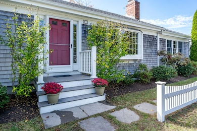
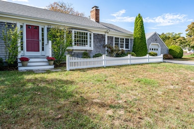
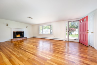

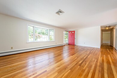
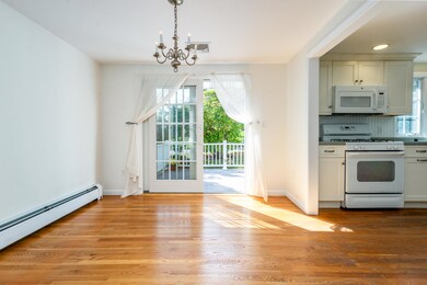
Sparkling Centerville! Lovely home with easy living floor plan, nicely updated, very well-maintained. The Cathedral Ceiling Family Room with Hardwood Floors is a wonderful introduction, step up to the Kitchen with Breakfast Nook and gas range, and into the lovely Dining Room, with glass doors to the Trex Deck overlooking the lovely backyard, complete with electric awning. Living Room with Bay Window and wood-burning Fireplace, perfect for Cape Cod winters. Two ample bedrooms, one with a private full bathroom en suite. Central Air Conditioning in 2004, hot water heater in 2014, natural gas emergency generator 2019, new boiler and roof in 2021. Oversize 1-Bay Garage, and with covered breezeway to the main house. Wonderful neighborhood right in Centerville Village, walk to parades, General Store, Four Seas Ice Cream, less than a mile to Craigville Beach. Just right!
Last Agent to Sell the Property
William Raveis Real Estate & Home Services License #9083063 Listed on: 10/08/2025
Last Buyer's Agent
Buyer Unrepresented
cci.UnrepBuyer
| Date | Type | Sale Price | Title Company |
|---|---|---|---|
| Quit Claim Deed | $655,000 | -- | |
| Quit Claim Deed | -- | -- | |
| Deed | $342,500 | -- |
| Date | Status | Loan Amount | Loan Type |
|---|---|---|---|
| Previous Owner | $240,000 | Purchase Money Mortgage |
| Date | Event | Price | List to Sale | Price per Sq Ft |
|---|---|---|---|---|
| 11/21/2025 11/21/25 | Sold | $655,000 | -3.0% | $400 / Sq Ft |
| 10/24/2025 10/24/25 | Pending | -- | -- | -- |
| 10/08/2025 10/08/25 | For Sale | $675,000 | -- | $412 / Sq Ft |
| Year | Tax Paid | Tax Assessment Tax Assessment Total Assessment is a certain percentage of the fair market value that is determined by local assessors to be the total taxable value of land and additions on the property. | Land | Improvement |
|---|---|---|---|---|
| 2025 | $4,623 | $571,400 | $152,200 | $419,200 |
| 2024 | $4,393 | $562,500 | $152,200 | $410,300 |
| 2023 | $4,103 | $492,000 | $138,400 | $353,600 |
| 2022 | $3,973 | $412,100 | $102,500 | $309,600 |
| 2021 | $3,753 | $357,800 | $102,500 | $255,300 |
| 2020 | $3,626 | $330,800 | $102,500 | $228,300 |
| 2019 | $3,416 | $302,800 | $102,500 | $200,300 |
| 2018 | $3,106 | $276,800 | $107,900 | $168,900 |
| 2017 | $2,889 | $268,500 | $107,900 | $160,600 |
| 2016 | $2,935 | $269,300 | $108,700 | $160,600 |
| 2015 | $2,864 | $264,000 | $105,400 | $158,600 |
Seller's Agent in 2025
Chuck Tuttle
William Raveis Real Estate & Home Services
(508) 367-8800
32 in this area
128 Total Sales
B
Buyer's Agent in 2025
Buyer Unrepresented
cci.UnrepBuyer
Source: Cape Cod & Islands Association of REALTORS®
MLS Number: 22505076
APN: CENT-000208-000000-000053
Disclaimer: Certain information contained herein is derived from information provided by parties other than Homes.com. All information provided is deemed reliable, but is not guaranteed to be accurate and should be independently verified.
![]() All data relating to real estate for sale on this page comes from the Broker Reciprocity (BR) of the Cape Cod & Islands Multiple Listing Service, Inc. Detailed information about real estate listings held by brokerage firms other than CC&I Assoc. of REALTORS®, Inc. includes the name of the listing company. Neither the listing company nor CC&I Assoc. of REALTORS®, Inc. shall be responsible for any typographical errors, misinformation, misprints and shall be held totally harmless. The Broker providing this data believes it to be correct, but advises interested parties to confirm any item before relying on it in a purchase decision. All properties are subject to prior sale, changes, or withdrawal. Copyright 2026 © Cape Cod & Islands Multiple Listing Service, Inc. All rights reserved.
All data relating to real estate for sale on this page comes from the Broker Reciprocity (BR) of the Cape Cod & Islands Multiple Listing Service, Inc. Detailed information about real estate listings held by brokerage firms other than CC&I Assoc. of REALTORS®, Inc. includes the name of the listing company. Neither the listing company nor CC&I Assoc. of REALTORS®, Inc. shall be responsible for any typographical errors, misinformation, misprints and shall be held totally harmless. The Broker providing this data believes it to be correct, but advises interested parties to confirm any item before relying on it in a purchase decision. All properties are subject to prior sale, changes, or withdrawal. Copyright 2026 © Cape Cod & Islands Multiple Listing Service, Inc. All rights reserved.
Ask me questions while you tour the home.