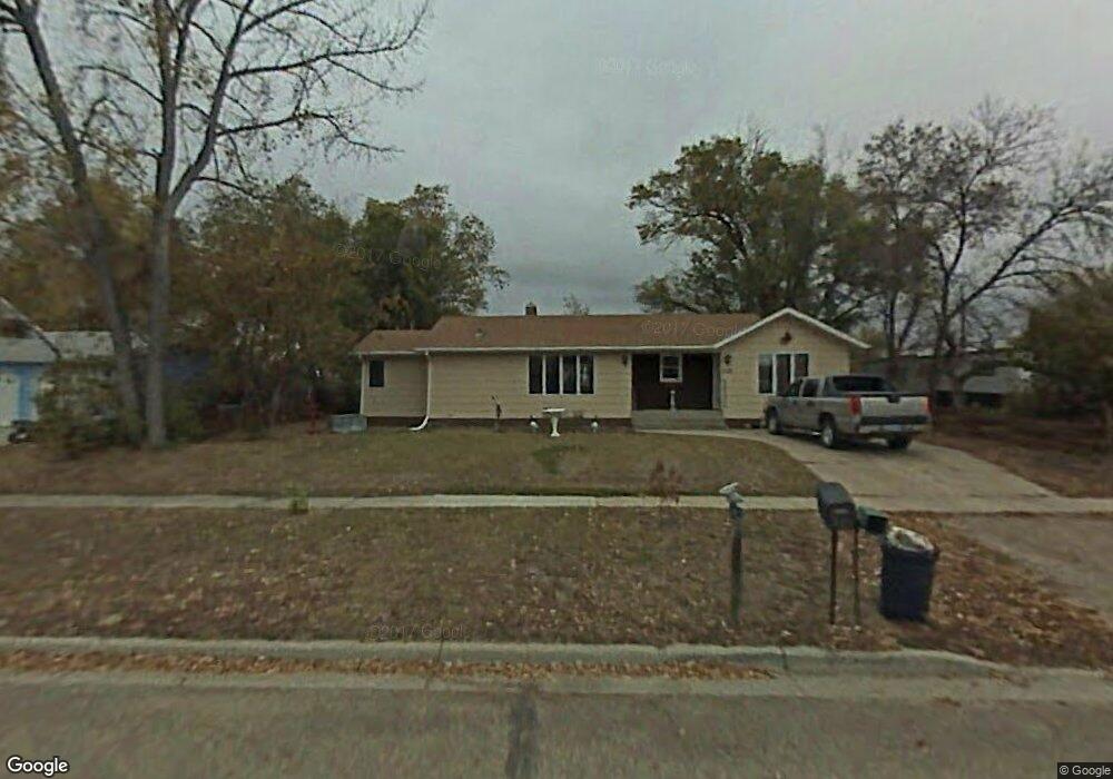
210 5th St N New Town, ND 58763
Estimated Value: $218,000 - $294,705
Studio
--
Bath
--
Sq Ft
11,761
Sq Ft Lot
About This Home
This home is located at 210 5th St N, New Town, ND 58763 and is currently estimated at $256,353. 210 5th St N is a home with nearby schools including Edwin Loe Elementary School, New Town Middle School, and New Town High School.
Ownership History
Date
Name
Owned For
Owner Type
Purchase Details
Closed on
Jan 26, 2021
Sold by
Najam and Noemi
Bought by
Flores Eladin G and Munoz Brittnie E
Current Estimated Value
Home Financials for this Owner
Home Financials are based on the most recent Mortgage that was taken out on this home.
Original Mortgage
$314,204
Interest Rate
3.45%
Mortgage Type
New Conventional
Purchase Details
Closed on
Jun 25, 2019
Sold by
Satermo Rita A
Bought by
Najam Shoaib and Najam Noemi Tena
Home Financials for this Owner
Home Financials are based on the most recent Mortgage that was taken out on this home.
Original Mortgage
$103,477
Interest Rate
4%
Mortgage Type
Construction
Create a Home Valuation Report for This Property
The Home Valuation Report is an in-depth analysis detailing your home's value as well as a comparison with similar homes in the area
Purchase History
| Date | Buyer | Sale Price | Title Company |
|---|---|---|---|
| Flores Eladin G | $320,000 | North Dakota Guaranty & Title | |
| Najam Shoaib | $129,346 | North Dakota Guaranty & Title |
Source: Public Records
Mortgage History
| Date | Status | Borrower | Loan Amount |
|---|---|---|---|
| Previous Owner | Flores Eladin G | $314,204 | |
| Previous Owner | Najam Shoaib | $103,477 |
Source: Public Records
Tax History
| Year | Tax Paid | Tax Assessment Tax Assessment Total Assessment is a certain percentage of the fair market value that is determined by local assessors to be the total taxable value of land and additions on the property. | Land | Improvement |
|---|---|---|---|---|
| 2024 | $1,308 | $123,050 | $19,200 | $103,850 |
| 2023 | $1,337 | $123,350 | $19,200 | $104,150 |
| 2022 | $1,184 | $112,300 | $19,200 | $93,100 |
| 2021 | $1,351 | $111,250 | $19,200 | $92,050 |
| 2020 | $1,563 | $119,850 | $19,200 | $100,650 |
| 2019 | $1,113 | $78,850 | $19,350 | $59,500 |
| 2018 | $1,213 | $78,850 | $19,350 | $59,500 |
| 2017 | $990 | $58,550 | $17,700 | $40,850 |
| 2016 | $916 | $62,600 | $17,700 | $44,900 |
| 2015 | $779 | $50,800 | $5,900 | $44,900 |
| 2014 | $925 | $47,850 | $2,950 | $44,900 |
| 2013 | $925 | $0 | $0 | $0 |
Source: Public Records
Map
Nearby Homes
- 706 1st St N
- 9155 41st St NW
- 8571 39th St NW
- TBD Lot 11
- TBD Lot 8
- TBD Lot 10
- TBD Lot 9
- 114 1st Ave NE
- 0 61st St & Hwy 8 S Unit 230938
- Phase 4 John Rian Subdivision
- 10641 23rd St NW
- 311 N Main St
- 440 1st St NW Unit Stanley
- 221 Adeline Dr
- 359 Adeline Dr
- 363 Adeline Dr
- TBD Robyn's Cir
- Phase 5 John Rian Subdivision
- 0 Opportunity Dr Unit 250496
Your Personal Tour Guide
Ask me questions while you tour the home.