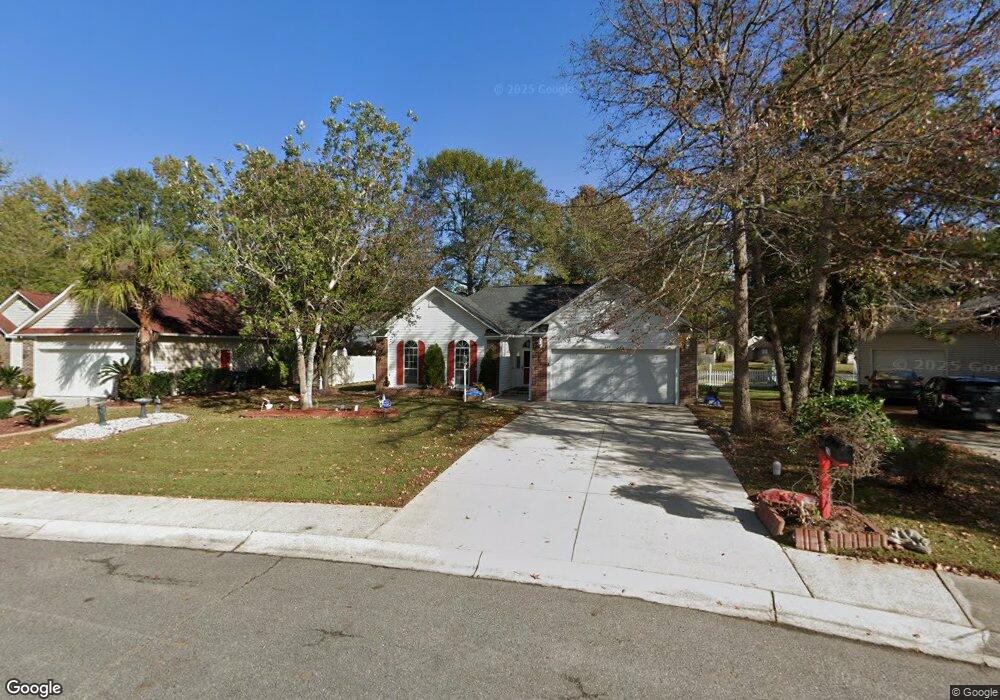
210 Ashton Cir Myrtle Beach, SC 29588
Estimated Value: $283,588 - $308,000
3
Beds
2
Baths
1,498
Sq Ft
$198/Sq Ft
Est. Value
About This Home
This home is located at 210 Ashton Cir, Myrtle Beach, SC 29588 and is currently estimated at $296,147, approximately $197 per square foot. 210 Ashton Cir is a home located in Horry County with nearby schools including Lakewood Elementary, Socastee Middle, and Socastee High School.
Ownership History
Date
Name
Owned For
Owner Type
Purchase Details
Closed on
Oct 30, 2000
Sold by
Ussery Stephen E and Ussery Tara R
Bought by
Esper Gregory C and Esper Sandra A
Current Estimated Value
Home Financials for this Owner
Home Financials are based on the most recent Mortgage that was taken out on this home.
Original Mortgage
$100,000
Outstanding Balance
$36,979
Interest Rate
7.93%
Mortgage Type
Purchase Money Mortgage
Estimated Equity
$259,168
Purchase Details
Closed on
Dec 17, 1998
Sold by
Lindenwald Doris Sharpe
Bought by
Ussery Stephen E and Ussery Tara R
Home Financials for this Owner
Home Financials are based on the most recent Mortgage that was taken out on this home.
Original Mortgage
$226,000
Interest Rate
6.87%
Mortgage Type
Purchase Money Mortgage
Create a Home Valuation Report for This Property
The Home Valuation Report is an in-depth analysis detailing your home's value as well as a comparison with similar homes in the area
Home Values in the Area
Average Home Value in this Area
Purchase History
| Date | Buyer | Sale Price | Title Company |
|---|---|---|---|
| Esper Gregory C | $133,000 | -- | |
| Ussery Stephen E | $129,900 | -- |
Source: Public Records
Mortgage History
| Date | Status | Borrower | Loan Amount |
|---|---|---|---|
| Open | Esper Gregory C | $100,000 | |
| Previous Owner | Ussery Stephen E | $226,000 |
Source: Public Records
Tax History Compared to Growth
Tax History
| Year | Tax Paid | Tax Assessment Tax Assessment Total Assessment is a certain percentage of the fair market value that is determined by local assessors to be the total taxable value of land and additions on the property. | Land | Improvement |
|---|---|---|---|---|
| 2024 | $757 | $10,631 | $3,910 | $6,721 |
| 2023 | $757 | $6,311 | $1,409 | $4,902 |
| 2021 | $686 | $6,349 | $1,409 | $4,940 |
| 2020 | $593 | $6,349 | $1,409 | $4,940 |
| 2019 | $593 | $6,349 | $1,409 | $4,940 |
| 2018 | $536 | $5,488 | $1,268 | $4,220 |
| 2017 | $521 | $5,488 | $1,268 | $4,220 |
| 2016 | -- | $5,488 | $1,268 | $4,220 |
| 2015 | $531 | $5,488 | $1,268 | $4,220 |
| 2014 | $956 | $5,488 | $1,268 | $4,220 |
Source: Public Records
Map
Nearby Homes
- 130 Ashton Cir
- 104 Willow Ridge Rd
- 333 Ashwood Ln Unit MB
- 105 Willow Ridge Rd
- 6357 Highway 707
- 280 Hidden Woods Dr
- 6189 Highway 707 Unit Signalized intersect
- 279 Leste Rd
- 449 Levanto Rd
- 237 Delano Way
- 201 Delano Way
- 347 Leste Rd
- 118 Sly Fox Trail
- 3910 Stillwood Dr
- 3990 Lochview Dr
- 411 Moss Pond Rd
- 7420 Springside Dr
- 304 Silver Fox Trail
- 4096 Grousewood Dr
- 812 Hayes Point Cir
- 208 Ashton Cir
- 212 Ashton Cir Unit MB
- 414 Ashwood Ln
- 206 Ashton Cir
- 205 Ashton Cir
- 416 Ashwood Ln Unit MB
- 408 Ashwood Ln
- 410 Ashwood Ln Unit Hidden Woods
- 410 Ashwood Ln
- 204 Ashton Cir
- 211 Berkshire Dr Unit Hidden Woods
- 211 Berkshire Dr
- 209 Berkshire Dr
- 412 Ashwood Ln Unit Hidden Woods
- 412 Ashwood Ln Unit MB
- 213 Berkshire Dr
- 203 Ashton Cir
- 207 Berkshire Dr
- 406 Ashwood Ln Unit MB
- 406 Ashwood Ln