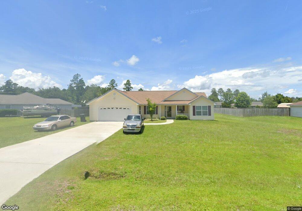
210 Brooksdale Rd Brunswick, GA 31523
Estimated Value: $255,163 - $300,000
3
Beds
2
Baths
1,432
Sq Ft
$194/Sq Ft
Est. Value
About This Home
This home is located at 210 Brooksdale Rd, Brunswick, GA 31523 and is currently estimated at $278,291, approximately $194 per square foot. 210 Brooksdale Rd is a home located in Glynn County with nearby schools including Satilla Marsh Elementary School, Risley Middle School, and Glynn Academy.
Ownership History
Date
Name
Owned For
Owner Type
Purchase Details
Closed on
Mar 1, 2007
Sold by
Invey Johns Construction I
Bought by
Jones Sherrie
Current Estimated Value
Home Financials for this Owner
Home Financials are based on the most recent Mortgage that was taken out on this home.
Original Mortgage
$136,959
Outstanding Balance
$82,669
Interest Rate
6.3%
Mortgage Type
New Conventional
Estimated Equity
$195,622
Purchase Details
Closed on
Nov 30, 2006
Sold by
Johns Land Co Inc
Bought by
Ivey Johns Construction Inc
Create a Home Valuation Report for This Property
The Home Valuation Report is an in-depth analysis detailing your home's value as well as a comparison with similar homes in the area
Home Values in the Area
Average Home Value in this Area
Purchase History
| Date | Buyer | Sale Price | Title Company |
|---|---|---|---|
| Jones Sherrie | $141,195 | -- | |
| Ivey Johns Construction Inc | $50,000 | -- |
Source: Public Records
Mortgage History
| Date | Status | Borrower | Loan Amount |
|---|---|---|---|
| Open | Jones Sherrie | $136,959 |
Source: Public Records
Tax History Compared to Growth
Tax History
| Year | Tax Paid | Tax Assessment Tax Assessment Total Assessment is a certain percentage of the fair market value that is determined by local assessors to be the total taxable value of land and additions on the property. | Land | Improvement |
|---|---|---|---|---|
| 2025 | $2,112 | $84,200 | $9,360 | $74,840 |
| 2024 | $2,050 | $81,760 | $5,000 | $76,760 |
| 2023 | $1,029 | $81,760 | $5,000 | $76,760 |
| 2022 | $1,438 | $64,960 | $5,000 | $59,960 |
| 2021 | $1,424 | $55,240 | $3,400 | $51,840 |
| 2020 | $1,312 | $50,520 | $3,400 | $47,120 |
| 2019 | $1,312 | $50,520 | $3,400 | $47,120 |
| 2018 | $1,312 | $50,520 | $3,400 | $47,120 |
| 2017 | $1,189 | $45,800 | $3,400 | $42,400 |
| 2016 | $1,091 | $44,880 | $7,200 | $37,680 |
| 2015 | $1,096 | $44,880 | $7,200 | $37,680 |
| 2014 | $1,096 | $44,880 | $7,200 | $37,680 |
Source: Public Records
Map
Nearby Homes
- 132 Mister Rd
- 546 Emanuel Church Rd
- 117 Rachel Way
- 110 Rachel Way
- 94 Silver Bluff Dr
- 40 Jada Ln
- 18 Ace Cir
- 113 Haven Ct
- 993 Myers Hill Rd
- 269 Oyster Rd
- 179 Oyster Rd
- 145 Oyster Rd
- 224 Oyster Cir
- 36 Carlee Ln
- 261 & 245 Fish Hall Rd
- 109 Cains Trace
- 126 Cains Trace
- 190 Lakes Dr
- 136 Michigan Way
- 127 Huron Loop
- 222 Brooksdale Rd
- 200 Brooksdale Rd
- 228 Brooksdale Rd
- 192 Brooksdale Rd
- 234 Brooksdale Rd
- 209 Brooksdale Rd
- 203 Brooksdale Rd
- 215 Brooksdale Rd Unit Phs II
- 215 Brooksdale Rd
- 184 Brooksdale Rd
- 221 Brooksdale Rd
- 193 Brooksdale Rd
- 227 Brooksdale Rd
- 138 Ratcliffe Rd
- 44 Angelwood Ct
- 144 Ratcliff Rd
- 138 Ratcliff Rd
- 152 Ratcliff Rd
- 45 Angelwood Ct
- 233 Brooksdale Rd