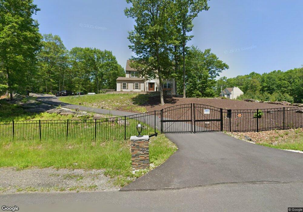
210 Buck Rd East Stroudsburg, PA 18302
Estimated Value: $428,000 - $493,000
4
Beds
3
Baths
2,105
Sq Ft
$212/Sq Ft
Est. Value
About This Home
This home is located at 210 Buck Rd, East Stroudsburg, PA 18302 and is currently estimated at $446,525, approximately $212 per square foot. 210 Buck Rd is a home with nearby schools including East Stroudsburg Elementary School, J.T. Lambert Intermediate School, and East Stroudsburg Senior High School South.
Ownership History
Date
Name
Owned For
Owner Type
Purchase Details
Closed on
Jul 15, 2013
Sold by
Lts Homes Inc
Bought by
Miles Ronnie and Swanson Nichelle
Current Estimated Value
Home Financials for this Owner
Home Financials are based on the most recent Mortgage that was taken out on this home.
Original Mortgage
$255,192
Outstanding Balance
$194,612
Interest Rate
5.12%
Mortgage Type
FHA
Estimated Equity
$251,913
Create a Home Valuation Report for This Property
The Home Valuation Report is an in-depth analysis detailing your home's value as well as a comparison with similar homes in the area
Home Values in the Area
Average Home Value in this Area
Purchase History
| Date | Buyer | Sale Price | Title Company |
|---|---|---|---|
| Miles Ronnie | $259,900 | None Available |
Source: Public Records
Mortgage History
| Date | Status | Borrower | Loan Amount |
|---|---|---|---|
| Open | Miles Ronnie | $255,192 |
Source: Public Records
Tax History Compared to Growth
Tax History
| Year | Tax Paid | Tax Assessment Tax Assessment Total Assessment is a certain percentage of the fair market value that is determined by local assessors to be the total taxable value of land and additions on the property. | Land | Improvement |
|---|---|---|---|---|
| 2025 | $1,666 | $260,710 | $45,270 | $215,440 |
| 2024 | $1,274 | $260,710 | $45,270 | $215,440 |
| 2023 | $9,043 | $260,710 | $45,270 | $215,440 |
| 2022 | $9,168 | $260,710 | $45,270 | $215,440 |
| 2021 | $9,025 | $260,710 | $45,270 | $215,440 |
| 2020 | $8,725 | $260,710 | $45,270 | $215,440 |
| 2019 | $8,258 | $40,640 | $7,000 | $33,640 |
| 2018 | $8,258 | $40,640 | $7,000 | $33,640 |
| 2017 | $8,258 | $40,640 | $7,000 | $33,640 |
| 2016 | $7,832 | $40,640 | $7,000 | $33,640 |
| 2015 | -- | $40,640 | $7,000 | $33,640 |
| 2014 | -- | $40,640 | $7,000 | $33,640 |
Source: Public Records
Map
Nearby Homes
- 0 Deer Path
- 21 Deer Path
- 84 Lenape Dr
- Lot 31 & 32 Lenape Dr
- Lot18 Lenape Dr
- Lot 36 Lenape Dr
- 237 Footprint Rd
- Lot 17 Footprint Rd
- 28 Lenape Dr
- 430 Indian Way
- 0 Lenape Dr Unit Lot 31 & 32 763518
- 529 Highland Dr
- 0 Way
- 0 Lace Dr 24 Dr
- 53 Barren Rd
- 0 Green Meadow Dr
- Lot 24 Green Meadow Dr
- 1136 Sierra Trail
- 30 Ledgewood Ct
- 630 Wooddale Rd
- 206 Buck Rd
- 302 Lee's Run Cir
- 1063 Bear Swamp Rd
- 302 Lees Run Cir
- 301 Lees Run Cir
- 209 Buck Rd
- 1067 Bear Swamp Rd
- 213 Buck Rd
- 1039 Bear Swamp Rd
- 221 Buck Rd
- 202 Buck Rd
- 305 Lee's Run Cir
- 217 Buck Rd
- 314 Lees Run Cir
- 0 Lee's Run Cir
- Lot 140 Lee's Run Cir
- Lot 134 Lee's Run Cir
- 138 Lee's Run Cir
- 205 Buck Rd
- 306 Lees Run Cir