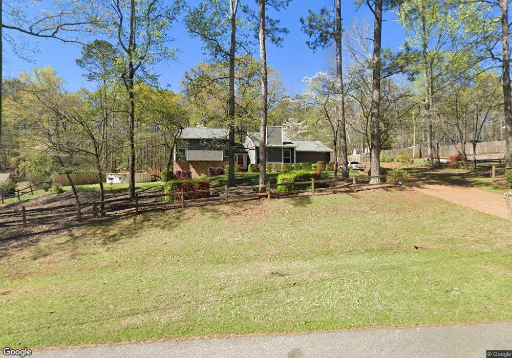
210 Cumberland Dr Lagrange, GA 30240
Estimated Value: $234,000 - $254,000
3
Beds
3
Baths
1,494
Sq Ft
$166/Sq Ft
Est. Value
About This Home
This home is located at 210 Cumberland Dr, Lagrange, GA 30240 and is currently estimated at $248,582, approximately $166 per square foot. 210 Cumberland Dr is a home located in Troup County with nearby schools including Long Cane Elementary School, Berta Weathersbee Elementary School, and Whitesville Road Elementary School.
Ownership History
Date
Name
Owned For
Owner Type
Purchase Details
Closed on
Feb 16, 2001
Sold by
Breemes Paul E and Breemes Meryl A
Bought by
Joe P Howell
Current Estimated Value
Purchase Details
Closed on
Jun 19, 1980
Sold by
Tom W Mclaughlin
Bought by
Breemes Paul E and Breemes Meryl A
Purchase Details
Closed on
Oct 19, 1978
Sold by
Joan D Moore
Bought by
Tom W Mclaughlin
Purchase Details
Closed on
Feb 2, 1978
Bought by
Joan D Moore
Purchase Details
Closed on
Jun 21, 1977
Create a Home Valuation Report for This Property
The Home Valuation Report is an in-depth analysis detailing your home's value as well as a comparison with similar homes in the area
Home Values in the Area
Average Home Value in this Area
Purchase History
| Date | Buyer | Sale Price | Title Company |
|---|---|---|---|
| Joe P Howell | $107,000 | -- | |
| Breemes Paul E | $63,000 | -- | |
| Tom W Mclaughlin | $53,000 | -- | |
| Joan D Moore | -- | -- | |
| -- | -- | -- |
Source: Public Records
Tax History Compared to Growth
Tax History
| Year | Tax Paid | Tax Assessment Tax Assessment Total Assessment is a certain percentage of the fair market value that is determined by local assessors to be the total taxable value of land and additions on the property. | Land | Improvement |
|---|---|---|---|---|
| 2024 | $2,112 | $79,440 | $14,000 | $65,440 |
| 2023 | $2,005 | $75,520 | $10,000 | $65,520 |
| 2022 | $1,916 | $70,640 | $8,000 | $62,640 |
| 2021 | $1,732 | $59,400 | $8,000 | $51,400 |
| 2020 | $1,732 | $59,400 | $8,000 | $51,400 |
| 2019 | $1,576 | $54,240 | $6,000 | $48,240 |
| 2018 | $1,583 | $54,480 | $6,240 | $48,240 |
| 2017 | $1,446 | $49,920 | $6,240 | $43,680 |
| 2016 | $1,425 | $49,247 | $6,240 | $43,007 |
| 2015 | $1,471 | $50,676 | $6,240 | $44,436 |
| 2014 | $1,474 | $50,676 | $6,240 | $44,436 |
| 2013 | -- | $50,676 | $6,240 | $44,436 |
Source: Public Records
Map
Nearby Homes
- 474 Newton Rd
- 101 Ivy Springs Dr
- 40 River Point Dr
- 119 Plymouth Dr
- 102 Franklin Place
- 108 Hidden Springs Dr
- 141 Plymouth Dr
- 1565 Glass Bridge Rd
- 106 Landings Way
- 102 Landings Way
- 201 Lakeview Ct
- 109 Riverbluff Dr
- 101 Riverbluff Dr
- 100 Huntcliff Ct
- 135 Planters Ridge Dr
- 102 Foxdale Dr
- 105 Hawthorne Cir
- 110 Hawthorne Cir
- 103 Hawthorne Cir
- 205 Linda Ln
- 208 Cumberland Dr
- 212 Cumberland Dr
- 211 Cumberland Dr
- 214 Cumberland Dr
- 206 Cumberland Dr
- 209 Cumberland Dr
- 216 Cumberland Dr
- 207 Cumberland Dr
- 204 Cumberland Dr
- 116 Timber Ridge Dr
- 218 Cumberland Dr
- 114 Timber Ridge Dr
- 205 Cumberland Dr
- 112 Timber Ridge Dr
- 202 Cumberland Dr
- 220 Cumberland Dr Unit 11
- 220 Cumberland Dr
- 519 Newton Rd
- 539 Newton Rd
- 203 Cumberland Dr