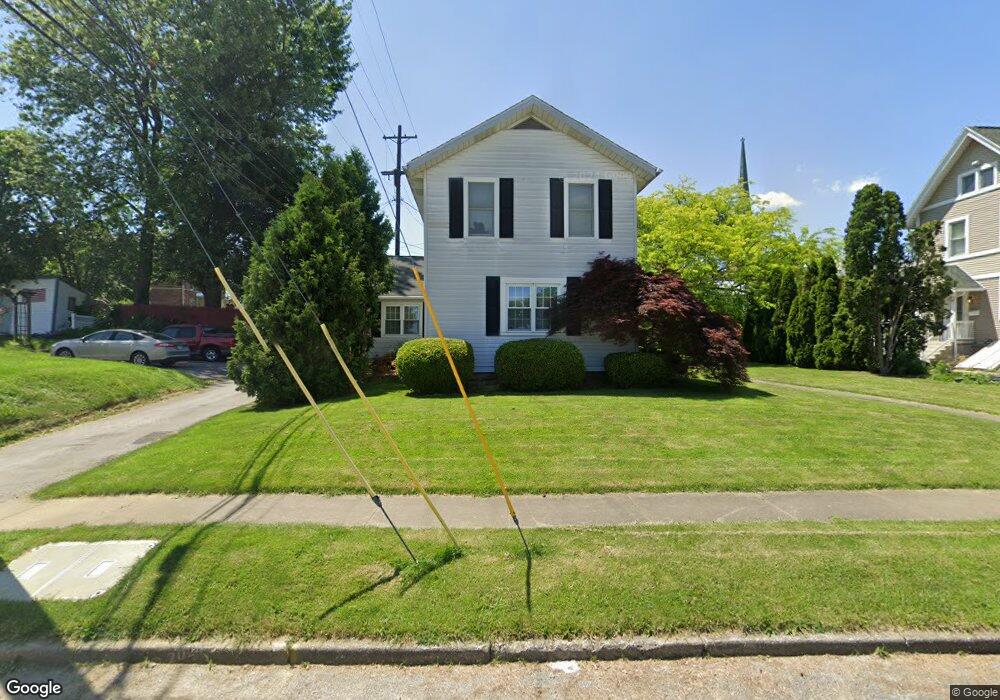
210 High St Fremont, OH 43420
Estimated Value: $132,885 - $165,000
2
Beds
2
Baths
1,512
Sq Ft
$98/Sq Ft
Est. Value
About This Home
This home is located at 210 High St, Fremont, OH 43420 and is currently estimated at $148,471, approximately $98 per square foot. 210 High St is a home located in Sandusky County with nearby schools including Fremont Ross High School, St. Joseph School, and Bishop Hoffman Catholic School - This is St Joe's School now.
Ownership History
Date
Name
Owned For
Owner Type
Purchase Details
Closed on
Oct 5, 2023
Sold by
Downing David K
Bought by
Darlene J Barnes Amended Trust and Barnes
Current Estimated Value
Purchase Details
Closed on
Apr 10, 2008
Sold by
Dauch Paula J and Downing Paula J
Bought by
Downing David K
Purchase Details
Closed on
Nov 30, 1998
Sold by
Weigman Thomas C
Bought by
Downing David and Downing Paula
Home Financials for this Owner
Home Financials are based on the most recent Mortgage that was taken out on this home.
Original Mortgage
$58,000
Interest Rate
7.01%
Mortgage Type
New Conventional
Purchase Details
Closed on
Jun 1, 1989
Bought by
Downing David K
Create a Home Valuation Report for This Property
The Home Valuation Report is an in-depth analysis detailing your home's value as well as a comparison with similar homes in the area
Home Values in the Area
Average Home Value in this Area
Purchase History
| Date | Buyer | Sale Price | Title Company |
|---|---|---|---|
| Darlene J Barnes Amended Trust | $3,100 | First American Title | |
| Darlene J Barnes Amended Trust | $3,100 | First American Title | |
| Downing David K | -- | Attorney | |
| Downing David | $68,000 | -- | |
| Downing David K | $52,500 | -- |
Source: Public Records
Mortgage History
| Date | Status | Borrower | Loan Amount |
|---|---|---|---|
| Previous Owner | Downing David | $58,000 |
Source: Public Records
Tax History Compared to Growth
Tax History
| Year | Tax Paid | Tax Assessment Tax Assessment Total Assessment is a certain percentage of the fair market value that is determined by local assessors to be the total taxable value of land and additions on the property. | Land | Improvement |
|---|---|---|---|---|
| 2024 | $1,436 | $38,090 | $10,890 | $27,200 |
| 2023 | $1,436 | $30,600 | $9,000 | $21,600 |
| 2022 | $1,212 | $30,600 | $9,000 | $21,600 |
| 2021 | $1,251 | $30,600 | $9,000 | $21,600 |
| 2020 | $1,208 | $29,090 | $9,000 | $20,090 |
| 2019 | $1,206 | $29,090 | $9,000 | $20,090 |
| 2018 | $1,208 | $29,090 | $9,000 | $20,090 |
| 2017 | $1,173 | $28,150 | $9,000 | $19,150 |
| 2016 | $1,032 | $28,150 | $9,000 | $19,150 |
| 2015 | $1,015 | $28,150 | $9,000 | $19,150 |
| 2014 | $1,277 | $29,160 | $8,930 | $20,230 |
| 2013 | $1,079 | $29,160 | $8,930 | $20,230 |
Source: Public Records
Map
Nearby Homes
- 619 Hayes Ave
- 515 S Arch St
- 920 Garrison St
- 427 N Clover St
- 208 E State St
- 516 N Front St
- 1009 Napoleon St
- 224 Sandusky Ave Unit 226
- 815 South St
- 625 Bush Place
- 340 340 Sandusky Ave
- 1028 June St
- 322 4th St
- 1342 Mcpherson Blvd
- 433 Sandusky Ave
- 905 Twinn St
- 714 E State St
- 125 Austin St Unit 125
- 711 Rawson Ave
- 1013 Whittlesey St
- 503 Garrison St
- 507 Garrison St
- 506 Birchard Ave
- 515 Garrison St Unit 515
- 510 Birchard Ave
- 201 S Park Ave
- 419 Garrison St
- 211 High St
- 418 Birchard Ave
- 413 Garrison St
- 212 S Park Ave
- 208 S Arch St Unit A
- 208 S Arch St Unit C
- 208 S Arch St
- 417 Birchard Ave
- 202 S Park Ave
- 515 Birchard Ave
- 216 S Arch St
- 200 S Arch St
- 409 Garrison St