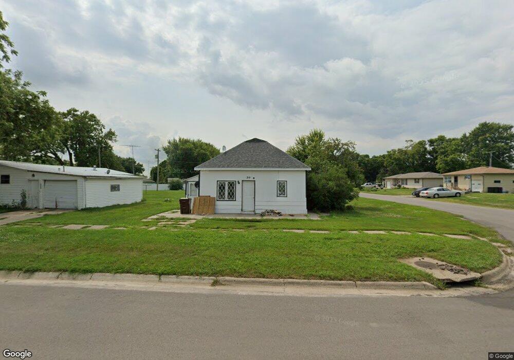
210 N Logan St Osmond, NE 68765
Estimated Value: $61,000 - $113,000
2
Beds
1
Bath
624
Sq Ft
$139/Sq Ft
Est. Value
About This Home
Small 2 bedroom home in great community. Osmond has a grocery store, great park, pool, hospital, restaurant, and much more. Pets allowed with fee.
Ownership History
Date
Name
Owned For
Owner Type
Purchase Details
Closed on
Dec 9, 2022
Sold by
Howard Dale L and Howard Verona L
Bought by
Defor Timothy and Defor Julie
Current Estimated Value
Home Financials for this Owner
Home Financials are based on the most recent Mortgage that was taken out on this home.
Original Mortgage
$60,000
Outstanding Balance
$58,079
Interest Rate
6.95%
Mortgage Type
Construction
Estimated Equity
$28,702
Create a Home Valuation Report for This Property
The Home Valuation Report is an in-depth analysis detailing your home's value as well as a comparison with similar homes in the area
Home Values in the Area
Average Home Value in this Area
Purchase History
| Date | Buyer | Sale Price | Title Company |
|---|---|---|---|
| Defor Timothy | $80,000 | -- |
Source: Public Records
Mortgage History
| Date | Status | Borrower | Loan Amount |
|---|---|---|---|
| Open | Defor Timothy | $60,000 | |
| Closed | Defor Timothy | $20,000 |
Source: Public Records
Property History
| Date | Event | Price | List to Sale | Price per Sq Ft |
|---|---|---|---|---|
| 02/03/2025 02/03/25 | Off Market | -- | -- | -- |
| 01/29/2025 01/29/25 | For Rent | -- | -- | -- |
Tax History Compared to Growth
Tax History
| Year | Tax Paid | Tax Assessment Tax Assessment Total Assessment is a certain percentage of the fair market value that is determined by local assessors to be the total taxable value of land and additions on the property. | Land | Improvement |
|---|---|---|---|---|
| 2025 | $405 | $33,870 | $9,375 | $24,495 |
| 2024 | $405 | $30,705 | $9,375 | $21,330 |
| 2023 | $379 | $22,325 | $3,750 | $18,575 |
| 2022 | $410 | $22,325 | $3,750 | $18,575 |
| 2021 | $386 | $20,965 | $3,750 | $17,215 |
| 2020 | $375 | $20,295 | $3,750 | $16,545 |
| 2019 | $355 | $20,295 | $3,750 | $16,545 |
| 2018 | $332 | $19,520 | $3,750 | $15,770 |
| 2017 | $319 | $18,780 | $3,750 | $15,030 |
| 2016 | $307 | $18,780 | $3,750 | $15,030 |
| 2015 | $306 | $18,780 | $3,750 | $15,030 |
| 2014 | $294 | $16,425 | $3,750 | $12,675 |
Source: Public Records
Map
Nearby Homes
- 301 N Logan St
- 304 W 2nd St
- 510 N State St
- 610 N Maple St
- 708 N Maple St
- 542 Nebraska 13
- 553 Ave 867th
- 857th Rd 548th Ave
- 854th Rd 551st Ave
- 208 N 9th St
- 403 N 3rd St
- 802 S Bismark St
- 301 E Roosevelt St
- 409 N Elm St
- 106 N West St
- 104 N West St
- 702 E Norris St
- 108 N Plum St
- 4.5 Acres 552nd Ave
- 703 E Clark St