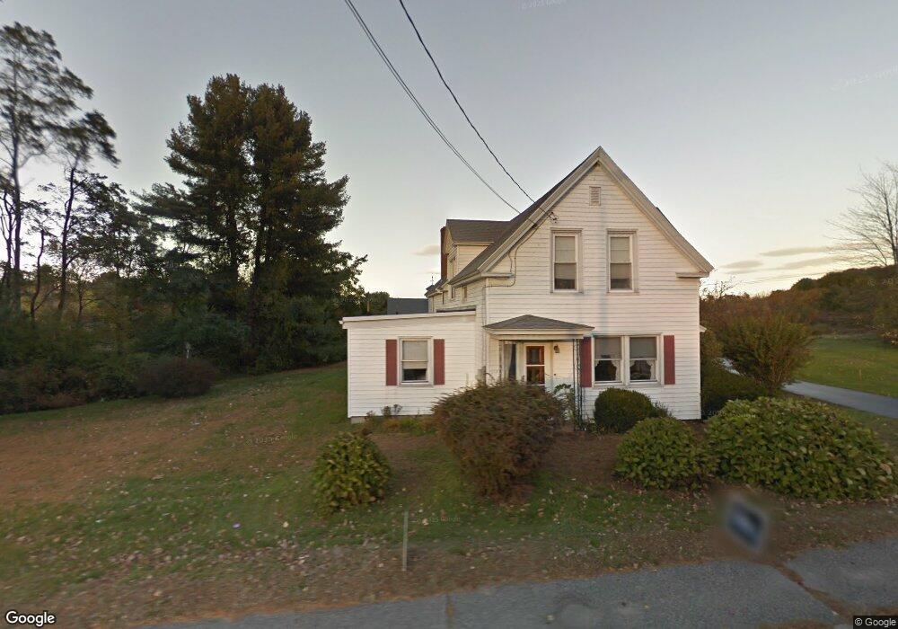
210 Pine Point Rd Scarborough, ME 04074
Estimated Value: $663,000 - $886,000
4
Beds
2
Baths
2,684
Sq Ft
$285/Sq Ft
Est. Value
About This Home
This home is located at 210 Pine Point Rd, Scarborough, ME 04074 and is currently estimated at $764,010, approximately $284 per square foot. 210 Pine Point Rd is a home with nearby schools including Scarborough High School and Cornerstone Baptist Academy.
Ownership History
Date
Name
Owned For
Owner Type
Purchase Details
Closed on
May 10, 2013
Sold by
Roach Dale E and Roach Patricia A
Bought by
Roach Dale E and Roach Patricia A
Current Estimated Value
Home Financials for this Owner
Home Financials are based on the most recent Mortgage that was taken out on this home.
Original Mortgage
$113,000
Interest Rate
3.6%
Mortgage Type
Commercial
Create a Home Valuation Report for This Property
The Home Valuation Report is an in-depth analysis detailing your home's value as well as a comparison with similar homes in the area
Home Values in the Area
Average Home Value in this Area
Purchase History
| Date | Buyer | Sale Price | Title Company |
|---|---|---|---|
| Roach Dale E | -- | -- |
Source: Public Records
Mortgage History
| Date | Status | Borrower | Loan Amount |
|---|---|---|---|
| Closed | Roach Dale E | $113,000 |
Source: Public Records
Tax History Compared to Growth
Tax History
| Year | Tax Paid | Tax Assessment Tax Assessment Total Assessment is a certain percentage of the fair market value that is determined by local assessors to be the total taxable value of land and additions on the property. | Land | Improvement |
|---|---|---|---|---|
| 2025 | $7,165 | $632,400 | $214,800 | $417,600 |
| 2024 | $6,912 | $632,400 | $214,800 | $417,600 |
| 2023 | $6,904 | $432,300 | $140,300 | $292,000 |
| 2022 | $6,653 | $432,300 | $140,300 | $292,000 |
| 2021 | $6,097 | $430,900 | $138,900 | $292,000 |
| 2020 | $6,032 | $430,900 | $138,900 | $292,000 |
| 2019 | $6,367 | $433,100 | $138,900 | $294,200 |
| 2017 | $4,861 | $320,800 | $198,500 | $122,300 |
| 2016 | $5,107 | $320,800 | $198,500 | $122,300 |
| 2015 | $4,969 | $320,800 | $198,500 | $122,300 |
| 2014 | $4,602 | $320,800 | $198,500 | $122,300 |
| 2013 | -- | $320,800 | $198,500 | $122,300 |
Source: Public Records
Map
Nearby Homes
- 4 Sylvan Rd
- 11 Hillside Ave
- 49 Seavey Landing Rd
- 166 Pine Point Rd
- 44 Jones Creek Dr
- 4 High Point Rd
- 68 Jones Creek Dr
- 6 Overlook Dr Unit 1
- 22 Salt Point Dr Unit 23
- 215 E Grand Ave Unit 405
- Lot 5 Jean's Way
- 31 Old Blue Point Rd
- 205 E Grand Ave Unit 7D
- 2 Lindas Way
- 4 Sea Oaks Dr Unit 2
- 2 Sea Oaks Dr Unit 1
- 81 Creeks Edge Dr
- 11 Sea Oaks Dr Unit 2
- 8 Sea Oaks Dr Unit 3
- 626 Us Route 1
- 212 Pine Point Rd
- 207 Pine Point Rd
- 211 Pine Point Rd
- 203 Pine Point
- 203 Pine Point Rd
- 215 Pine Point Rd
- 216 Pine Point Rd
- 2 Staddle Ln
- 218 Pine Point Rd
- 219 Pine Point Rd
- 4 Staddle Ln
- 220 Pine Point Rd
- 198 Pine Point Rd
- 6 Staddle Ln
- 197 Pine Point Rd
- 1 Chickadee Ln
- 196 Pine Point Rd
- 213 Pine Point Rd
- 8 Staddle Ln
- 224 Pine Point Rd