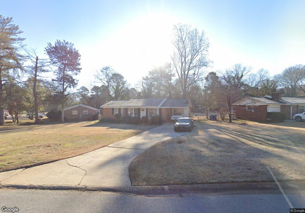
210 Rumson Rd Athens, GA 30605
Estimated Value: $233,784 - $279,000
Studio
1
Bath
1,218
Sq Ft
$215/Sq Ft
Est. Value
About This Home
This home is located at 210 Rumson Rd, Athens, GA 30605 and is currently estimated at $261,446, approximately $214 per square foot. 210 Rumson Rd is a home located in Clarke County with nearby schools including Barnett Shoals Elementary School, Hilsman Middle School, and Cedar Shoals High School.
Ownership History
Date
Name
Owned For
Owner Type
Purchase Details
Closed on
Aug 23, 2022
Sold by
Keller Carolyn S
Bought by
The Carolyn Keller Liv Tr
Current Estimated Value
Purchase Details
Closed on
Jun 13, 2001
Sold by
Leander Brian S Clesete A Lean
Bought by
Keller Carolyn S
Purchase Details
Closed on
Jul 25, 1997
Sold by
Moles Rhonda Lynn
Bought by
Leander Brian S Clesete A Leander G
Purchase Details
Closed on
Feb 15, 1994
Sold by
Leff Adam A and Laura Gunn Leff
Bought by
Moles Rhonda Lynn
Create a Home Valuation Report for This Property
The Home Valuation Report is an in-depth analysis detailing your home's value as well as a comparison with similar homes in the area
Purchase History
| Date | Buyer | Sale Price | Title Company |
|---|---|---|---|
| The Carolyn Keller Liv Tr | -- | -- | |
| Keller Carolyn S | $107,000 | -- | |
| Leander Brian S Clesete A Leander G | $79,900 | -- | |
| Moles Rhonda Lynn | $48,900 | -- |
Source: Public Records
Tax History
| Year | Tax Paid | Tax Assessment Tax Assessment Total Assessment is a certain percentage of the fair market value that is determined by local assessors to be the total taxable value of land and additions on the property. | Land | Improvement |
|---|---|---|---|---|
| 2025 | $2,326 | $93,013 | $12,000 | $81,013 |
| 2024 | $2,326 | $87,482 | $12,000 | $75,482 |
| 2023 | $1,454 | $81,534 | $12,000 | $69,534 |
| 2022 | $1,803 | $66,511 | $10,400 | $56,111 |
| 2021 | $1,421 | $52,175 | $10,400 | $41,775 |
| 2020 | $1,365 | $50,500 | $10,400 | $40,100 |
| 2019 | $1,323 | $48,975 | $10,400 | $38,575 |
| 2018 | $1,153 | $43,962 | $10,400 | $33,562 |
| 2017 | $941 | $37,715 | $10,400 | $27,315 |
| 2016 | $877 | $35,838 | $10,400 | $25,438 |
| 2015 | $919 | $37,016 | $10,400 | $26,616 |
| 2014 | $932 | $37,357 | $10,400 | $26,957 |
Source: Public Records
Map
Nearby Homes
- 150 Rumson Rd
- 2535 Barnett Shoals Rd
- 189 Ashbrook Dr
- 331 Greencrest Dr
- 140 Ashbrook Dr
- 352 Greencrest Dr
- 109 Layla Ct
- 148 Warren Way
- 140 Whitehall Rd
- 0 Barnett Shoals Rd Unit Lot 1
- 119 Pine Ridge Trace
- 431 College Cir
- 325 Segrest Cir
- 400 Ansley Dr
- 625 Forest Rd
- 256 Scandia Cir
- 1055 College Station Rd
- 375 Segrest Cir
- 337 Georgetown Dr
- 365 Whitehall Rd
Your Personal Tour Guide
Ask me questions while you tour the home.