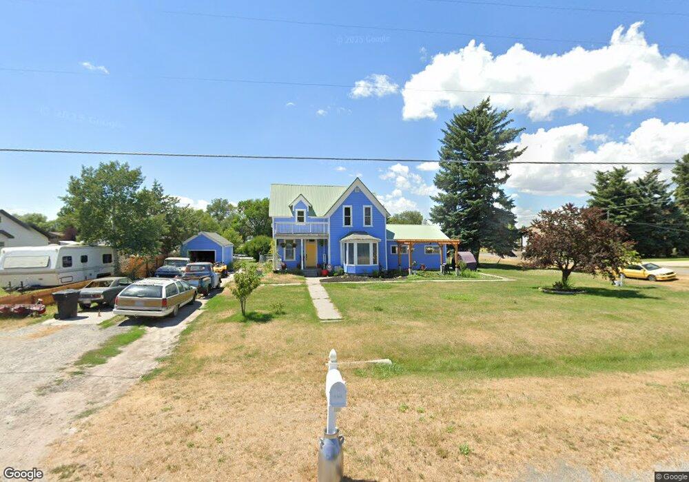
210 S Main St Lewiston, UT 84320
Estimated Value: $370,000 - $453,000
5
Beds
2
Baths
2,502
Sq Ft
$163/Sq Ft
Est. Value
About This Home
This home is located at 210 S Main St, Lewiston, UT 84320 and is currently estimated at $407,172, approximately $162 per square foot. 210 S Main St is a home located in Cache County with nearby schools including Lewiston School, White Pine Middle School, and North Cache Middle School.
Ownership History
Date
Name
Owned For
Owner Type
Purchase Details
Closed on
Dec 10, 2024
Sold by
Bagnell Stephanie
Bought by
Bagnell Stephanie and Ritter Derek Matthew
Current Estimated Value
Purchase Details
Closed on
Feb 24, 2022
Sold by
Barrus Lisa
Bought by
Bagnell Stephanie
Home Financials for this Owner
Home Financials are based on the most recent Mortgage that was taken out on this home.
Original Mortgage
$180,250
Interest Rate
3.69%
Mortgage Type
New Conventional
Purchase Details
Closed on
Dec 29, 2021
Sold by
Barrus Lisa
Bought by
Barrus Lisa and Bagnell Stephanie
Home Financials for this Owner
Home Financials are based on the most recent Mortgage that was taken out on this home.
Original Mortgage
$180,250
Interest Rate
3.69%
Mortgage Type
New Conventional
Purchase Details
Closed on
Dec 22, 2021
Sold by
210 N Main Street Trust and Powell Renee
Bought by
Barrus Lisa
Home Financials for this Owner
Home Financials are based on the most recent Mortgage that was taken out on this home.
Original Mortgage
$173,250
Interest Rate
2.98%
Mortgage Type
New Conventional
Purchase Details
Closed on
Jul 29, 2021
Sold by
210 N Main Street Trust and Powell Renee
Bought by
210 N Main Street Trust and Powell
Purchase Details
Closed on
Mar 21, 2020
Sold by
Quigley James A
Bought by
Powell Renee and 210 N Main Street Trust
Purchase Details
Closed on
Jul 28, 2006
Sold by
Marlin Linda Jean and Estate Of Harold Hugh Merritt
Bought by
Kent Callan Phillip and Kent Amber
Home Financials for this Owner
Home Financials are based on the most recent Mortgage that was taken out on this home.
Original Mortgage
$99,000
Interest Rate
6.69%
Mortgage Type
New Conventional
Purchase Details
Closed on
Apr 19, 2001
Sold by
Kent Callan Phillip and Kent Amber
Bought by
Quigley James A
Home Financials for this Owner
Home Financials are based on the most recent Mortgage that was taken out on this home.
Original Mortgage
$116,745
Interest Rate
3.75%
Mortgage Type
FHA
Create a Home Valuation Report for This Property
The Home Valuation Report is an in-depth analysis detailing your home's value as well as a comparison with similar homes in the area
Home Values in the Area
Average Home Value in this Area
Purchase History
| Date | Buyer | Sale Price | Title Company |
|---|---|---|---|
| Bagnell Stephanie | -- | Advanced Title | |
| Bagnell Stephanie | -- | Advanced Title | |
| Bagnell Stephanie | -- | Advanced Title | |
| Barrus Lisa | -- | None Listed On Document | |
| Barrus Lisa | -- | Gt Title Services | |
| Barrus Lisa | -- | Gt Title Services | |
| 210 N Main Street Trust | -- | Advanced Title | |
| Powell Renee | -- | Advanced Title | |
| Kent Callan Phillip | -- | Cache Title Company | |
| Quigley James A | -- | Advanced Title |
Source: Public Records
Mortgage History
| Date | Status | Borrower | Loan Amount |
|---|---|---|---|
| Previous Owner | Bagnell Stephanie | $180,250 | |
| Previous Owner | Barrus Lisa | $173,250 | |
| Previous Owner | Kent Callan Phillip | $99,000 | |
| Previous Owner | Quigley James A | $116,745 |
Source: Public Records
Tax History Compared to Growth
Tax History
| Year | Tax Paid | Tax Assessment Tax Assessment Total Assessment is a certain percentage of the fair market value that is determined by local assessors to be the total taxable value of land and additions on the property. | Land | Improvement |
|---|---|---|---|---|
| 2025 | $1,713 | $221,465 | $0 | $0 |
| 2024 | $1,892 | $225,910 | $0 | $0 |
| 2023 | $2,020 | $226,565 | $0 | $0 |
| 2022 | $1,433 | $152,940 | $0 | $0 |
| 2021 | $1,292 | $213,307 | $51,400 | $161,907 |
| 2020 | $999 | $157,544 | $33,000 | $124,544 |
| 2019 | $1,046 | $157,544 | $33,000 | $124,544 |
| 2018 | $979 | $144,200 | $33,000 | $111,200 |
| 2017 | $857 | $66,990 | $0 | $0 |
| 2016 | $865 | $66,990 | $0 | $0 |
| 2015 | $856 | $66,440 | $0 | $0 |
| 2014 | $835 | $66,440 | $0 | $0 |
| 2013 | -- | $66,440 | $0 | $0 |
Source: Public Records
Map
Nearby Homes
- 50 W 300 S
- 80 W 300 S
- 930 S 800 E
- 12506 N 525 E Unit 6
- 12489 N 525 E
- 12455 N 525 E Unit 1
- 12455 N 525 E
- 12506 N 525 E
- 12484 N 525 E Unit 7
- 12521 N 525 E
- 12518 N 525 E Unit 5
- 12489 N 525 E Unit 2
- 2400 W
- 12484 N 525 E
- 12518 N 525 E
- 12456 N 525 E Unit 8
- 12521 N 525 E Unit 3
- 12456 N 525 E
- 435 E 1600 S Unit EAST
- 338 E 1600 S