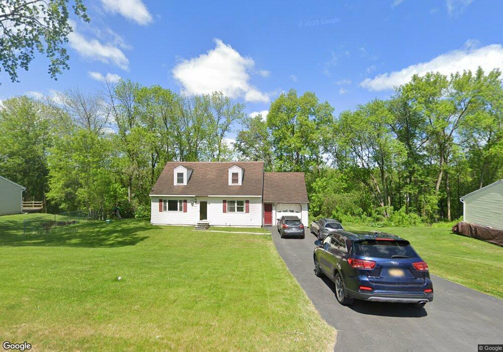
210 Samantha Dr Fort Edward, NY 12828
Estimated Value: $252,644 - $276,000
3
Beds
2
Baths
1,296
Sq Ft
$206/Sq Ft
Est. Value
About This Home
This home is located at 210 Samantha Dr, Fort Edward, NY 12828 and is currently estimated at $267,411, approximately $206 per square foot. 210 Samantha Dr is a home located in Washington County with nearby schools including Fort Edward School.
Ownership History
Date
Name
Owned For
Owner Type
Purchase Details
Closed on
Mar 15, 2011
Sold by
Cross Peggy
Bought by
Hatch Peggy
Current Estimated Value
Home Financials for this Owner
Home Financials are based on the most recent Mortgage that was taken out on this home.
Original Mortgage
$138,813
Outstanding Balance
$6,289
Interest Rate
4.5%
Mortgage Type
FHA
Estimated Equity
$261,122
Purchase Details
Closed on
Aug 21, 2006
Sold by
White Bruce
Bought by
Cross Peggy
Home Financials for this Owner
Home Financials are based on the most recent Mortgage that was taken out on this home.
Original Mortgage
$139,046
Interest Rate
6.52%
Mortgage Type
Purchase Money Mortgage
Purchase Details
Closed on
Mar 24, 2006
Sold by
Poulos Gus
Bought by
White Bruce
Home Financials for this Owner
Home Financials are based on the most recent Mortgage that was taken out on this home.
Original Mortgage
$75,000
Interest Rate
6.28%
Mortgage Type
Purchase Money Mortgage
Purchase Details
Closed on
May 23, 2001
Sold by
Shelter Homes Ltd
Bought by
Poulos Gus T
Create a Home Valuation Report for This Property
The Home Valuation Report is an in-depth analysis detailing your home's value as well as a comparison with similar homes in the area
Home Values in the Area
Average Home Value in this Area
Purchase History
| Date | Buyer | Sale Price | Title Company |
|---|---|---|---|
| Hatch Peggy | -- | -- | |
| Cross Peggy | $140,400 | Suzanne Spector-Tougas | |
| White Bruce | $100,000 | Edward Connell | |
| Poulos Gus T | $84,750 | Tim Elliott |
Source: Public Records
Mortgage History
| Date | Status | Borrower | Loan Amount |
|---|---|---|---|
| Open | Hatch Peggy | $138,813 | |
| Previous Owner | Cross Peggy | $139,046 | |
| Previous Owner | White Bruce | $75,000 |
Source: Public Records
Tax History Compared to Growth
Tax History
| Year | Tax Paid | Tax Assessment Tax Assessment Total Assessment is a certain percentage of the fair market value that is determined by local assessors to be the total taxable value of land and additions on the property. | Land | Improvement |
|---|---|---|---|---|
| 2024 | $7,024 | $200,000 | $30,800 | $169,200 |
| 2023 | $7,050 | $200,000 | $30,800 | $169,200 |
| 2022 | $6,849 | $200,000 | $30,800 | $169,200 |
| 2021 | $6,484 | $113,300 | $15,500 | $97,800 |
| 2020 | $6,020 | $113,300 | $15,500 | $97,800 |
| 2019 | $5,662 | $113,300 | $15,500 | $97,800 |
| 2018 | $5,662 | $113,300 | $15,500 | $97,800 |
| 2017 | $4,823 | $113,300 | $15,500 | $97,800 |
| 2016 | $4,567 | $113,300 | $15,500 | $97,800 |
| 2015 | -- | $113,300 | $15,500 | $97,800 |
| 2014 | -- | $113,300 | $15,500 | $97,800 |
Source: Public Records
Map
Nearby Homes
- L 75 Frederick Dr
- L1.1 Drifting Ridge Rd
- 418 Tori Trace
- 44-46 Notre Dame St
- 420 Tori Trace
- 415 Tori Trace
- 411 Tori Trace
- 410 Tori Trace
- 3040 County Route 46
- 99 State Route 197
- 11 Bridge St Unit 13
- 109-111 Broadway
- 8 Bridge St
- 82 East St
- 27-29 Taylor St
- 2434 State Route 4
- 12 Laurel Rd
- 24 Wing St
- 4 Keating Ave
- 192 Broadway
- 212 Samantha Dr
- 2 Samantha Dr
- 206 Samantha Dr
- 207 Samantha Dr
- 214 Samantha Dr
- 302 Andrew Ln
- 204 Samantha Dr
- 216 Samantha Dr
- 216 Samantha Dr
- 203 Samantha Dr
- 301 Andrew Ln
- 218 Samantha Dr
- 20 Frederick Dr
- 215 Samantha Dr
- 202 Samantha Dr
- 304 Andrew Ln
- 22 Frederick Dr
- 220 Samantha Dr
- 220 Samantha Dr
- 303 Andrew Ln