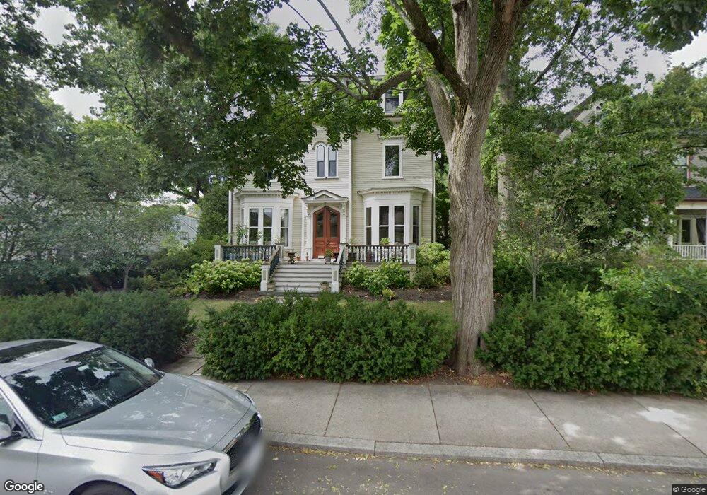
210 Savin Hill Ave Dorchester, MA 02125
Savin Hill NeighborhoodEstimated Value: $1,301,000 - $1,789,000
5
Beds
2
Baths
4,324
Sq Ft
$373/Sq Ft
Est. Value
About This Home
This home is located at 210 Savin Hill Ave, Dorchester, MA 02125 and is currently estimated at $1,613,180, approximately $373 per square foot. 210 Savin Hill Ave is a home located in Suffolk County with nearby schools including Boston Collegiate Charter School, Pope John Paul II Catholic Academy Columbia Campus, and Boston College High School.
Ownership History
Date
Name
Owned For
Owner Type
Purchase Details
Closed on
Jul 24, 2013
Sold by
Lord Collin H
Bought by
Hoag Kristine
Current Estimated Value
Purchase Details
Closed on
Dec 31, 1992
Sold by
Nangelsdorf Carolyn E and Nagelsdorf Chris W
Bought by
Lord Collin H and Hoag Kristine
Create a Home Valuation Report for This Property
The Home Valuation Report is an in-depth analysis detailing your home's value as well as a comparison with similar homes in the area
Home Values in the Area
Average Home Value in this Area
Purchase History
| Date | Buyer | Sale Price | Title Company |
|---|---|---|---|
| Hoag Kristine | -- | -- | |
| Lord Collin H | $90,000 | -- |
Source: Public Records
Mortgage History
| Date | Status | Borrower | Loan Amount |
|---|---|---|---|
| Previous Owner | Lord Collin H | $110,000 | |
| Previous Owner | Lord Collin H | $445,500 | |
| Previous Owner | Lord Collin H | $243,000 |
Source: Public Records
Tax History Compared to Growth
Tax History
| Year | Tax Paid | Tax Assessment Tax Assessment Total Assessment is a certain percentage of the fair market value that is determined by local assessors to be the total taxable value of land and additions on the property. | Land | Improvement |
|---|---|---|---|---|
| 2025 | $18,097 | $1,562,800 | $591,800 | $971,000 |
| 2024 | $15,427 | $1,415,300 | $393,800 | $1,021,500 |
| 2023 | $14,763 | $1,374,600 | $382,500 | $992,100 |
| 2022 | $14,238 | $1,308,600 | $364,100 | $944,500 |
| 2021 | $13,380 | $1,254,000 | $353,500 | $900,500 |
| 2020 | $12,072 | $1,143,200 | $349,800 | $793,400 |
| 2019 | $11,199 | $1,062,500 | $289,900 | $772,600 |
| 2018 | $10,409 | $993,200 | $289,900 | $703,300 |
| 2017 | $9,562 | $902,900 | $289,900 | $613,000 |
| 2016 | $9,643 | $876,600 | $289,900 | $586,700 |
| 2015 | $9,924 | $819,500 | $213,800 | $605,700 |
| 2014 | $9,728 | $773,300 | $213,800 | $559,500 |
Source: Public Records
Map
Nearby Homes
- 175 Savin Hill Ave Unit 3
- 141 Savin Hill Ave Unit C23
- 141 Savin Hill Ave Unit A22
- 42 Grampian Way
- 10 Linda Ln Unit 3-6
- 243 D Savin Hill Ave
- 9 Sydney St Unit 301
- 9 Sydney St Unit 1
- 10 Sydney St Unit 7
- 86 Savin Hill Ave Unit 3
- 79 Sydney St
- 4 Saxton St
- 73 Tuttle St
- 72 Tuttle St Unit 3
- 58 Saxton St Unit 2
- 84 Romsey St Unit 3
- 16 Hallam St
- 9 Hallam St Unit 3
- 62 Romsey St Unit 2
- 11 Savin Hill Ave
- 206 Savin Hill Ave
- 212 Savin Hill Ave
- 209 Savin Hill Ave Unit 1
- 209 Savin Hill Ave
- 211 Savin Hill Ave
- 211 Savin Hill Ave Unit 1
- 216 Savin Hill Ave
- 150 Grampian Way
- 160 Grampian Way
- 207 Savin Hill Ave
- 174 Grampian Way Unit 2R
- 174 Grampian Way Unit 1R
- 174 Grampian Way Unit 3
- 174 Grampian Way Unit 2
- 174 Grampian Way Unit 1
- 174 Grampian Way
- 174 Grampian Way Unit 4
- 174 Grampian Way Unit 5
- 202 Savin Hill Ave
- 126 Grampian Way