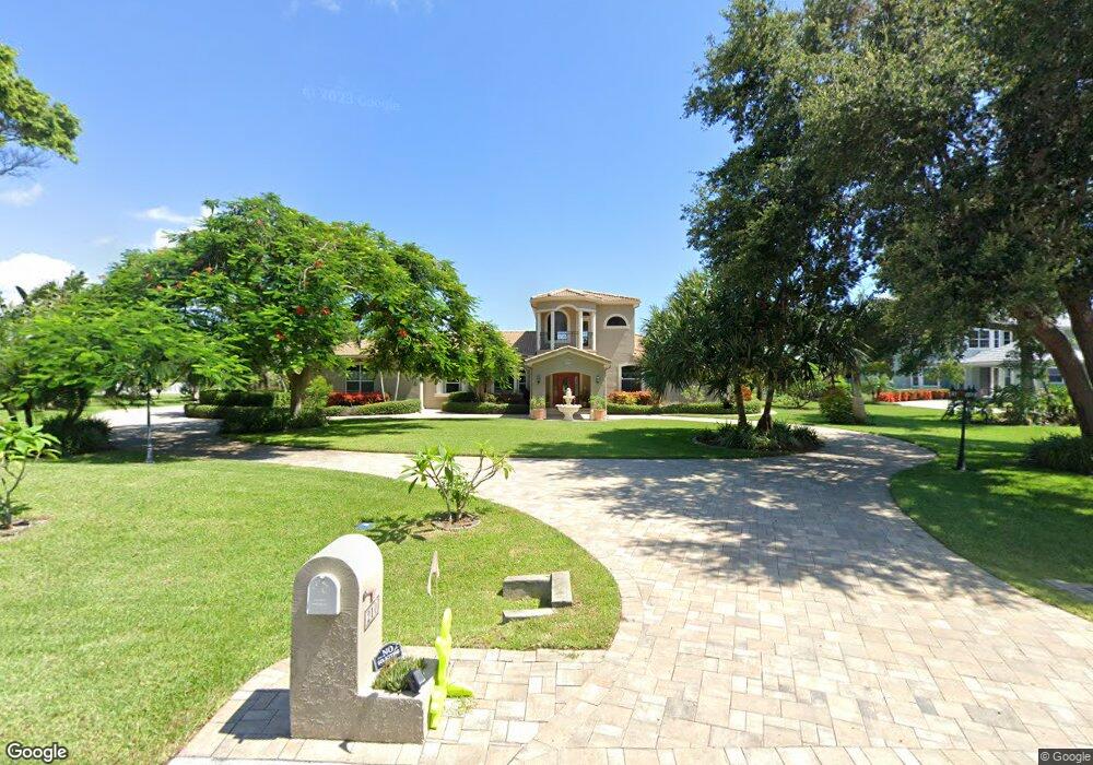
210 Stewart Dr Merritt Island, FL 32952
Estimated Value: $1,355,017 - $1,531,000
4
Beds
3
Baths
4,308
Sq Ft
$336/Sq Ft
Est. Value
About This Home
This home is located at 210 Stewart Dr, Merritt Island, FL 32952 and is currently estimated at $1,446,754, approximately $335 per square foot. 210 Stewart Dr is a home located in Brevard County with nearby schools including Tropical Elementary School, Thomas Jefferson Middle School, and Merritt Island High School.
Ownership History
Date
Name
Owned For
Owner Type
Purchase Details
Closed on
Apr 14, 2016
Sold by
Irrevocable Smith Philip C
Bought by
Smith Douglas R
Current Estimated Value
Purchase Details
Closed on
Dec 23, 2004
Sold by
Dusenbery Ben and Dusenbery Leticia
Bought by
Smith Douglas R and Smith Pamela M
Home Financials for this Owner
Home Financials are based on the most recent Mortgage that was taken out on this home.
Original Mortgage
$800,000
Interest Rate
5.67%
Create a Home Valuation Report for This Property
The Home Valuation Report is an in-depth analysis detailing your home's value as well as a comparison with similar homes in the area
Home Values in the Area
Average Home Value in this Area
Purchase History
| Date | Buyer | Sale Price | Title Company |
|---|---|---|---|
| Smith Douglas R | -- | Attorney | |
| Smith Douglas R | $1,050,000 | Security First Title Partner |
Source: Public Records
Mortgage History
| Date | Status | Borrower | Loan Amount |
|---|---|---|---|
| Previous Owner | Smith Douglas R | $800,000 |
Source: Public Records
Tax History Compared to Growth
Tax History
| Year | Tax Paid | Tax Assessment Tax Assessment Total Assessment is a certain percentage of the fair market value that is determined by local assessors to be the total taxable value of land and additions on the property. | Land | Improvement |
|---|---|---|---|---|
| 2025 | $7,557 | $621,600 | -- | -- |
| 2024 | $7,517 | $604,090 | -- | -- |
| 2023 | $7,517 | $586,500 | $0 | $0 |
| 2022 | $6,731 | $543,210 | $0 | $0 |
| 2021 | $7,109 | $527,390 | $0 | $0 |
| 2020 | $7,078 | $520,110 | $0 | $0 |
| 2019 | $7,042 | $506,700 | $0 | $0 |
| 2018 | $7,087 | $497,260 | $0 | $0 |
| 2017 | $7,204 | $487,040 | $0 | $0 |
| 2016 | $7,365 | $477,030 | $150,000 | $327,030 |
| 2015 | $7,620 | $473,720 | $150,000 | $323,720 |
| 2014 | $7,689 | $469,960 | $100,000 | $369,960 |
Source: Public Records
Map
Nearby Homes
- 190 Stewart Dr
- 5160 Del Sol Dr
- 5140 Del Sol Dr
- 155 Hacienda Dr
- 5180 Calmes Way
- 4760 Honeyridge Ln
- 4395 Crooked Mile Rd
- 735 Pilot Ln Unit 314
- 735 Pilot Ln Unit 812
- 735 Pilot Ln Unit 408
- 735 Pilot Ln Unit 603
- 735 Pilot Ln Unit 614
- 735 Pilot Ln Unit 611
- 735 Pilot Ln Unit 908
- 735 Pilot Ln Unit 606
- 735 Pilot Ln Unit 1004
- 735 Pilot Ln Unit 510
- 735 Pilot Ln Unit 814
- 4320 Crooked Mile Rd
- 145 Crispin St
- 200 Stewart Dr
- 240 Stewart Dr
- 205 Stewart Dr
- 215 Stewart Dr
- 225 Stewart Dr
- 235 Stewart Dr
- 180 Stewart Dr
- 265 Stewart Dr
- 220 Hacienda Dr
- 255 Stewart Dr
- 215 Hacienda Dr
- 245 Stewart Dr
- 0 Del Sol Unit 671406
- 170 Stewart Dr
- 200 Hacienda Dr
- 185 Stewart Dr
- 5155 Del Sol Dr
- 5040 Valle Collina Ln
- 205 Hacienda Dr
- 180 Hacienda Dr