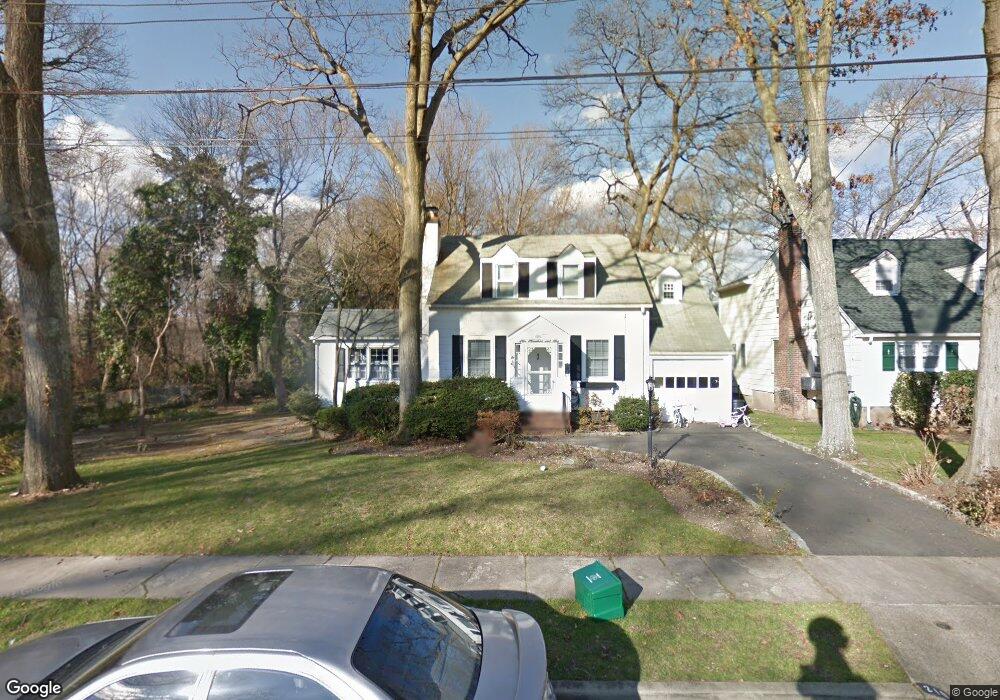
210 Stuyvesant Ave Merrick, NY 11566
Estimated Value: $616,000 - $858,703
3
Beds
2
Baths
1,445
Sq Ft
$510/Sq Ft
Est. Value
About This Home
This home is located at 210 Stuyvesant Ave, Merrick, NY 11566 and is currently estimated at $737,352, approximately $510 per square foot. 210 Stuyvesant Ave is a home located in Nassau County with nearby schools including Merrick Avenue Middle School, Sanford H Calhoun High School, and Grace Christian Academy.
Ownership History
Date
Name
Owned For
Owner Type
Purchase Details
Closed on
Nov 19, 2015
Sold by
Kerning Daniel and Kerning Heather
Bought by
Ramlowtan Anil and Prashad-Ramlowtan Rookmin
Current Estimated Value
Purchase Details
Closed on
Sep 19, 2011
Sold by
Tanz Daniel and Brandfon Barbara
Bought by
Kerning Daniel and Kerning Heather
Purchase Details
Closed on
Nov 11, 1999
Sold by
Tanz Elliott and Tanz Jean
Bought by
Tanz Daniel and Brandfon Barbara
Create a Home Valuation Report for This Property
The Home Valuation Report is an in-depth analysis detailing your home's value as well as a comparison with similar homes in the area
Home Values in the Area
Average Home Value in this Area
Purchase History
| Date | Buyer | Sale Price | Title Company |
|---|---|---|---|
| Ramlowtan Anil | $339,900 | Old Republic National Title | |
| Kerning Daniel | $370,000 | -- | |
| Tanz Daniel | -- | -- |
Source: Public Records
Tax History Compared to Growth
Tax History
| Year | Tax Paid | Tax Assessment Tax Assessment Total Assessment is a certain percentage of the fair market value that is determined by local assessors to be the total taxable value of land and additions on the property. | Land | Improvement |
|---|---|---|---|---|
| 2025 | $16,786 | $553 | $265 | $288 |
| 2024 | $3,836 | $553 | $265 | $288 |
| 2023 | $15,188 | $554 | $265 | $289 |
| 2022 | $15,188 | $553 | $265 | $288 |
| 2021 | $20,388 | $553 | $265 | $288 |
| 2020 | $14,841 | $715 | $635 | $80 |
| 2019 | $13,601 | $715 | $635 | $80 |
| 2018 | $12,774 | $715 | $0 | $0 |
| 2017 | $10,793 | $938 | $635 | $303 |
| 2016 | $14,807 | $938 | $635 | $303 |
| 2015 | $3,722 | $938 | $635 | $303 |
| 2014 | $3,722 | $938 | $635 | $303 |
| 2013 | $3,503 | $933 | $635 | $298 |
Source: Public Records
Map
Nearby Homes
- 25 Babylon Turnpike
- 179 Commonwealth Ave
- 1690 Argyle Rd
- 78 Jesse St
- 1818 Gormley Ave
- 1729 Gormley Ave
- 45 Lakeview Ave
- 2291 Girard Place
- 2991 Girard Place
- 10 Central Pkwy
- 1938 Meadowbrook Rd
- 1707 Carroll Ave
- 96 Thelma Ave
- 33 Willow Ave
- 1674 Birch Dr
- 1931 Miller Place
- 131 Gregory Ave
- 6 Frederick Ave
- 49 Princeton Place
- 251 Grand Ave
- 208 Stuyvesant Ave
- 206 Stuyvesant Ave
- 211 Stuyvesant Ave
- 204 Stuyvesant Ave
- 209 Stuyvesant Ave
- 2160 Babylon Turnpike
- 205 Stuyvesant Ave
- 2164 Babylon Turnpike
- 2156 Babylon Turnpike
- 65 Babylon Turnpike
- 2170 Babylon Turnpike
- 203 Stuyvesant Ave
- 45 Babylon Turnpike
- 190 Bedford Ave
- 192 Bedford Ave
- 69 Babylon Turnpike
- 188 Bedford Ave
- 201 Stuyvesant Ave
- 186 Bedford Ave
- 1 Bedford Ave