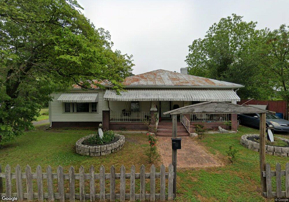
210 W Boundary St La Grange, NC 28551
Estimated Value: $90,000 - $273,000
3
Beds
1
Bath
1,285
Sq Ft
$111/Sq Ft
Est. Value
About This Home
This home is located at 210 W Boundary St, La Grange, NC 28551 and is currently estimated at $142,804, approximately $111 per square foot. 210 W Boundary St is a home located in Lenoir County with nearby schools including La Grange Elementary School, E.B. Frink Middle School, and North Lenoir High School.
Ownership History
Date
Name
Owned For
Owner Type
Purchase Details
Closed on
Mar 2, 2015
Sold by
Moore Martin Travis and Moore Christy Rose
Bought by
Hardy Jack T and Burgin Christel A
Current Estimated Value
Home Financials for this Owner
Home Financials are based on the most recent Mortgage that was taken out on this home.
Original Mortgage
$25,500
Interest Rate
3.75%
Mortgage Type
Seller Take Back
Purchase Details
Closed on
Aug 25, 2009
Sold by
National City Bank
Bought by
Moore Tracy and Moore Martin Travis
Purchase Details
Closed on
Sep 30, 2008
Sold by
Tann Luciana and Tann Bobby N Ray
Bought by
National City Bank
Create a Home Valuation Report for This Property
The Home Valuation Report is an in-depth analysis detailing your home's value as well as a comparison with similar homes in the area
Home Values in the Area
Average Home Value in this Area
Purchase History
| Date | Buyer | Sale Price | Title Company |
|---|---|---|---|
| Hardy Jack T | $28,500 | None Available | |
| Moore Tracy | $14,000 | -- | |
| National City Bank | $53,000 | None Available |
Source: Public Records
Mortgage History
| Date | Status | Borrower | Loan Amount |
|---|---|---|---|
| Closed | Hardy Jack T | $25,500 |
Source: Public Records
Tax History Compared to Growth
Tax History
| Year | Tax Paid | Tax Assessment Tax Assessment Total Assessment is a certain percentage of the fair market value that is determined by local assessors to be the total taxable value of land and additions on the property. | Land | Improvement |
|---|---|---|---|---|
| 2025 | $1,068 | $106,459 | $33,366 | $73,093 |
| 2024 | $458 | $33,237 | $8,704 | $24,533 |
| 2023 | $458 | $33,237 | $8,704 | $24,533 |
| 2022 | $458 | $33,237 | $8,704 | $24,533 |
| 2021 | $458 | $33,237 | $8,704 | $24,533 |
| 2020 | $458 | $33,237 | $8,704 | $24,533 |
| 2019 | $458 | $33,237 | $8,704 | $24,533 |
| 2018 | $453 | $33,237 | $8,704 | $24,533 |
| 2017 | $454 | $33,237 | $8,704 | $24,533 |
| 2014 | $548 | $42,637 | $6,529 | $36,108 |
| 2013 | -- | $42,637 | $6,529 | $36,108 |
| 2011 | -- | $42,637 | $6,529 | $36,108 |
Source: Public Records
Map
Nearby Homes
- 302 S Caswell St
- 216 W Railroad St
- 105 Circle Dr
- 110 W Railroad St
- 302 W James St
- 402 W James St
- 404 W James St
- 128 E Railroad St
- 202 E Washington St
- 101 S Wooten St
- 310 W Queen St
- 101 Florida Ave
- 219 Wood St
- 408 Lake Pines Dr
- 406 N Caswell St
- 612 N Caswell St
- 608 N Caswell St
- 614 N Caswell St
- 504 W Queen St
- 303 E James St
- 208 W Boundary St
- 212 W Boundary St
- 209 W Boundary St
- 207 W Boundary St
- 214 W Boundary St
- 213 W Boundary St
- 208 S Center St
- 218 W Boundary St
- 204 S Center St
- 207 W Washington St
- 205 W Washington St
- 202 S Center St
- 209 W Washington St
- 302 S Center St
- 121 W Boundary St
- 211 W Washington St
- 203 W Washington St
- 213 W Washington St
- 108 Simmons St
- 304 S Center St