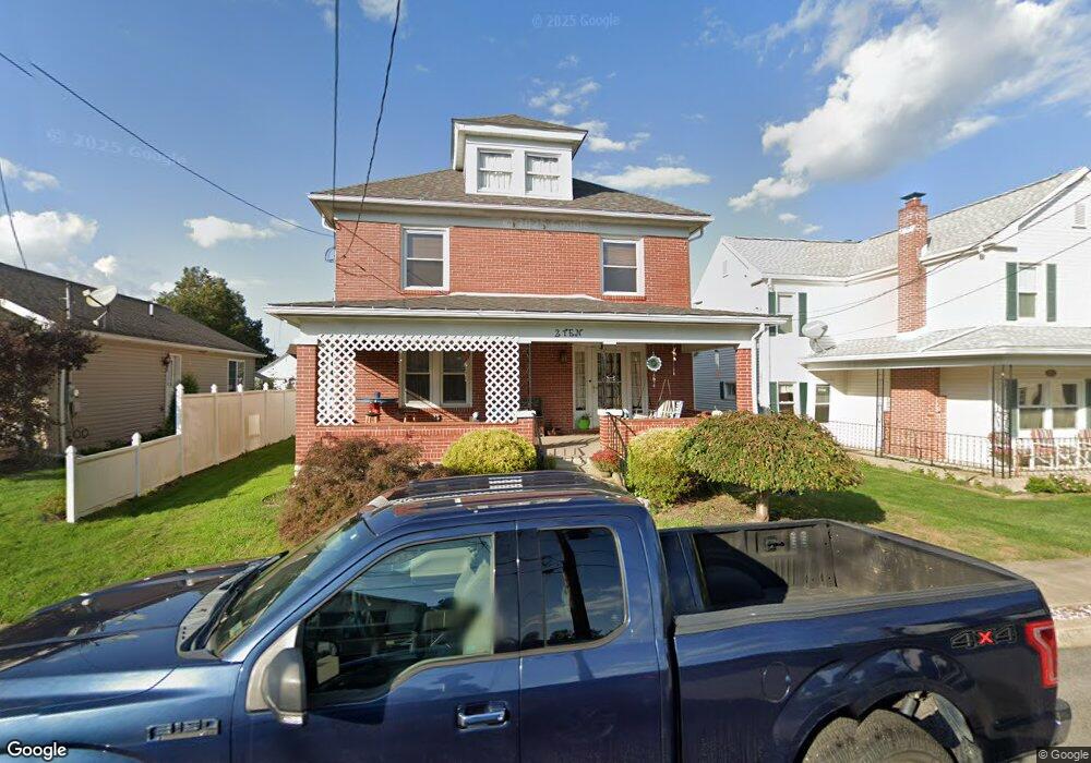
210 W Chestnut St Selinsgrove, PA 17870
Estimated Value: $90,999 - $264,000
--
Bed
--
Bath
--
Sq Ft
7,841
Sq Ft Lot
About This Home
This home is located at 210 W Chestnut St, Selinsgrove, PA 17870 and is currently estimated at $202,500. 210 W Chestnut St is a home located in Snyder County with nearby schools including Selinsgrove Area Elementary School, Selinsgrove Intermediate School, and Selinsgrove Area Middle School.
Ownership History
Date
Name
Owned For
Owner Type
Purchase Details
Closed on
Apr 29, 2016
Sold by
Mease Mildred Ruth
Bought by
Mease John Frederick
Current Estimated Value
Purchase Details
Closed on
Apr 10, 2014
Sold by
Milderd Milderd R
Bought by
Mease Mildred R
Purchase Details
Closed on
Apr 15, 2013
Sold by
Mease Kenneth Frederick
Bought by
Mease Kenneth Frederick and Mease Mildred Ruth
Purchase Details
Closed on
Dec 28, 2012
Sold by
Selmax Corp
Bought by
Mease Kennth Frederick
Purchase Details
Closed on
Aug 13, 2009
Sold by
Mease Kenneth W and Mease Helen M
Bought by
Mease Kenneth W
Create a Home Valuation Report for This Property
The Home Valuation Report is an in-depth analysis detailing your home's value as well as a comparison with similar homes in the area
Home Values in the Area
Average Home Value in this Area
Purchase History
| Date | Buyer | Sale Price | Title Company |
|---|---|---|---|
| Mease John Frederick | -- | Attorney | |
| Mease Mildred R | -- | -- | |
| Mease Kenneth Frederick | -- | -- | |
| Mease Kennth Frederick | -- | -- | |
| Mease Kenneth W | -- | -- |
Source: Public Records
Mortgage History
| Date | Status | Borrower | Loan Amount |
|---|---|---|---|
| Closed | Mease Kenneth W | -- | |
| Closed | Mease Kenneth Frederick | $0 |
Source: Public Records
Tax History Compared to Growth
Tax History
| Year | Tax Paid | Tax Assessment Tax Assessment Total Assessment is a certain percentage of the fair market value that is determined by local assessors to be the total taxable value of land and additions on the property. | Land | Improvement |
|---|---|---|---|---|
| 2025 | $1,916 | $16,020 | $1,800 | $14,220 |
| 2024 | $1,799 | $16,020 | $1,800 | $14,220 |
| 2023 | $718 | $16,020 | $1,800 | $14,220 |
| 2022 | $1,727 | $16,020 | $1,800 | $14,220 |
| 2021 | $1,711 | $16,020 | $1,800 | $14,220 |
| 2020 | $1,703 | $16,020 | $1,800 | $14,220 |
| 2019 | $1,695 | $16,020 | $1,800 | $14,220 |
| 2018 | $1,679 | $16,020 | $1,800 | $14,220 |
| 2017 | $1,663 | $16,020 | $1,800 | $14,220 |
| 2016 | $894 | $16,020 | $1,800 | $14,220 |
| 2015 | $58,974 | $16,020 | $1,800 | $14,220 |
| 2014 | $58,974 | $16,020 | $1,800 | $14,220 |
Source: Public Records
Map
Nearby Homes
- 211 W Pine St
- 207 Orange St Unit 209
- 500 N Orange St
- 511 N 10th St
- 00 S Market St
- 722 N 8th St
- 223 E Pine St
- Lot 1 522 Route S
- 321 Pleasant Dr
- 20 Quarry Rd
- 12 Minton Dr
- 0 Wedgewood Dr
- 456 State School Rd
- 9130 State Route 147
- 1262 N Old Trail
- 85 Old Colony Rd
- 732 Salem Rd
- 0 Mill Rd
- 594 Augusta Dr
- 0 Roosevelt Ave
- 208 W Chestnut St
- 214 W Chestnut St
- 216 W Chestnut St Unit 218
- 220 W Chestnut St
- 202 W Chestnut St
- 111 Independence St
- 107 Independence St
- 113 Independence St
- 105 Independence St
- 215 W Chestnut St
- 117 Independence St
- 217 W Chestnut St
- 110 Orange St
- 219 W Chestnut St
- 222 W Chestnut St
- 203 W Chestnut St
- 119 Independence St Unit 121
- 114 Orange St
- 123 Independence St
- 125 Independence St