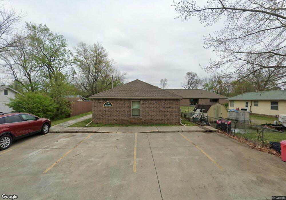
210 Walnut St Prairie Grove, AR 72753
Estimated Value: $227,000 - $830,000
--
Bed
2
Baths
1,602
Sq Ft
$252/Sq Ft
Est. Value
About This Home
This home is located at 210 Walnut St, Prairie Grove, AR 72753 and is currently estimated at $403,807, approximately $252 per square foot. 210 Walnut St is a home with nearby schools including Prairie Grove Elementary School, Prairie Grove Middle School, and Prairie Grove Junior High School.
Ownership History
Date
Name
Owned For
Owner Type
Purchase Details
Closed on
Aug 29, 2014
Sold by
Kessler Dianne M and Kessler Bruce A
Bought by
Fidler Michael Howard
Current Estimated Value
Purchase Details
Closed on
Jan 20, 1995
Bought by
Favichia Dianne M
Purchase Details
Closed on
Feb 17, 1992
Bought by
Ellis Era E
Purchase Details
Closed on
Feb 1, 1992
Bought by
Ellis George A and Ellis Era E
Purchase Details
Closed on
Jun 7, 1985
Bought by
Skelton Richard D and Skelton Lora B
Create a Home Valuation Report for This Property
The Home Valuation Report is an in-depth analysis detailing your home's value as well as a comparison with similar homes in the area
Home Values in the Area
Average Home Value in this Area
Purchase History
| Date | Buyer | Sale Price | Title Company |
|---|---|---|---|
| Fidler Michael Howard | $20,000 | None Available | |
| Favichia Dianne M | -- | -- | |
| Ellis Era E | -- | -- | |
| Ellis George A | $20,000 | -- | |
| Skelton Richard D | -- | -- |
Source: Public Records
Tax History Compared to Growth
Tax History
| Year | Tax Paid | Tax Assessment Tax Assessment Total Assessment is a certain percentage of the fair market value that is determined by local assessors to be the total taxable value of land and additions on the property. | Land | Improvement |
|---|---|---|---|---|
| 2025 | $1,624 | $43,050 | $9,100 | $33,950 |
| 2024 | $1,523 | $43,050 | $9,100 | $33,950 |
| 2023 | $1,449 | $43,050 | $9,100 | $33,950 |
| 2022 | $1,318 | $24,400 | $2,800 | $21,600 |
| 2021 | $1,264 | $24,400 | $2,800 | $21,600 |
| 2020 | $1,155 | $24,400 | $2,800 | $21,600 |
| 2019 | $1,061 | $19,510 | $3,000 | $16,510 |
| 2018 | $163 | $3,000 | $3,000 | $0 |
| 2017 | $16 | $3,000 | $3,000 | $0 |
| 2016 | $351 | $6,520 | $4,600 | $1,920 |
| 2015 | $351 | $6,520 | $4,600 | $1,920 |
| 2014 | $356 | $6,600 | $4,600 | $2,000 |
Source: Public Records
Map
Nearby Homes
- 4.66 +/- AC Tract 5 Hwy 62 & S Mock St
- TBD Kate Smith St
- 601 Westwood Ave
- Lot 2 Holmes St
- 208 N Neal St
- 211 Boston St
- 106 S Ozark St
- 110 Cypress St
- 107 S Ozark St
- 703 Grant Ave
- 304 S Summit St
- 308 S Summit St
- 311 S Mock St
- 204 Armstrong St
- 606 1/2 E Buchanan St
- 901 E Buchanan St
- 881 E Buchanan St
- 661 Summer Ln
- 600 Kendra St
- 621 Kendra St
- 203 W Cleveland St
- 206 Walnut St
- 201 W Cleveland St
- 207 W Cleveland St
- 208 Elm St
- 207 Walnut St
- 216 W Cleveland St
- 200 W Thurman St
- 217 W Cleveland St
- 208 W Thurman St
- 111 W Cleveland St
- 205 Elm St
- 210 W Thurman St
- 112 W Cleveland St
- 206 Hickory St
- 209 Elm St
- 109 W Cleveland St
- 214 W Thurman St
- 112 W Thurman St
- 303 W Cleveland St