Estimated Value: $163,000 - $230,220
3
Beds
2
Baths
1,664
Sq Ft
$115/Sq Ft
Est. Value
About This Home
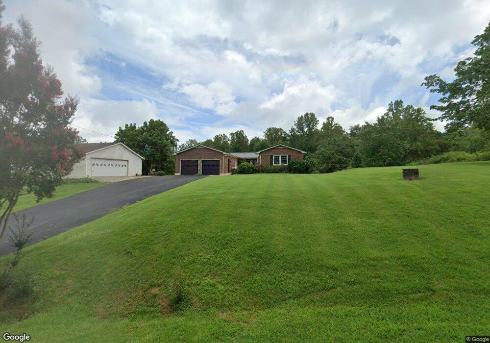
This home is located at 210 Wilhaven Ln, Axton, VA 24054 and is currently estimated at $191,805, approximately $115 per square foot. 210 Wilhaven Ln is a home located in Henry County with nearby schools including Axton Elementary School, Laurel Park Middle School, and Magna Vista High School.
Ownership History
Date
Name
Owned For
Owner Type
Purchase Details
Closed on
Sep 23, 2011
Sold by
Hertzler Joe and Hertzler Norma J
Bought by
Hertzler Jesse C
Current Estimated Value
Home Financials for this Owner
Home Financials are based on the most recent Mortgage that was taken out on this home.
Original Mortgage
$110,000
Outstanding Balance
$75,579
Interest Rate
4.33%
Mortgage Type
New Conventional
Estimated Equity
$116,226
Purchase Details
Closed on
Mar 17, 2010
Sold by
Hsbc Bank Usa Na
Bought by
Hertzler Joe
Create a Home Valuation Report for This Property
The Home Valuation Report is an in-depth analysis detailing your home's value as well as a comparison with similar homes in the area
Purchase History
| Date | Buyer | Sale Price | Title Company |
|---|---|---|---|
| Hertzler Jesse C | $110,000 | -- | |
| Hertzler Joe | $51,000 | -- |
Source: Public Records
Mortgage History
| Date | Status | Borrower | Loan Amount |
|---|---|---|---|
| Open | Hertzler Joe | $110,000 |
Source: Public Records
Tax History
| Year | Tax Paid | Tax Assessment Tax Assessment Total Assessment is a certain percentage of the fair market value that is determined by local assessors to be the total taxable value of land and additions on the property. | Land | Improvement |
|---|---|---|---|---|
| 2025 | $663 | $119,500 | $15,800 | $103,700 |
| 2024 | $66,323 | $119,500 | $15,800 | $103,700 |
| 2023 | $663 | $119,500 | $15,800 | $103,700 |
| 2022 | $663 | $119,500 | $15,800 | $103,700 |
| 2021 | $663 | $119,500 | $15,800 | $103,700 |
| 2020 | $674 | $121,400 | $15,800 | $105,600 |
| 2019 | $674 | $121,400 | $15,800 | $105,600 |
| 2018 | $67,377 | $121,400 | $15,800 | $105,600 |
| 2017 | $67,377 | $121,400 | $15,800 | $105,600 |
| 2016 | $60,414 | $123,800 | $15,800 | $108,000 |
| 2015 | $60,414 | $123,800 | $15,800 | $108,000 |
| 2014 | $60,414 | $123,800 | $15,800 | $108,000 |
Source: Public Records
Map
Nearby Homes
- 00 Mount Vernon Rd
- 2562 Sandy River Rd
- 4161 Wyatt Farm Rd
- 8667 Chatham Rd
- 1733 Mosco Rd
- 190 Holland Cir
- 0 Wyatt Farm Rd
- 179 Winnie Ln
- 888 Mountain Valley Rd
- 4922 Chatham Rd
- 340 Martin Dr
- 4299 N Fork Rd
- 60 Elijah Cir
- 2640 Brookside Rd
- 375 River Ridge Ln
- 1028 Wyatt Farm Rd
- 3732 Water Oak Rd
- 2993 Medical Center Rd
- 2001 Mapleton Dr
- 00 Laurel Park Ave
- 221 Wilhaven Ln
- 185 Wilhaven Ln
- 143 Mountain Valley Rd
- 316 Wilhaven Ln
- 313 Wilhaven Ln
- 94 Wilhaven Ln
- 5532 Mountain Valley Rd
- 22 Wilhaven Ln
- 27 Wilhaven Ln
- 5510 Mountain Valley Rd
- 9027 Mountain Valley Rd
- 5331 Mountain Valley Rd
- 5331 Mountain Valley Rd
- 432 Wilhaven Ln
- 5427 Mountain Valley Rd
- 437 Wilhaven Ln
- 5346 Mountain Valley Rd
- 5340 Mountain Valley Rd
- 5675 Mountain Valley Rd
- 269 Collins Rd
Your Personal Tour Guide
Ask me questions while you tour the home.