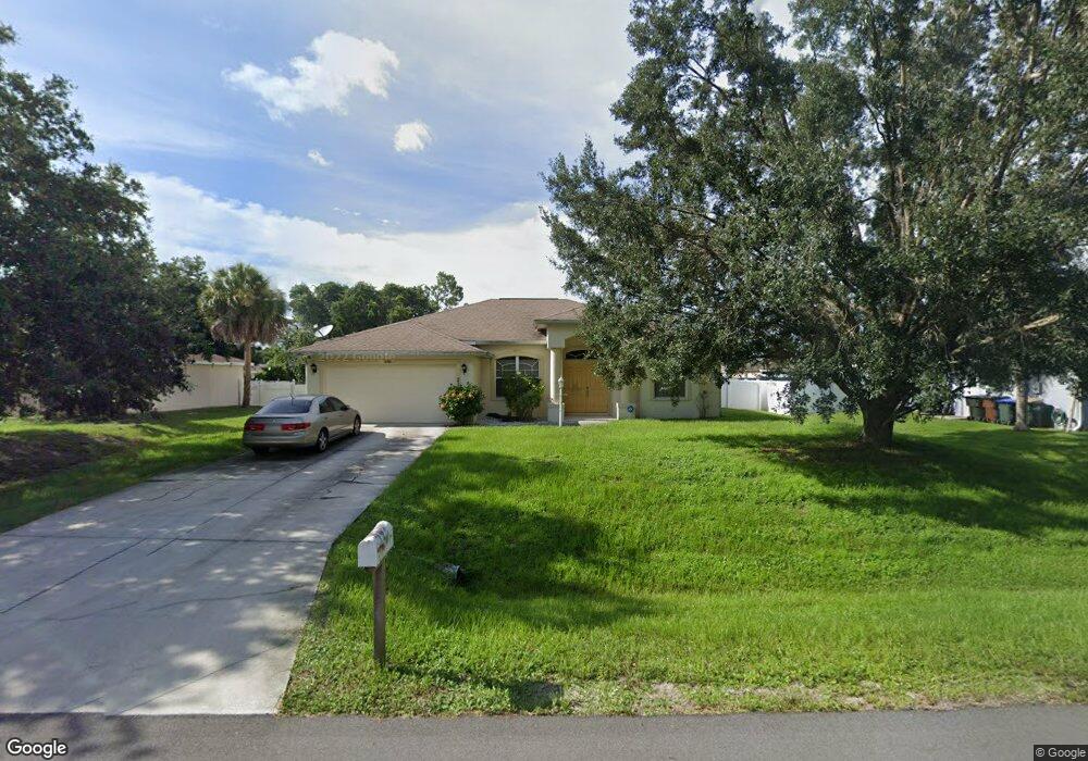
2100 Alliance Ave North Port, FL 34286
Estimated Value: $300,266 - $341,000
3
Beds
2
Baths
1,807
Sq Ft
$178/Sq Ft
Est. Value
About This Home
This home is located at 2100 Alliance Ave, North Port, FL 34286 and is currently estimated at $322,317, approximately $178 per square foot. 2100 Alliance Ave is a home located in Sarasota County with nearby schools including Toledo Blade Elementary School, North Port High School, and Woodland Middle School.
Ownership History
Date
Name
Owned For
Owner Type
Purchase Details
Closed on
Aug 27, 2008
Sold by
Brod Allen
Bought by
Butler Quinton D and Butler Donna A
Current Estimated Value
Home Financials for this Owner
Home Financials are based on the most recent Mortgage that was taken out on this home.
Original Mortgage
$148,100
Outstanding Balance
$96,220
Interest Rate
6.21%
Mortgage Type
VA
Estimated Equity
$226,097
Purchase Details
Closed on
Sep 7, 2005
Sold by
Rogers William and Rocca John
Bought by
Brod Allen
Home Financials for this Owner
Home Financials are based on the most recent Mortgage that was taken out on this home.
Original Mortgage
$246,900
Interest Rate
5.75%
Mortgage Type
Construction
Purchase Details
Closed on
Jun 25, 1999
Sold by
Clerk Circuit Court
Bought by
M B M Innovations L L C
Create a Home Valuation Report for This Property
The Home Valuation Report is an in-depth analysis detailing your home's value as well as a comparison with similar homes in the area
Home Values in the Area
Average Home Value in this Area
Purchase History
| Date | Buyer | Sale Price | Title Company |
|---|---|---|---|
| Butler Quinton D | $145,000 | Attorney | |
| Brod Allen | $50,000 | -- | |
| M B M Innovations L L C | $1,000 | -- |
Source: Public Records
Mortgage History
| Date | Status | Borrower | Loan Amount |
|---|---|---|---|
| Open | Butler Quinton D | $148,100 | |
| Previous Owner | Brod Allen | $246,900 |
Source: Public Records
Tax History Compared to Growth
Tax History
| Year | Tax Paid | Tax Assessment Tax Assessment Total Assessment is a certain percentage of the fair market value that is determined by local assessors to be the total taxable value of land and additions on the property. | Land | Improvement |
|---|---|---|---|---|
| 2024 | $2,785 | $111,453 | -- | -- |
| 2023 | $2,785 | $98,507 | $0 | $0 |
| 2022 | $2,872 | $105,338 | $0 | $0 |
| 2021 | $2,781 | $102,270 | $0 | $0 |
| 2020 | $2,750 | $100,858 | $0 | $0 |
| 2019 | $1,651 | $98,590 | $0 | $0 |
| 2018 | $1,519 | $96,752 | $0 | $0 |
| 2017 | $1,487 | $94,762 | $0 | $0 |
| 2016 | $1,478 | $151,000 | $4,800 | $146,200 |
| 2015 | $1,486 | $125,800 | $4,300 | $121,500 |
| 2014 | $1,463 | $90,086 | $0 | $0 |
Source: Public Records
Map
Nearby Homes
- 0 Ann Arbor Rd Unit A4520722
- 2111 Baltimore St
- 0 Snover Ave
- Lot 32 Baltimore St
- 1956 Snover Ave
- LOT 45 Burlington St
- LOT 44 Burlington St
- 2468 Burlington St
- 2267 Cincinnati St
- 0 Yacolt Ave Unit MFRA4665223
- 2031 Baltimore St
- 0 Circleville St Unit MFRC7506886
- 0 Circleville St Unit MFRC7492644
- 0 Circleville St Unit MFRC7492646
- 2343 Cincinnati St
- Lot 5 Alhaven Terrace
- 2551 Alhaven Terrace
- 0 Trilby Ave Unit R11102643
- 0 Wyola Ave Unit MFRC7507151
- 0 Alhaven Terrace Unit MFRN6130985
- 2114 Alliance Ave
- 2086 Alliance Ave
- 2163 Altitude Ave
- 2128 Alliance Ave
- 2128 Avenue
- 2149 Altitude Ave
- 2191 Altitude Ave
- 2072 Alliance Ave
- 2075 Alliance Ave
- 2142 Alliance Ave
- 2125 Alliance Ave
- 2205 Altitude Ave
- 2058 Alliance Ave
- 2184 Altitude Ave
- 2156 Altitude Ave
- 0 Altitude Ave Unit R4706492
- 2107 Altitude Ave
- 2192 Altitude Ave
- 2136 Altitude Ave
- 2044 Alliance Ave